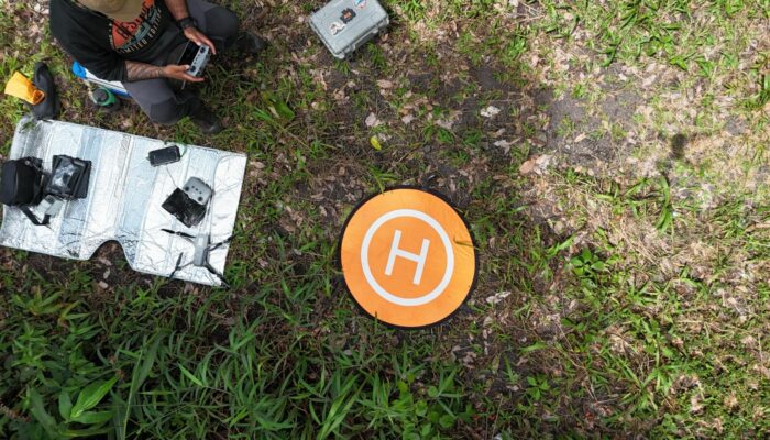
Geological teaching and education is fast-changing in the 21st century. While fieldwork has long been considered to be the bedrock of geological instruction, over time an increased acceptance has developed for the need to make geological education and training more accessible, especially with regard to fieldwork as this can often involve days and weeks of arduous treks over inhospitable terrain, that may be deemed exclusionary for students with disabilities. With the advent of sophisticated drones bearing advanced camera systems and in some instances even Light Detection and Ranging (LiDAR) capabilities, geological mapping has in many instances become easier and more inclusive, with people with disabilities able to participate in geological mapping exercises.
In this blog post, I have conversed with Dr. Duccio Gheri, a postdoctoral research associate at the University of Liverpool, who is a geophysicist whose work focuses on understanding lahar dynamics using seismic and acoustic measurements. His research looks at how these flows propagate, how much material they transport, and how they reshape river channels and how this information can be used to improve monitoring and early-warning systems.
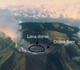
Dr. Gheri used a drone during fieldwork in Guatemala on one flank of the Fuego volcano to complement geophysical observations. From a geophysical perspective, one of the key open questions is how to quantify sediment transport, erosion, and deposition during a lahar. Drone-based mapping allowed him to reconstruct the channel topography before and after an event, estimate where material has been eroded or deposited, and provide realistic inputs for numerical models of lahar runout and hazard.
1) Can you briefly describe how drones work in terms of mapping an area?
When mapping an area with a drone, the most effective approach is to plan the survey in advance using a predefined flight plan. A flight plan allows you to design a systematic path that ensures the entire area of interest is covered, with images collected at a consistent altitude and spacing. During the flight, the drone automatically acquires photographs at regular a time interval that is set before take-off.
It is also possible to map an area without a predefined flight plan by flying the drone manually, but this requires much more care and experience. In both cases, the key requirement is that each photograph overlaps with the previous and subsequent images, typically by about 70–80%. This overlap is essential for photogrammetric processing, as it allows software to identify common features across images and reconstruct a three-dimensional point cloud, orthomosaic, and digital elevation model.
Images are ideally acquired with the camera pointing vertically downward, but small camera inclinations are often acceptable and can even be beneficial. Oblique images help capture vertical or steep features such as channel banks, cliffs, or large boulders, which are common in natural environments and improve the overall quality of the reconstruction.
2) What sort of things do you look out for before you begin mapping an area?
Before flying, I mainly assess visibility and accessibility. For the type of lightweight drone that I use, flights must be conducted within visual line of sight, which can be challenging sometimes in natural environments with dense vegetation, steep topography, or narrow valleys. I also look for open, safe areas for take-off and landing, and, of course, the weather. A sunny, calm day is ideal; strong wind is great for kites, but not so much for drones!
A crucial step is the use of ground control points (GCPs). These are fixed points on the ground with known coordinates that are photographed by the drone during the flight and later used to accurately reference and georeference the survey. GCPs are particularly important for improving the vertical accuracy of digital elevation models and for comparing surveys acquired at different times.
From a scientific perspective, it is equally important to define the purpose of the survey in advance. Whether the goal is to reconstruct topography, quantify erosion and deposition, or analyse surface textures directly influences flight altitude, camera settings, and the area where the survey begins. In my experience, careful planning before take-off makes a huge difference to the quality of the final product.
Ah, I was forgetting another import thing: making sure all the batteries are charged and the micro-SD card is in the drone!
3) What sort of challenges have you faced while using a drone for mapping in the field?
One challenge is maintaining good visibility and a stable signal in complex natural environments. Forested areas, steep channel walls, or sharp bends in canyons (if you fly through them) can interrupt the radio link or degrade GPS reception, which limits how and where the drone can be flown.
Wind is another major issue. It affects not only flight stability but also battery consumption. Flying downwind is easy, but returning upwind requires much more energy, so careful planning is essential to ensure the drone can safely return to its take-off point, otherwise, there is a real risk of losing it somewhere in the field.
Lighting conditions also play an important role. Shadows, passing clouds, or strong contrasts in illumination can reduce image quality and make the later processing steps, such as generating orthomosaics or digital elevation models, more challenging.
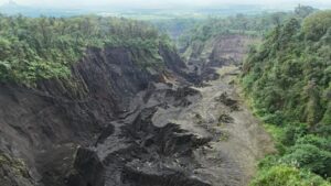
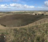
A canyon formed by erosion of volcanic lahar in Guatemala, imaged using a drone. Image courtesy Dr. Duccio Gheri.
4) What steps do you follow after the drone-based imaging is complete?
After data acquisition, the first step is to filter the images by removing blurred frames, poorly illuminated photos, or pictures affected by clouds or strong shadows.
The remaining images are then processed using photogrammetry software, both commercial (es., Agisoft Metashape) and open-source (es. OpenDroneMap) options are available. Even for someone relatively new to drones, the workflow is quite intuitive and allows reliable reconstruction of digital elevation models (DEMs) and orthomosaics.
A key step at this stage is identifying the ground control points (GCPs) in the images before running the full processing. This allows the software to correct the camera positions and, in particular, to reduce vertical inaccuracies associated with the drone’s onboard GPS. Without GCPs, the final products are still useful, but elevations remain relative rather than absolute.
Once this step is completed, the software automatically aligns the images and reconstructs a three-dimensional point cloud, which is essentially a dense collection of points in space representing the shape of the terrain and surface features. From this point cloud, it is then possible to generate a digital elevation model (DEM) and an orthomosaic.
In our case, the drone data were analysed with a high-resolution orthomosaic produced by Agisoft Metashape, which allowed us to accurately measure channel geometry and to reference fixed features visible in the camera footage.
5) If readers were interested in using drones for mapping projects, could you recommend some drone models and literature?
My experience shows that lightweight DJI drones are a very good entry point: they are relatively affordable, easy to operate, and equipped with high-quality cameras suitable for scientific mapping.
More important than the specific model is understanding the principles of photogrammetry and survey design such as image overlap, flight planning, and the use of ground control points.
Drone-based mapping is now supported by a wide range of scientific studies, practical guides, and many clear tutorials available on YouTube. Even with limited prior experience, following some basic instruction, it is possible to produce reliable topographic datasets suitable for quantitative analysis.
Dr. Gheri can be reached at D.Gheri@liverpool.ac.uk
meme builder
This was truly inspiring. It’s amazing how drones are not replacing fieldwork, but making it more inclusive and accessible. That shift feels meaningful. Using drone mapping at Volcán de Fuego to measure erosion and improve hazard models shows how powerful this technology can be — not just for research, but for safety and real-world impact. Geology is evolving, and it’s exciting to see innovation expanding who gets to explore and understand our planet.