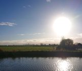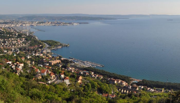
The city of Trieste lies in north-eastern Italy along the border with Slovenia. It is positioned at the corner point between the Romance, Germanic and Slavic worlds and serves as an important seaport in the region. It is fascinating for both its history and geology. My relationship with Italy’s town of Science, as Trieste is often referred to, started about a year ago. I got the opportunity to start a PhD focused on imaging evaporates, at the University of Trieste and the Istituto Nazionale di Oceanografia e di Geofisica Sperimentale (OGS). Walking around the city, two elements caught my attention. First, I was impressed by the topography of the area (Figure 1), the city itself is bordered by beautiful abrupt cliffs and steep Carsic hills plunging into the Adriatic Sea. Second, I found myself surprised I was in Italy, as the Austro-Viennese architecture dominates the streets. While I was marvelling at the beauty and size of the buildings, which nowadays testify of a thriving and multicultural past, I have started to wonder why I had never heard about this city before. The history of Trieste is out of topic of this article, but I invite you to check it out, as there are many lessons that can be learned regarding Identity politics. So, why should Trieste appear in the ‘Geology in the city’ series? First let’s zoom out and review the regional geological context.
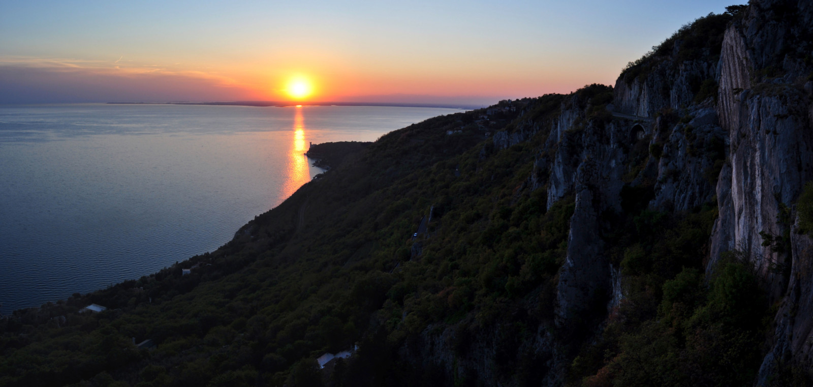
Figure 1. The carbonate cliffs of the Strada Napoleonica at sunset, an idyllic spot for climbing and wandering. The subvertical strata represent the southwestern flank of the Trieste – Komen anticlinorium developed above the NW-SE Karst Thrust. The strata visible here are the latest limestone units, Paleocene to Eocene in age. The lower part of the slope covered by vegetation is made of Eocene Flysch. Credit: Simon Blondel.
A natural fortress
Trieste is built along the north-eastern Adriatic coast, where it lies on top of Eocene flysch, which consist of silty marls interbedded with sandstones. They don’t outcrop much, but you can see evidence of these all around the city. The sandstone interbeds were used as building blocks, regionally called “masegni”, to build the city. For example, the Molo Audace (an iconic pier at the harbour) and the pavement of the city’s main square: the breath-taking Piazza dell’Unità d’Italia, are made of these “masegni” (Figure 2).
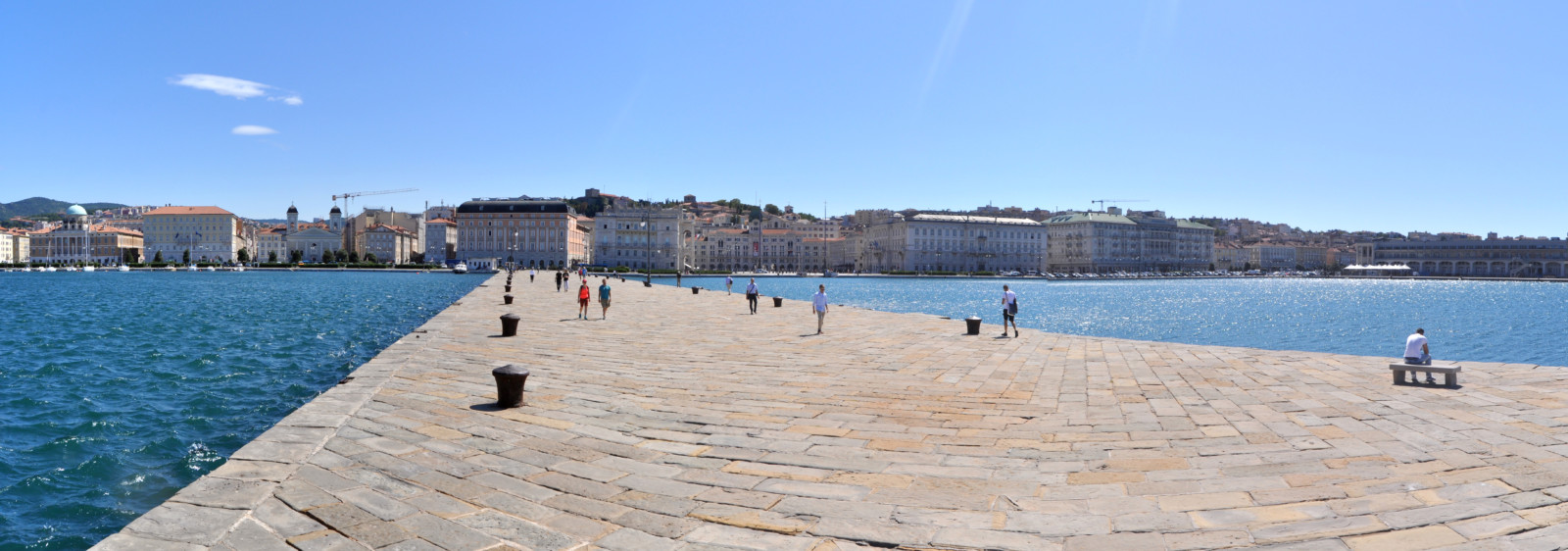
Figure 2. View of Città nuova from Molo Audace, with Piazza dell’Unità d’Italia at the centre. The pier is built above the wreck of ship that sank in the port of Trieste in 1740. It is made of “masegni” stones extracted from the sandstone units of the Eocene Flysch. Credit: Simon Blondel.
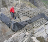
As you go inland, the topography abruptly steepens toward the Karst plateau. It rises 400 m above the Gulf of Trieste, overhanging the city and confining it with cliffs and walls, to the delight of many climbers. When I say Karst I mean the geographical name given to this area and not the geological term, but I’ll come back to that a bit later. After this exhausting ascent, especially if you decide to do it by bike (my first excursion with a single-geared Dutch bike was quite gruelling), you can relax and wander around the flat “Altopiano Triestino”. It consists of limestone and dolomitic limestone formations, Valanginian to early Eocene in age. They are assimilated to a succession of carbonate platforms, whose nomenclature was recently unified within the framework of the HYDROKARST European project in 2015 (http://book.hydrokarst-project.eu/files/assets/basic-html/index.html#1). They were brought to the surface with the collision between the Eurasian and African plates, and nowadays form a wide NW-SE fold – the Trieste – Komen anticlinorium- assimilated to the external Dinaric Imbricated Belt (Figure 3).
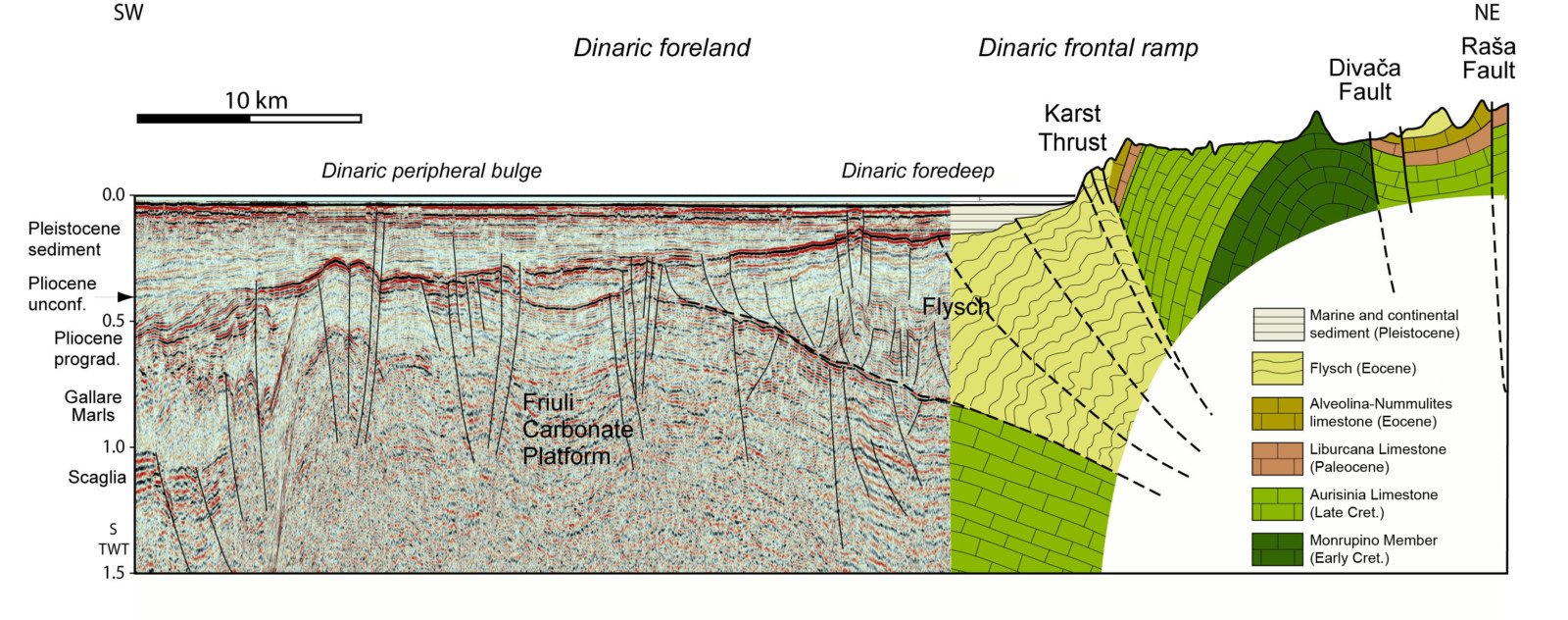
Figure 3. Simplified geological map of the Gulf of Trieste. The A-B line represents the position of the cross-section in Figure 4. The green part corresponds to the seismic data, the purple part corresponds to the schematic cross-section. Trieste lies above Eocene flysch, at the front of the NW-SE Karst Thrust that delimit the Karst plateau. Offshore, the Karst’s carbonate platform is repeatedly thrusted and folded until the margin of the platform. Courtesy of Martina Busetti.
The anticlinorium overthrusts the Eocene flysch that deposited at its foreland (the Gulf of Trieste), along the NW – SE Karst and Palmanova thrusts (Figure 4). The Karst’s carbonates were also widely used in construction and there are many quarries in the surroundings. One of the most famous is near Villaggio del Pescatore, where a perfectly preserved skeleton of Tethyshadros insularis (Antonio to his friends) was discovered in 1994 (Figure 5).
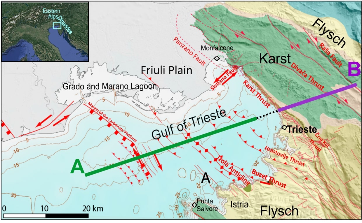
Figure 4. Seismic (data acquired in the gulf) and geological schematic cross-section (of the Karst Plateau) perpendicular to the Karst Thrust, as shown on Figure 3. The Carbonate platform is folded and thrusted along the Karst thrust, overlapping the younger Eocene Flysch along the coast. Offshore the Flysch are covered by Pliocene and Pleistocene sediments, and onlap the folded Carbonate platform. Courtesy of Martina Busetti.
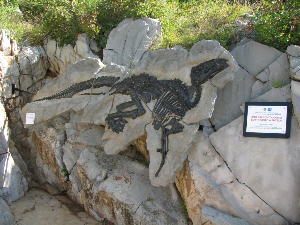
Figure 5. The reconstructed skeleton of Antonio in a former limestone quarry located between Duino and Villaggio del Pescatore). The original fossil was moved to the Museum of Natural History in Trieste. Credit: www.dinosauroantonio.it
From Kras to Karst
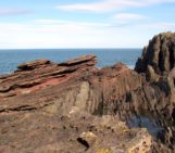
As stated previously, the word Karst is both a geographical and geological term in the region. At the beginning, this was just the name given to the hinterland of the Gulf of Trieste. It is supposed to be of pre-Indoeuropean origin from the root kar-, meaning rock, to describe these unusual and barren lands that were considered hostile for travellers. This term is still preserved in the Italian Carso, Slovenian Kras and German Karst. On the surface, the Karst plateau is strewed by numerous dolines and caves, which are the most dominant features that characterize it. There are many other geomorphological features that can be observed, such as the campi solcati (limestone pavement) or the kamenitze (natural ponds) in Val Rosandra (Figure 6). These natural ponds result from millions of years of erosion and dissolution by meteoritic waters of pre-existing carbonates.
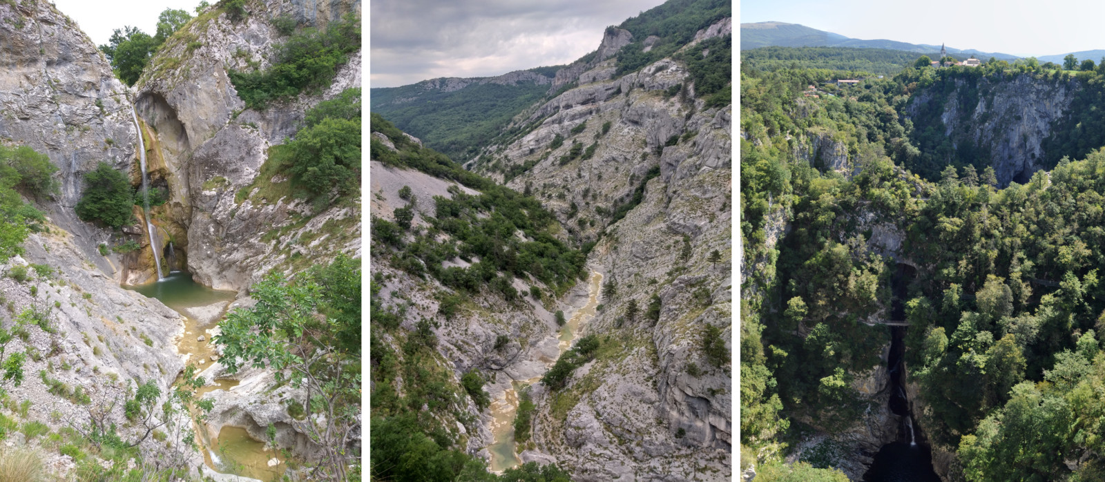
Figure 6. From left to right, waterfall emerging from the Karst in Val Rosandra, The Val Rosandra valley with numerous Kamenitze and typical Carsic vegetation, the Škocjan caves where the Reka river plunges beneath the surface for a 40 km journey underground. Credit: Simon Blondel.
The use of the word Karst, as a general term to describe areas exhibiting various geomorphological features linked to erosion and dissolution, became widely accepted by the scientific community during the 19th century. Back then, Trieste was one of the most dynamic and multicultural city of the world under the Austro-Hungarian empire. Most of the population was Slovenian-speaking in the hinterland, therefore the region was referred as Kras by the locals. However, the geoscientists who started to investigate the origin of its features in more details were German-speaking, hence explaining why the German version has been retained for the geological term. What triggered these studies was principally the need for water. As the population grew, so did the need for freshwater, which led the city to launch investigations of the nearby Karst. Unfortunately for them, the water was too deep (at about 300 m below the surface, close to the sea level) to be easily pumped for the city. But in their quest for groundwater, the scientists discovered a dense and sinuous network of cavities and tunnels dug by the groundwater, close to the current sea-level. They discovered that a clear majority of the Karst’s underground water is captured by the Reka river that plunges underground through the ponor (natural sinkhole where surface water enters) of Škocjan, a UNESCO Natural Heritage site in Slovenia (Figure 7). It reappears out from the underworld 40 km away from Škocjan, at the Timavo springs, where it nourishes the 2 km long river that outflows into the Gulf of Trieste.
The Karst Plateau hosts numerous caves and I will only mention one to conclude: the Grotta Gigante. It was discovered in 1840 and currently is both a tourist attraction and an important location for scientific studies. It hosts a seismological station, a horizontal pendulum and a clinometer to calculate the movements of the earth’s (Figure 7), as well as a measuring station for water percolation and concretion, a monitoring system for Radon gas, and finally a probe sensor measuring the temperature and the electric conductivity of groundwater. Some of these are operated by the Istituto Nazionale di Oceanografia e di Geofisica Sperimentale and the Department of Mathematics and Geosciences of the University of Trieste.
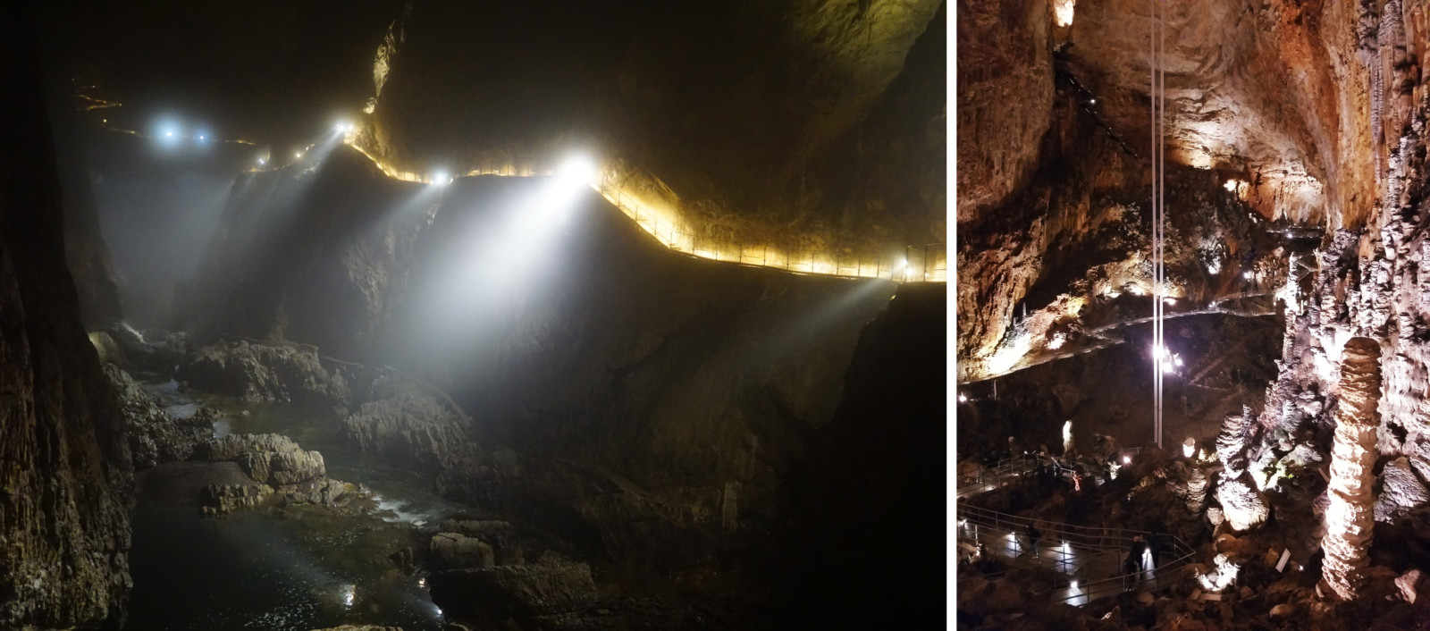
Figure 7. The Reka river flowing underground in the Škocjan caves (left) and the Grotta Gigante where we can notably see the two giant tubes protecting the horizontal pendulum used to calculate the movements of the Earth’s crust. Credit: Simon Blondel.
After reading this introduction to Trieste and its geology, it is time to come to visit us. The city is currently preparing to host the EuroScience Open Forum – ESOF 2020, so you’ll hear the name again. In the meantime, stay tuned to our ETN SALTGIANT’s research, a project funded by the European Union’s Horizon 2020 research and innovation grant, and follow us on LinkedIn and Twitter.
I would like to thank Martina Busetti and Michela Dal Cin (OGS), who reviewed and contributed to the writing of this article.