These blogposts present interviews with outstanding scientists that bloomed and shape the theory that revolutionised Earth Sciences — Plate Tectonics. Get to know them, learn from their experience, discover the pieces of advice they share and find out where the newest challenges lie!
Meeting Eric Calais
Eric Calais is Professor of Geophysics and Head of the Geosciences department at the Ecole Normale Supérieure in Paris, France. He was a postdoctoral researcher at Scripps Institution of Oceanography, then became a professor of geophysics at Purdue University (USA) where he remained for 12 years. He is renowned for his work on the kinematics and dynamics of active tectonic processes in Asia, Africa, and the Caribbean. Further, Prof. Calais is highly interested in geo-communication. He has served multiple times as expert-consultant in seismic hazard and risk reduction and was a scientific advisor to the United Nations in Haiti from 2010 to 2012.
We tend to be academics and nothing else, that is not sufficient
Where lies currently your main research interest?
My main goal is to understand the present day deformation of the Earth crust, but not only at tectonic plate boundaries, also in plate interiors.
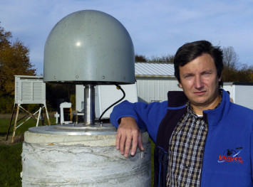
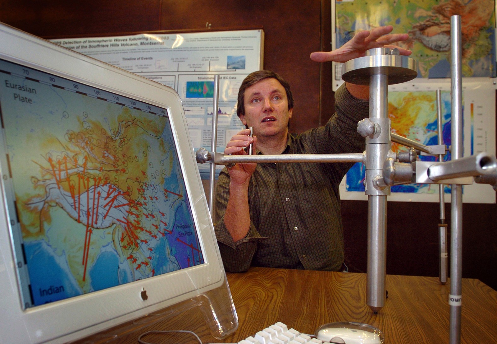
Eric Calais standing next to a GPS antenna at the Cherry Lane meteorological station of Purdue University. Credit: Purdue University
We have known for 50 years about Plate Tectonics. We know how to describe the motion of plates at the surface of our planet and we know that this has been going on for hundreds of millions of years. There are two questions I am interested in: What drives these motions? What is the engine? The second one is focused on the idea that the earthquake’s energy is released at plate boundaries, so they are linked to plate tectonics, but we really haven’t said much about why earthquakes occur. What is the mechanic of earthquake faulting? How is that driven by friction, stress, fluids? We are perhaps close to a significant transition in our understanding of earthquakes.
For part of my research, I look at the earthquake process from an angle that is different from that of most of my colleagues, who work in areas where there are a lot of earthquakes. I am interested in areas that are not deforming very rapidly or not at all, the internal parts of tectonic plates, but that do produce earthquakes from time to time. Sometimes very large ones. I try to understand why earthquakes occur within plate interiors and what does it mean in general. Of course, that could be then applied to any kind of earthquake.
What would you say is the favourite aspect of your research?
Fieldwork. That’s the reason why I went to Earth science instead of biology. Because I had the opportunity to be outside, not being confined to the lab. Another one is lectures with students and postdocs, with younger people. The older I grow, the more important the connection with them becomes. There is this notion that the younger generation is never as good as the previous one, I think this is wrong. They are as good, and probably much better than we were. I always learn from my students and PostDocs. Having the blessing of interacting with them, is something that is very important to me.
It’s really hard to make big changes in the real world as a scientist and influence some of the decisions […]
Why is your research relevant? What are the possible real world applications?
The real world applications of my research are twofold.
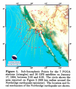
Calais & Minster (1995). GPS detection of ionospheric perturbations following the January 17, 1994, Northridge Earthquake. Geophysical Research Letters, 22(9), 1045–1048.
People like me who try to understand why earthquakes happen make measurements, calculations and models. Thanks to this we are able, not to make predictions, but to make assessments about how big the next earthquake may be. And this is already an important step towards earthquake safety. Because if you know what to expect you can integrate that information in seismic hazard models, then an engineer or an architect will be able to use this information to design earthquake-safe buildings. There is a strong link between the observations in the field, the measurements and the calculations we make, and the applications for earthquake safety.
The second aspect is communication with the broader public and with decision makers. It’s awareness raising amongst the population as a whole and also amongst the decision makers. That is the most difficult part of the job, really. The first part, converting measurements into something an engineer can use to better design a building, that’s the “easy” part, it’s doable and it is tractable, it is something that is very tangible for scientists and engineers.
The second one is much more difficult and it requires a lot of energy and you never know whether or not you succeed in making a point, in influencing decisions. Nevertheless, I think that scientists, as a whole, and in particular scientists working on earthquakes, have to step outside of their comfort zone. We tend to be academics and nothing else, that is not sufficient. We need to go out and speak about what we know and speak at the proper level to raise awareness amongst the population.
What do you consider to be your biggest academic achievement?
Post-2010 earthquake measurements in Haiti – Credit: Ecole Normale Supérieure, Eric Calais
It’s hard to tell… I think that we have been able to change the way one thinks about earthquakes within plate interiors over the past years. It’s hard to talk about achievement at this point but I would say there is a trend. If that trend continues, I have high hopes that it will lead us to a better understanding of why earthquakes occur, not only within plate interiors. Many people might not be interested, or they might not even be aware that there are significant earthquakes in plate interiors.
In France, we care a lot about that because 70% of the energy we use comes from nuclear power and we want those nuclear power plants to be earthquake safe. So what is the potential of an earthquake hitting one of those in France or Germany or anywhere in the world is a multibillion-dollar question. It is very interesting to study the earthquake process within plate interiors where you do not have to worry about plate motions or complications, the system is quite simple. I think it’s a system that is more tractable than the plate boundary system, which is more complicated. Trying to make progress in understanding this particular type of earthquakes is something I am pushing hard for right now in my research, with colleagues, PhD students and postdocs. I think that if we understand them better, we will have progressed towards understanding earthquakes as a whole.
Again, I’m not sure this is an achievement, but I am happy I worked with the Haitian Government under the United Nations as a scientific advisor after the earthquake in 2010 in Haiti. The earthquake was not that big, magnitude 7.1, but it had a large impact on the population and the economy. I am happy that I was able to step in and trigger some small changes. It’s really hard to make big changes in the real world as a scientist and influence some of the decisions that were made during the reconstruction that followed the earthquake. In a way, this was an achievement, but again very hard to measure quantitatively.
Do we ever solve problems or do we discover more problems?
What would you say is the main problem that you solved during your most recent project?
Do we ever solve problems or do we discover more problems? (laughs) I think the problems that I’ve solved are easy problems. I would take two recent examples:
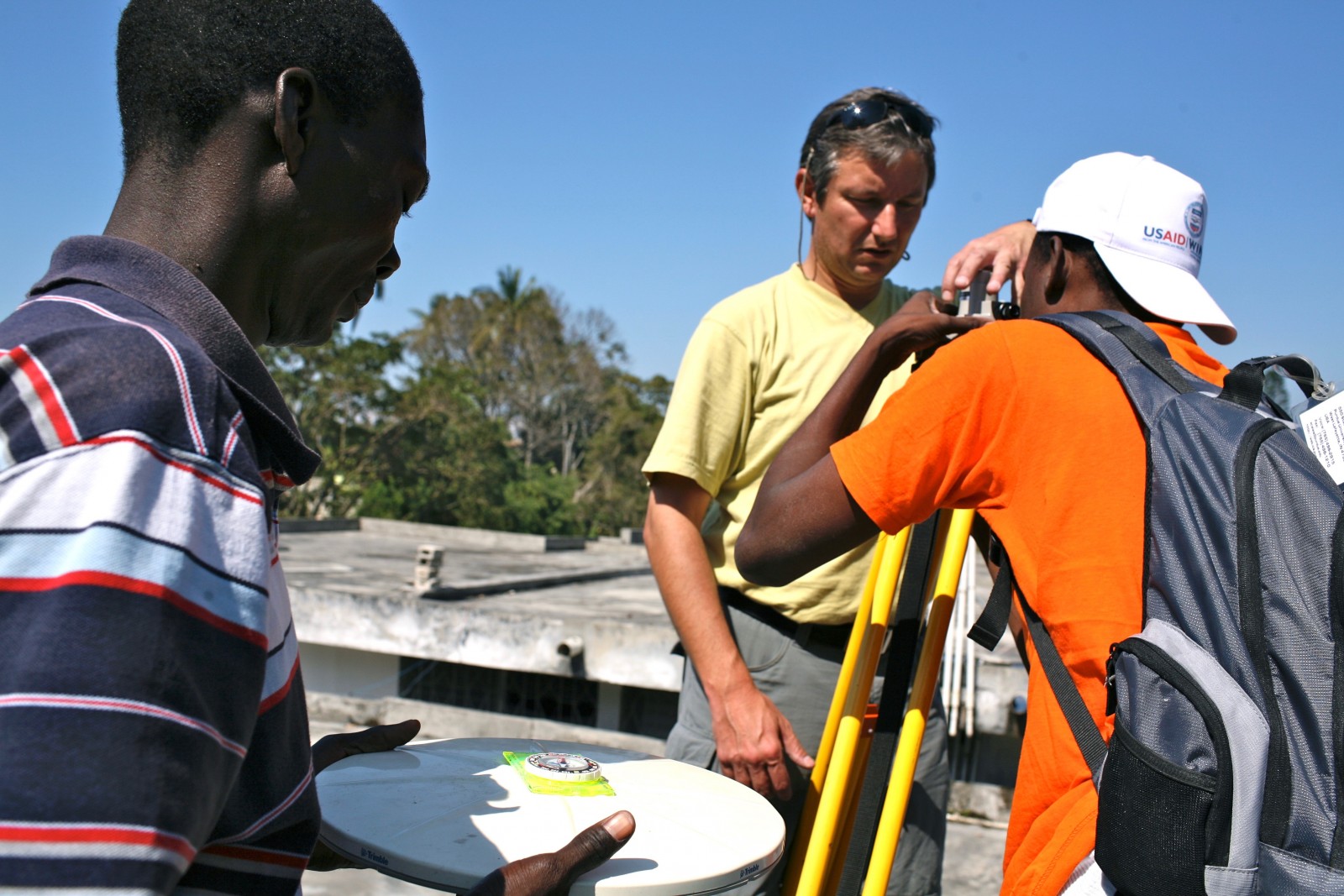
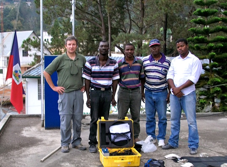
Installation of a GPS measurement site in Haiti after the 2010 earthquake. Credit: Eric Calais
One of the problems we were facing a few years ago, was whether there is or not an accumulation of deformation in some areas inside continents that will lead to earthquakes in the future. At plate boundaries we see that faults accumulate elastic energy that is measurable. And we know that this energy will be released during earthquakes to come. The system is simple in a way. But what about geologically stable continents? There was a big debate some years ago whether or not the same would occur inside continents.
We were able to show, and I think everyone agrees on that now, that this is not the case. Areas in stable continents that are prone to earthquakes are not building up seismic energy as we speak. Which means that if earthquakes happen in those areas, and they do, they are releasing elastic energy that is stored in the crust over a very long time. Although this is not yet proven –it is hard to do so but we are working on it!. I think that we have made a significant step forward in showing that earthquakes in plate interiors are releasing a sort of “fossil” elastic energy. I think this is helping us a great deal in understanding earthquakes.
Another important result, which is more regional, is the question that was standing for many years about the Africa-Somalia plate boundary, which coincides with the East African Rift, a 4000 km series of basins and volcanoes. What is going on across the East African Rift? Is it a plate boundary? If it is a plate boundary, how fast are plates moving across that boundary? What can we tell about the distribution of deformation across that plate boundary? My group was fortunate enough to make significant steps thanks to field measurements. It is very interesting to make measurements that tell you about the ways the Earth works, and something new about it. In particular, on such an impressive geological feature as the East African Rift.
What would you change to improve how science in your field is done?
That requires some thinking… I guess the easy answer is more funding. But I think it’s not the right answer. I think most people would say “Give us more money to be able to do a better job”…
I think that at least in the US and even in Europe –obviously, I can not speak for every European country– there is a decent amount of funding to do research in geosciences. One of the problems that I see, at least in France, is that as a discipline we are not attracting as many students as we should. We are the discipline that is going to make our planet a place where we can live –or not– in the next few hundred years. There should be many more students interested in the geosciences, whether this is earthquake hazards, climate change, water resources… I feel that it’s much harder to find interested students than it should be. We need to do a better job at motivating students into geoscience research because this is one of the fields of study that will help make the Earth a sustainable planet for the future.
My colleagues will kill me for saying that.
What you just exposed, goes to some extend in line with my next question: What are the biggest challenges right now in your field?
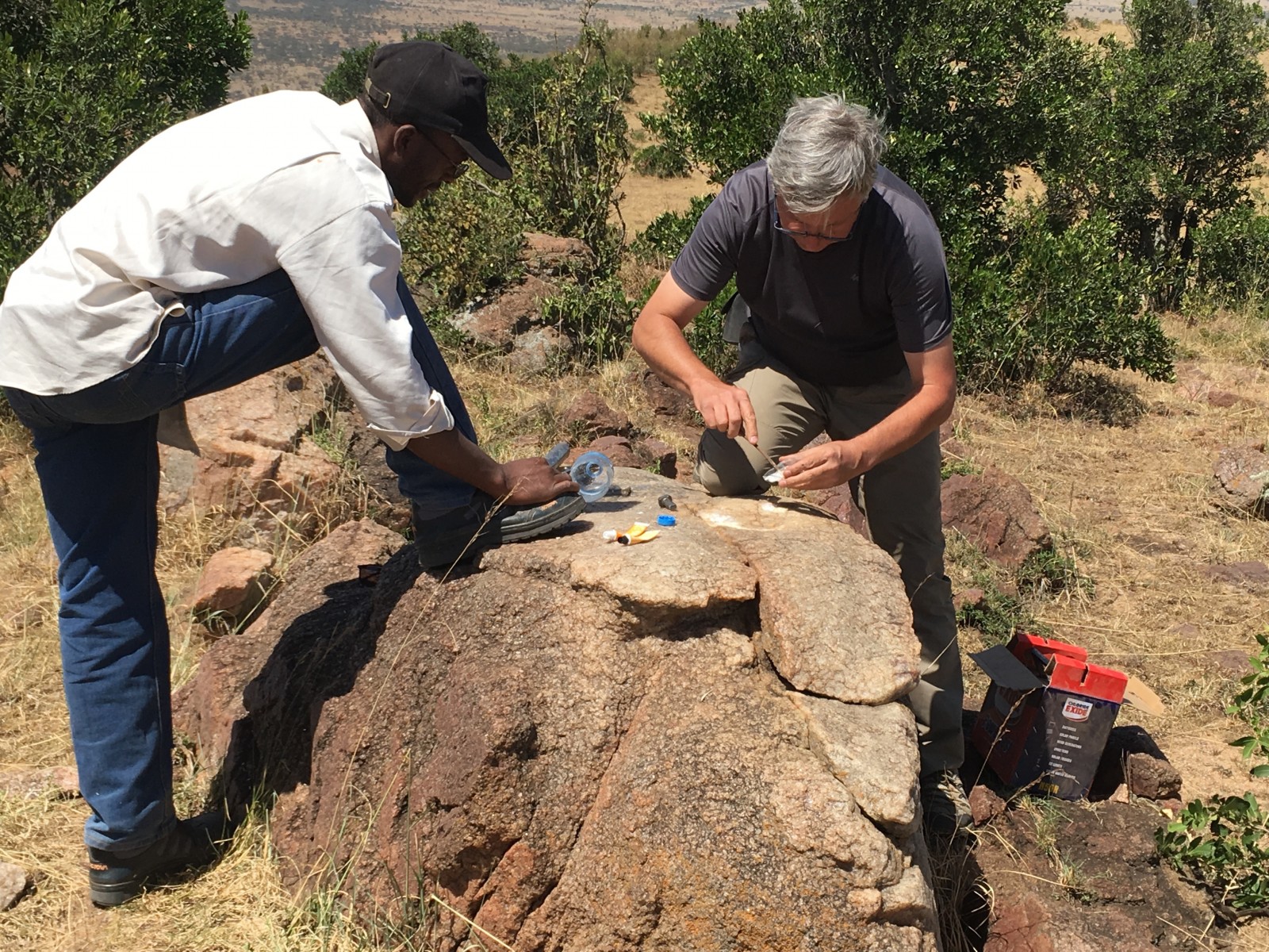
Installation of a geodetic benchmark for campaign GPS measurement, Klein’s Camp, Serengeti National Park, Tanzania. Credit: Eric Calais
There is always this back and forth in our field between more measurements and more models. Should we make more measurements? Or should we stop, stand back and think about what these measurements actually mean before we set up new instruments somewhere? I think that finding this balance is a challenge in a way, not only in Earth Sciences. Finding the right balance between, how much is invested into developing measurement systems and producing data and how much investment should be made into making sense of the data. At the moment, there is progress being made, but we are underestimating the data revolution in Earth Sciences.
Right now you hear about machine learning and big data and all those words are out and about in the Earth Sciences, as in any other science. But, we need to be much better prepared to what’s already there in terms of data and what is going to come. It’s very challenging to have not only the right algorithms and the code etc, but also the right mindset in place to accept that in the near future a lot of our thinking will be driven by data, perhaps more so than by physics – My colleagues will kill me for saying that (laughs). It’s a challenge and an opportunity.
I could have done something completely different and have been equally happy.
What were your motivating grounds starting as an Early Career Researcher? Did you always saw yourself staying in academia?
It’s important for the younger generation of ECR to realize that 25 years have made a big difference in terms of the job market, to begin with. When I was a PhD student in France, having done a postdoc was absolutely not mandatory to get a job. I did one, but a lot of my colleagues did not. Right now, most early career students go through 1, 2, 3, 4, 5 postdocs and it’s still hard to find a job. Things have changed dramatically.
My expectation was academia. There was nothing else to think about, really. I barely had a thought for a career in the private sector. It was so much driven by my passion and things were going fine, so I could not see myself doing something else. That being said, now, in retrospective, when I think about myself looking forward in terms of an academic career and nothing else, I know that I was wrong in the sense that I could have done something completely different and have been equally happy. The job I did in Haiti with the UN, for example, a few years ago opened my eyes. There are lots of great, fulfilling, and useful things to do as a geoscientist, or with a geoscientific background, outside of the pure academic domain.
There are lots of great, fulfilling, and useful things to do as a geoscientist […] outside of the pure academic domain. […] Be an actor of change, not just a scientist.
What advice would like to you give to Early Career Students?
I’m trying to stay away from the typical advice: be persistent, be creative. That is true, those are important… Both are easy to say, but not easy to do… One advice that I would give, that I was never given is: be a scientist who is a part of this planet. Be an actor of change, not just a scientist.
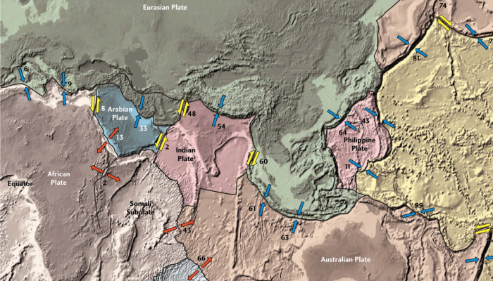
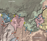
This map illustrates the horizontal surface motions of sites in Asia. Eric Calais, a Purdue associate professor of geophysics, used global positioning systems to measure the precise movements of hundreds of points on the continent to determine how they react to collisions of the underlying tectonic plates. (Purdue graphic/Calais laboratory) – Credit: Purdue University
Interview conducted by David Fernández-Blanco
Farokh
It is so nice interview. I try to translate to farsi