The region of the Earth’s atmosphere lying at altitudes between about 80 and 120 km, corresponding to the mesosphere–lower thermosphere–ionosphere (MLTI), is often referred to as the “ignorosphere”, because its observation is so challenging that only a handful of measurements of its composition, temperature and other physical parameters have been obtained over the last few decades. It is, however, a crucial region in terms of couplings between the upper atmosphere and the magnetosphere. Indeed, when charged particles precipitate from near-Earth space, they essentially deposit their energy in the MLTI, leading to the ionisation of neutral species, the dissociation of molecules, and the excitation of the atmospheric constituents producing auroral emissions. In addition, those precipitating particles carry electric currents along the magnetic field direction which are closed in the ignorosphere and lead to heating of the neutral gas via the friction between the ions (whose motion is driven by the horizontal electric fields) and the neutrals (who follow the high-altitude winds).
The study summarised here, led by Prof. Minna Palmroth (University of Helsinki, Finland), and whose results were recently published in AGU Advances, presents a new auroral form which may provide insight into the ignorosphere, brought to the attention of Prof. Palmroth by Finnish citizen scientists. This auroral form, named “the dunes” by Pirjo Koski, one of the citizen scientists, consists of a wave field of green auroral emissions exhibiting very regularly spaced “fingers” equatorwards from the main auroral arc. The fingers are roughly aligned in the north–south direction and are hence approximately perpendicular to the main arc. The chosen name comes from their resemblance with sand dunes in a desert.
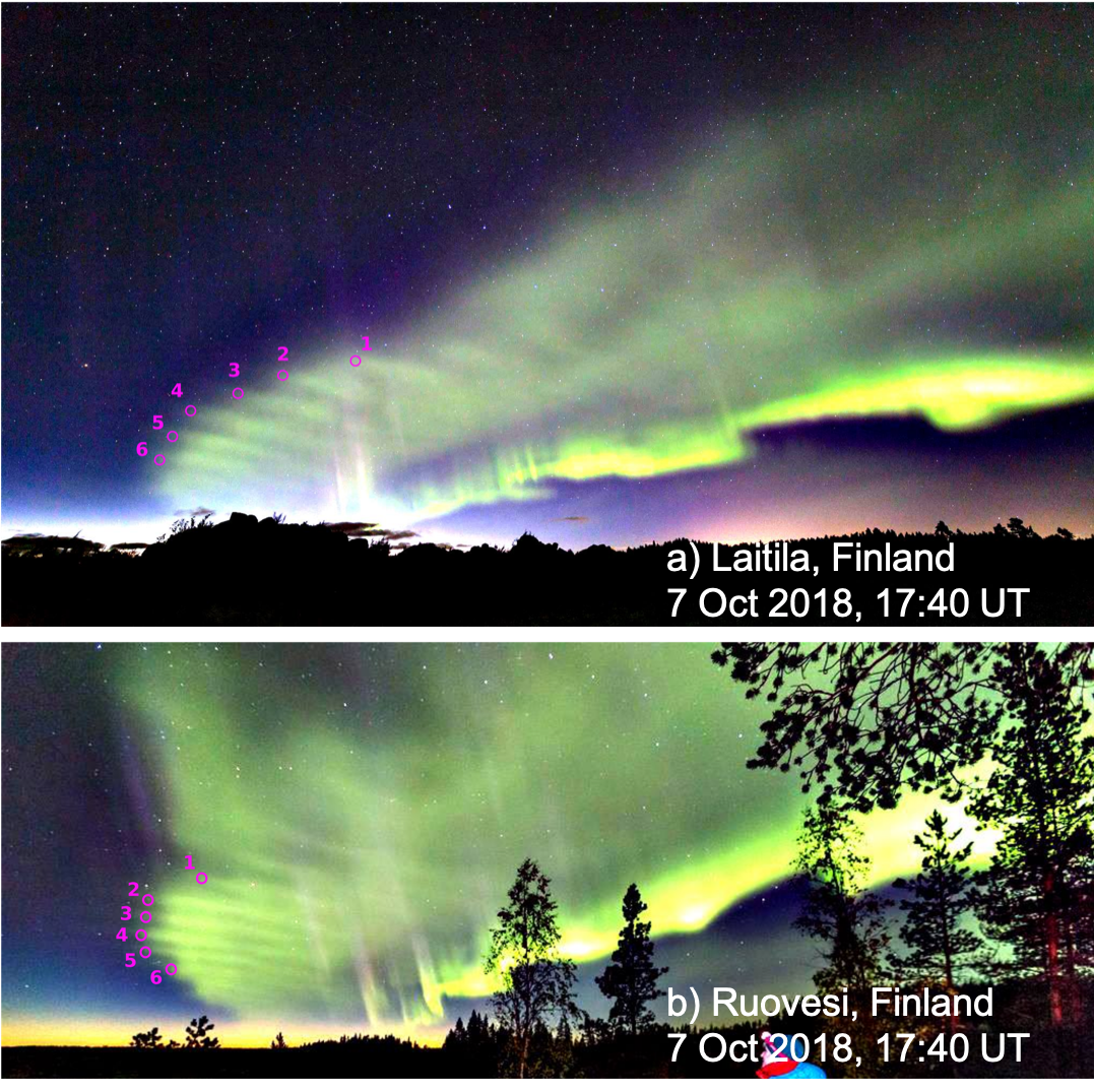
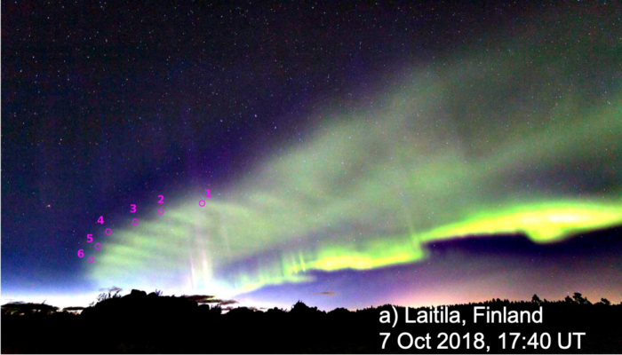
Two simultaneous pictures of the dunes on 7 October 2018 from (a) Laitila (by Pirjo Koski) and (b) Ruovesi (by Rami Valonen), where six fingertips were identified to determine their altitude. © Palmroth et al. (2020) / CC BY 4.0
This study of the dunes began in early October 2018, shortly after the publication of a book written by Minna to catalogue and explain the known auroral forms (Revontulibongarin opas, in Finnish) and resulting from a cooperation with many auroral photography enthusiasts across Finland, who submitted thousands of pictures to serve as illustrations for their book – about a hundred of which were selected. On 7 October 2018, two days after the book was released, Matti Helin, who was part of the core group of enthusiasts in the book writing process, noticed that the dunes were present in the sky and immediately contacted the other members of the team. This allowed Minna to supervise an impromptu observation campaign during which the citizen scientists were taking as many photographs of the auroral dunes as possible. Pictures were hence taken from four different locations in the southern half of Finland (Laitila by Pirjo Koski, Ruovesi by Rami Valonen, Siilinjärvi by Minna Glad, and Aura by Kari Saari) between 17:34 and 17:59 UT.
Luckily, two of those pictures were taken within the same second at 17:40:59 UT from Laitila and Ruovesi, which are separated by a distance of 172 km. This enabled Dr Maxime Grandin, a postdoctoral researcher in Minna Palmroth’s team at the University of Helsinki, to determine the altitude of the dunes as well as the wavelength of the associated wave field. Maxime identified the star constellations visible in the Laitila and Ruovesi pictures, which enabled him to determine which stars were located behind six dune fingertips that could be unambiguously identified on both pictures. With the help of the Stellarium software, well-known to amateur astronomers, he could hence obtain the azimuth and elevation of each dune fingertip in both pictures. Through the derivation of trigonometric equations, it was therefore possible to retrieve the altitude of the six fingertips from the knowledge of those angles. It appeared that the six dune fingertips were located at an altitude close to 100 km and that the wave field was horizontal. Once the altitude was known, it was possible to project the dunes onto the ground to determine their location and get an estimate of the distance between two dune fingers. The dunes observed from Laitila and Ruovesi were above eastern Sweden and exhibited a wavelength of the order of 45 km. Assuming the altitude to be the same for the dunes observed from Siilinjärvi a few minutes earlier (17:34 UT), these were mapped to the Gulf of Bothnia and the westernmost tip of Finland.

(a) Locations of the observation sites in Finland and mapping of the dunes seen from Laitila and Ruovesi (in red) at 17:41 UT and from Siilinjärvi (in purple) at 17:34 UT. The blue circle shows the field of view of the all-sky camera in Hankasalmi, projected at 100 km altitude. (b) Ionospheric vertical total electron content integrated from a three-dimensional GPS satellite tomography electron density reconstruction using data accumulated during 4 min. © Adapted from Palmroth et al. (2020) / CC BY 4.0
Alongisde the citizen scientists’ pictures, data from geophysical instruments were used to provide the context of the event. An all-sky camera from Hankasalmi captured the dunes, although at an earlier time (17:28 UT) due to the presence of clouds above Hankasalmi around 17:40 UT. The analysis of data obtained by ionospheric tomography, which is based on the propagation of radio-waves from GPS satellites through the ionosphere to ground based receivers., was performed by Johannes Norberg from the Finnish Meteorological Institute. The maps of total electron content in the ionosphere above Fennoscandia at 17:41 UT indicated an enhanced electron content at the location of the dunes. This suggests that the dunes are associated with the precipitation of electrons from near-Earth space, which is consistent with their auroral nature. Finally, data collected by ground-based magnetometers at various latitudes in Finland showed that the dunes occurred between a pair of field-aligned current systems and at a location where eastward horizontal currents, called electrojets, were present in the ionosphere, indicating a strong coupling of the ionosphere with the magnetosphere through electrodynamics.
The solar wind conditions, on the other hand, were fairly typical of those associated with a high-speed stream originating from a coronal hole at the solar surface: the solar wind speed was slightly above 500 km/s and the interplanetary magnetic field had a southward component of moderate magnitude, making conditions favourable to the production of geomagnetic disturbances. The dunes were indeed associated with a moderate geomagnetic storm.
By searching through the open Taivaanvahti observation service maintained by the Finnish Association for Amateur Astronomers (Ursa), the citizen scientists could identify 7 dune events recorded in Finland between 2015 and 2018. All of these cases took place during moderate geomagnetic storms (Kp = 5–7). The observers consistently reported that the dunes appear as a monochromatic wave field in the diffuse green aurora, faintly visible to the naked eye, southward (equatorward) from the main auroral arc. All 7 dune events reported in the study took place during evening hours and in the presence of a pair of field-aligned currents revealed by magnetometer data. All events but one were observed in October.
In the absence of satellite data observing particle precipitation patterns across the dune field, it is not possible to establish beyond a doubt that the auroral emission undulations are not associated with spatial inhomogeneities in the precipitation. However, the characteristics of the dune field (extending across a few hundred kilometres, dune separation of about 45 km, altitude near 100 km) suggest that the dunes could be associated with spatial inhomogeneities in the neutral atmosphere, and in particular in the atomic oxygen density which is responsible for the green auroral emission. Such inhomogeneities can be explained by the presence of atmospheric waves which modulate spatially the density of neutral species. In particular, one rare type of atmospheric wave exhibits characteristics which match those of the dunes fairly well. This type of wave is called a mesospheric bore.
Mesospheric bores are atmospheric waves which are able to produce a very regular horizontal wave field at altitudes corresponding to the upper mesosphere, near 80–100 km. When suitable conditions are met in the mesosphere, mesospheric bores can propagate across several hundred kilometres and produce atmospheric undulations at a wavelength of several tens of kilometres. Such conditions consist of either the formation of a temperature inversion layer or a strong wind shear below the mesopause (the upper limit of the mesosphere, generally located around 90–100 km). These features can serve as a wave guide which favours the propagation of the bore. Mesospheric bores have been reported to occur more frequently during evening hours and around the equinoxes, which is consistent with the dune events reported so far. They have not been previously observed at high latitudes, since their observation has so far been relying on airglow measurements, which typically cannot consider auroral latitudes to avoid contamination of the airglow signal.
In summary, the mechanism leading to the formation of auroral dunes suggested by the study is as follows. First, moderate geomagnetic storm conditions make the auroral oval expand to latitudes such as southern Finland. In particular, diffuse aurora is observed equatorward from the main arc. Second, the presence of a temperature inversion layer or strong wind shears in the upper mesosphere creates suitable conditions for a mesospheric bore to propagate at the latitudes affected by the auroral precipitation. When propagating across large distances, the mesospheric bore produces undulations in the atomic oxygen density near the mesopause (close to 100 km altitude), with a wavelength of several tens of kilometres. The undulating field of atomic oxygen is then excited by the precipitating particles and produces green auroral emissions which correspondingly exhibit spatial modulations. The rarity of mesospheric bores combined with that of suitable geomagnetic conditions and the regular presence of a cloud cover preventing auroral observations can explain why the dunes are not a very frequent phenomenon.
One open question raised by the article is to determine whether the energy deposition into the upper atmosphere during geomagnetic events could create suitable conditions for mesospheric bores to propagate, or whether the bore simply happens to be present when the diffuse aurora illuminates it. Additional studies will be needed to confirm or refute the explanation of the auroral dunes in relation with mesospheric bores, as other processes such as a spatial modulation of precipitating particle fluxes could in theory also lead to the observed auroral emission patterns.
Finally, one major take-home message from this study is that we have now entered an era when citizen scientists can produce invaluable data sets to help researchers understand poorly known regions such as the ignorosphere. The auroral photographs presented in this study enabled the scientists to retrieve the altitude and characteristics of the dunes, which would not have been possible without the involvement of the citizen scientists from southern Finland, as most geophysical instruments for auroral studies (all-sky cameras, photometers, incoherent scatter radars) are located further north in Fennoscandia, at geomagnetic latitudes corresponding to the average latitude of the auroral oval. Following the discovery of the STEVE (Strong Thermal Emission Velocity Enhancement) optical phenomenon by Canadian citizen scientists a couple of years ago, it is becoming clearer and clearer that citizen science has a strong potential for the advancement of the understanding of nature.