For this Earthquake Watch we are very pleased to have a contribution about the 2025 Santorini – Amorgos seismic sequence, by Dr. Andreas Karakonstantis, a postdoctoral researcher at the University of Patras and National and the Kapodistrian University of Athens. He obtained his Ph.D. in seismology in 2017.
Does life move in circles? That is an excellent question to ask, especially in our case regarding the earthquakes in the broader area of Santorini-Amorgos. Why so much noise, though? What is the particular interest in this area? Let me explain this issue in the following section.
Santorini Island Volcanic Complex (SIVC)
We know that the area is part of the Southern Aegean Volcanic Arc (SAVA), with the volcanoes of Sousaki, Aegina, and Methana-Poros in its NW end (Central Greece), and Nisyros-Kos at its eastern termination, near the western shores of Turkey accompanying Kameni and Columbo volcanic centres (Figure 1).
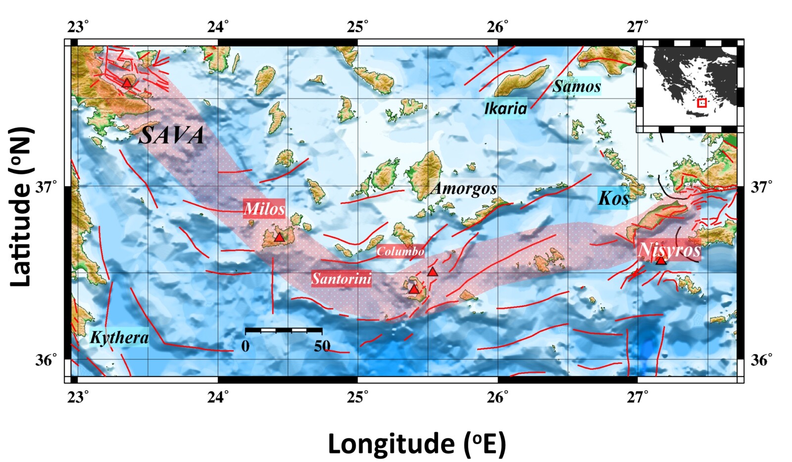
Figure 1. Main tectonic features in Southern Aegean. Abbreviations—SAVA: South Aegean Volcanic Arc. Fault traces (red lines) were modified after Papadimitriou et al. (2015).
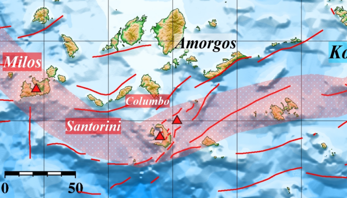
Santorini is in the central part of SAVA, making an excellent example of applying various methods to investigate the local volcanotectonic elements. The island is characterized by a multi-center volcanic field which is intersected by a flooded caldera, one of the world’s most violent volcanoes of this category (Drymoni et al. 2022). On the other hand, the Columbo line controlled the vent position of two major explosive events as well as dyke swarm, cinder cones, and Cape Columbo tuff ring on the northern part of Thira (Vougioukalakis et al. 2005) (Figure 2).
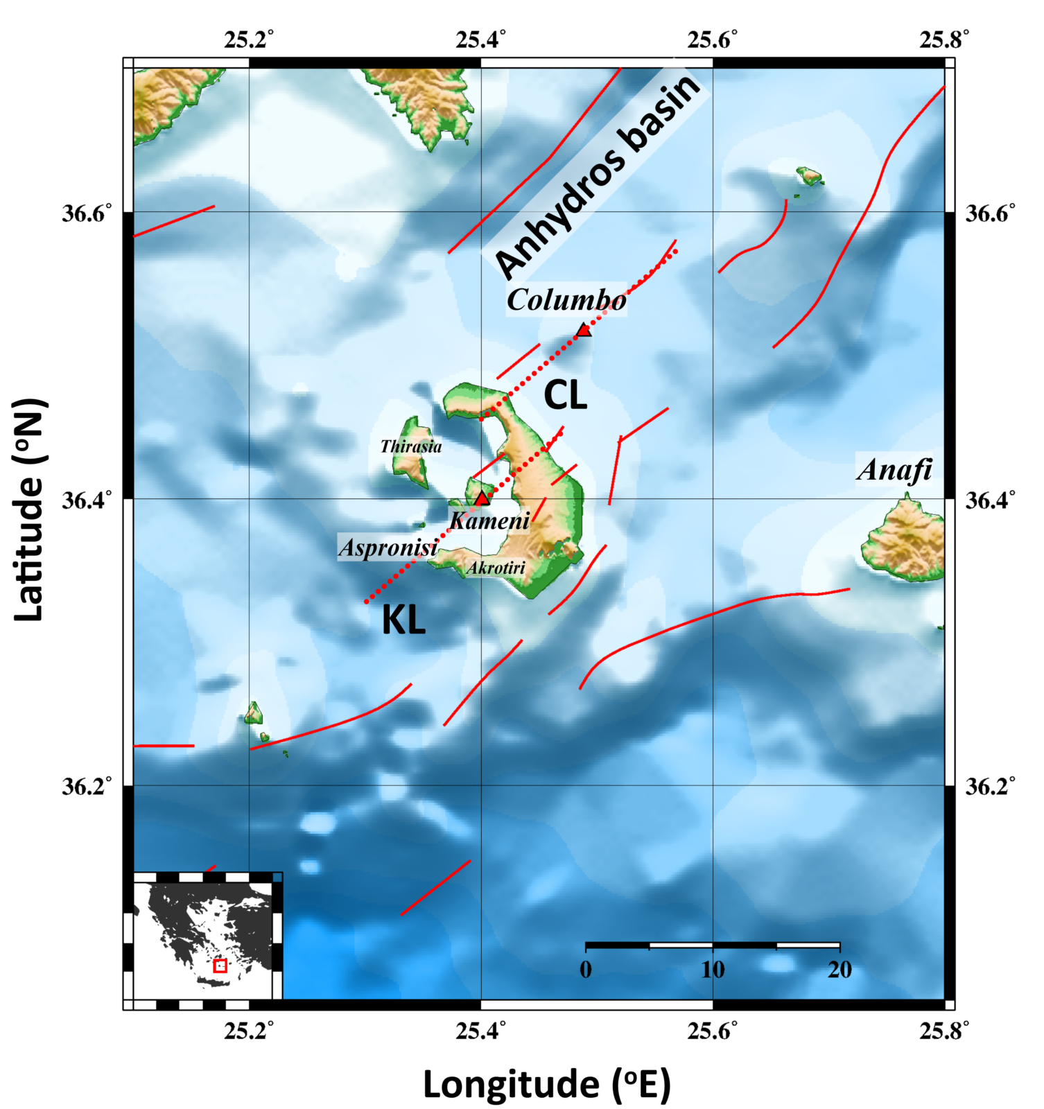
Figure 2. Main tectonic features in the broader area of Santorini Volcanic Complex. The red triangles represent the active volcanic centers of the area. Fault traces (red lines) derived by Sakellariou et al. (2017) and Nomikou et al. (2018).
The broader area of the Southern Aegean has been affected by numerous earthquakes throughout historic times, mainly due to its tectonic setting along the Hellenic Arc. This seismic zone is one of the most active in the Mediterranean. The most notable events during the relatively recent (in geological time frame) period are the following:
- 1650 Columbo Volcanic Eruption: The trembling from the volcanic eruption caused widespread damage to Santorini and resulted in tsunamis that hit surrounding areas (Konstantinou 2020).
- 1707, when an earthquake associated with an eruption occurred and the activity ended in September 1711, creating Nea Kameni (Papazachos and Papazachou 1997).
- The 1956 Amorgos Earthquake, with a magnitude of 7.7, was one of the most devastating in modern times (Konstantinou 2010).
These earthquakes and numerous smaller quakes constantly remind us of the region’s ongoing seismic and volcanic activity. This activity, which has significantly shaped the island’s history, has garnered the attention of the entire geoscientist community in the Southern Aegean region.
Is the current swarm the first incident after the 1956 Amorgos event?
No. A similar pattern of seismic activity is observed NE of Columbo, constantly in time, with small-scale activity spots that may indicate local pathways of upward migrating fluids (Bohnhoff et al. 2006). Dimitriadis et al. (2009) suggest that the observed seismicity underneath Columbo is associated with the Kameni–Columbo line, which corresponds to the western termination of the major Santorini-Amorgos Fault Zone to the NE. Further on, they suggest that the NE Santorini – Columbo faults belong to a single rupture system. The tomographic study of Dimitriadis et al. (2010) identified a low-velocity zone of body waves between 5 and 7 km in the northeastern part of Santorini Island, in agreement with the local tectonic regime. The direction of this zone coincides with the faults of the “Kameni-Columbo” line. The authors couldn’t exclude a connection between the surface intracalderic volcanic rocks and a deeper (>10km depth) magmatic chamber beneath Columbo.
In September 2011, a seismic unrest period began changing the seismic pattern of the SVC (Figure 3). The initiation of the intense activity caused damage to the local infrastructure, as the local authorities reported it and thoughts on the volcano’s status—a high-resolution relocation of the intracalderic seismic events connected that activity with the Kameni line ( Papadimitriou et al. 2015). The focal depths ranged between 2 and 8 km.
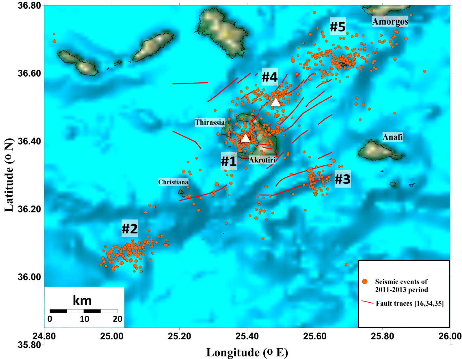
Figure 3. Distribution of the most important earthquake clusters identified between 2011 and 2013 (Karakonstantis and Vallianatos, 2024). White triangles represent the active volcanic centers, and the red lines represent the mapped fault traces derived by Sakellariou et al. (2017) and Nomikou et al. (2018).
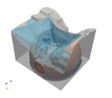
From this dataset, the top of the magmatic chamber was constrained through Local Earthquake Tomography in the study of Papadimitriou et al. (2015) (Figure 4).
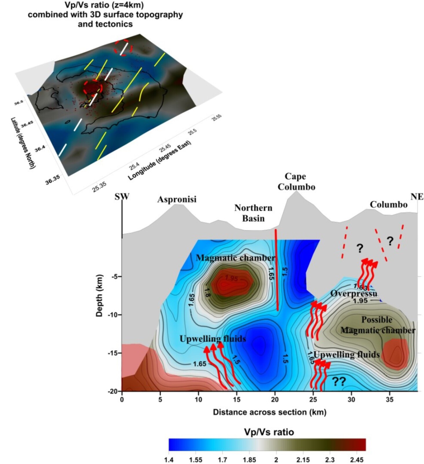
Figure 4. Distribution of Vp/Vs for the cross-section with azimuth N35oE from Christana island to Columbo-Amorgos basin (Papadimitriou et al. 2015).
Did the 2025 activity in the area of Amorgos start abruptly?
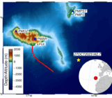
No, we have had a gradual increase in seismicity rates since August 2024 in both the intracalderic area and the Columbo-Amorgos basin. Since October, the activity has climbed from a few dozen events to nearly 100 earthquakes monthly, with M≥2.0, escalating with the occurrence of the Thiressia M3.8 earthquake (January 25, 2025) near the Mogi source area that was identified in the 2011-2012 unrest (Figure 5).
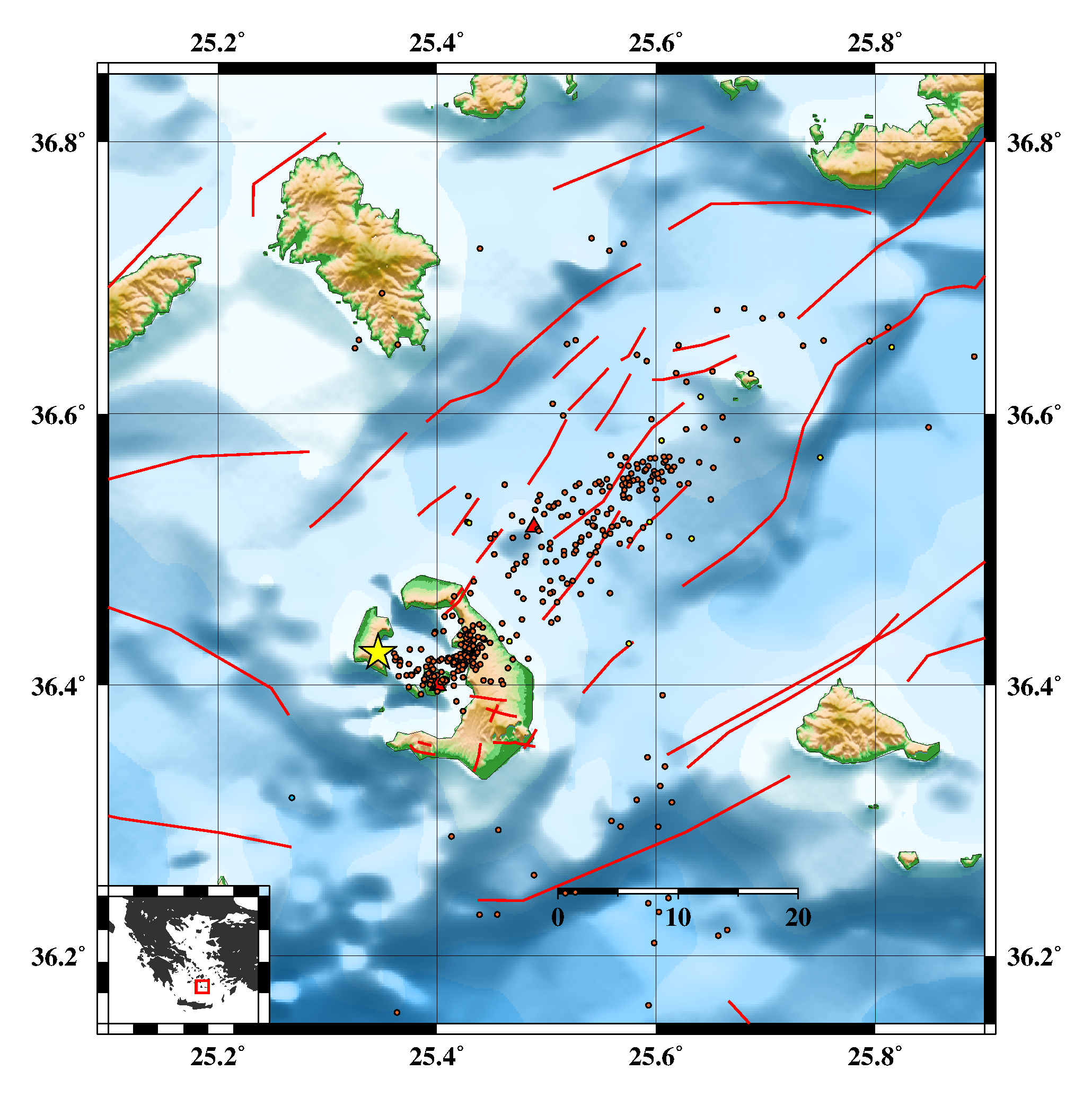
Figure 5. Manually located events for the time period from January 2024 to January 2025 (Seismological Laboratory of the NKUA; http://www.geophysics.geol.uoa.gr/) Noted by yellow star the M3.8 earthquake in Thirassia (2025-01-26).
…And here we go!
February welcomed us in a truly bizarre way! Since the first one of M3.9, more earthquakes of similar size followed, peaking in a M5.2 seismic event on February 10, 2025. Fortunately, the components of the Hellenic Unified Seismological Network (HUSN; Evangelidis & Melis, 2012) have begun the upgrade since February 02, installing seismological and geodetic stations in the broader area, which resulted in a much better event distribution in both horizontal (epicentres) and vertical (hypocentres) view (Figure 6). All the events occurred in an area broken down by a series of small to medium-sized faults (Ganas, 2022), resulting in swarm-like activity throughout the period of interest (January 24 – February 26, 2025).
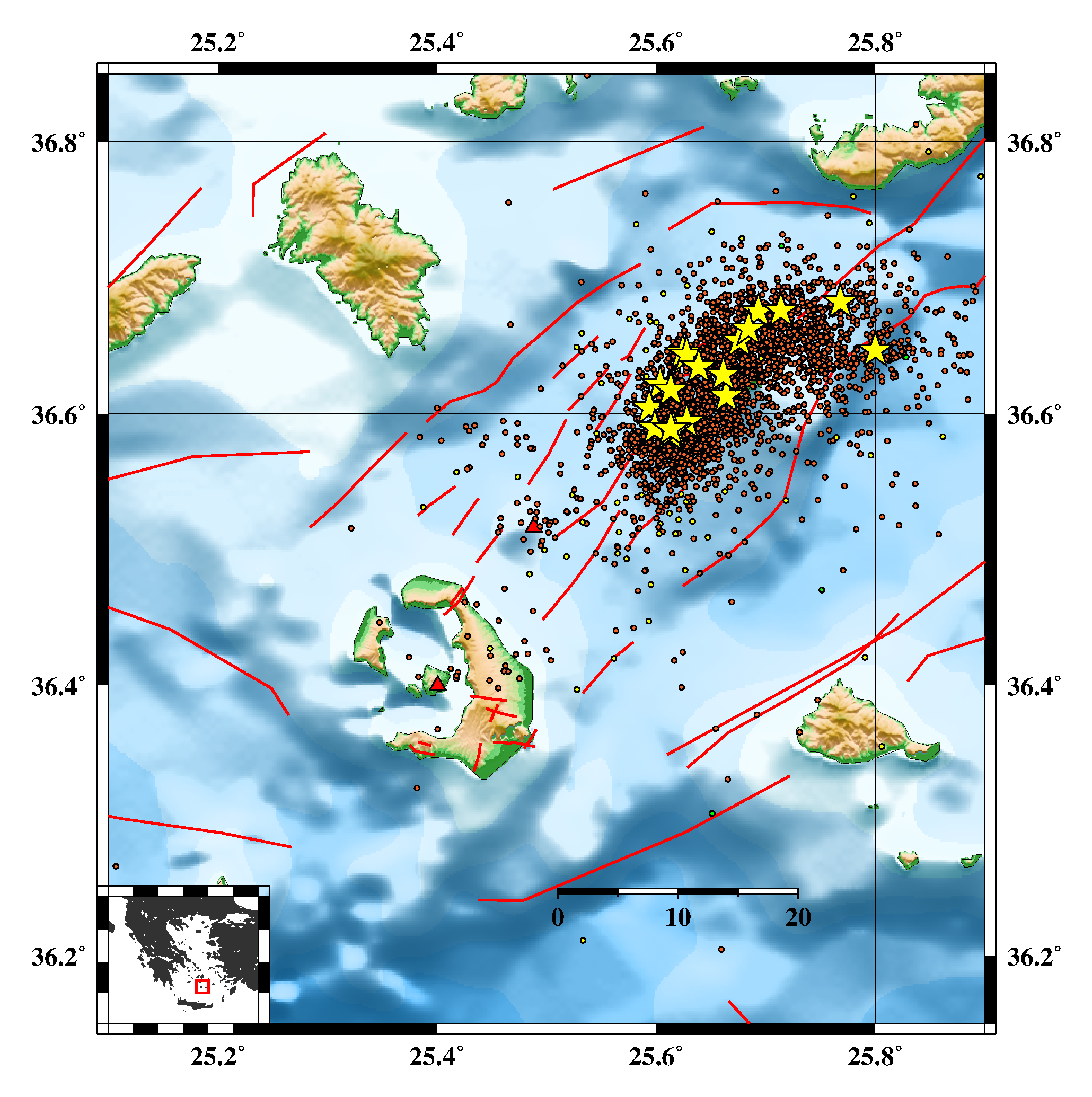
Figure 6. Manually located events for the time period from February 2025 to March 4, 2025 (Seismological Laboratory of the NKUA; http://www.geophysics.geol.uoa.gr/) Noted by yellow stars the M≥4.8 earthquakes in the area.
Many colleagues have raised concerns about an upcoming larger event, which eventually would make the efforts of the Ministry of Civil Protection. However, since this day (early March 2025), the rates have gradually decayed with smaller magnitudes with peak values of M3.6-3.7 (Figure 7).
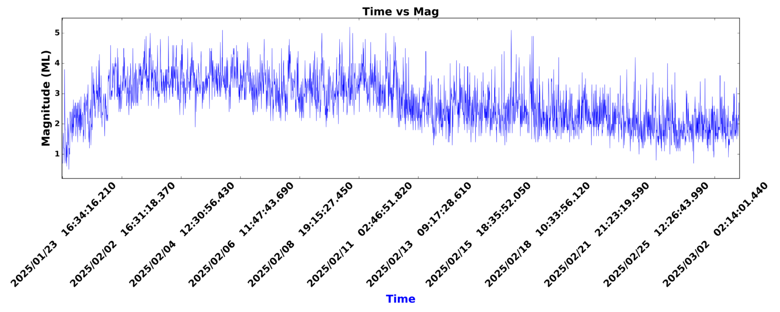
Figure 7. Time-Magnitude plot of the manually located events for the time period from January 23 – March 4, 2025 (Seismological Laboratory of the NKUA; http://www.geophysics.geol.uoa.gr/).
The seismic activity is mainly concentrated in a depth range between 4 and 16 km, with both the south and north-dipping structures of NE-SW orientation appearing activated throughout the time period. Around mid-February, a distinct spatial cluster appeared closer to the southern shores of Amorgos Island, mainly connected to the M4.7 earthquake that took place on February 11, 2025, at 05:58:46 UTC. Does it mean that we may have an activation of the fault that resulted in the 1956 M7.7 earthquake? None of the data we have analyzed so far in the Seismological Lab shows anything that could make us more suspicious (b-value distribution, Coulomb stress analysis, etc.). That was the main reason for applying artificial intelligence (AI) methods to locate earthquakes of smaller magnitude. Since the start of seismic, the Seismology Laboratory (SL) of the University of Athens (http://dggsl.geol.uoa.gr/) has detected and located over 25,000 earthquakes using machine learning methods, of which over 21,000 with magnitudes M≥1.0.
Do we have any signs of a connection between this swarm and the volcanic centres of Kameni and Columbo?
Apart from the activity with small to intermediate magnitude (M≤3.3) earthquakes, both in the intracaldera area and around Columbo, which extends throughout the entire period of the eruption (January 03 – March 04 2025), the area doesn’t experience exceeding background seismicity rates. The analysis of the spectral content carried out daily by the Seismology Laboratory of the National and Kapodistrian University of Athens (Figure 8) shows that these mainly belong to the category of tectonic earthquakes for earthquakes with M>2.6, while some of smaller magnitudes seem to be marginally included (and with any uncertainties) in the category of VT-A (volcanotectonic A-type) events, which take place on the Kameni – Columbo line ~10 km NE of Santorini in shallow depths (2-12 km). The current analysis of Vp/Vs ratio (~1.76) through Wadatti diagrams in the preliminary data does not imply a significant change in the fluid circulation since 2013.
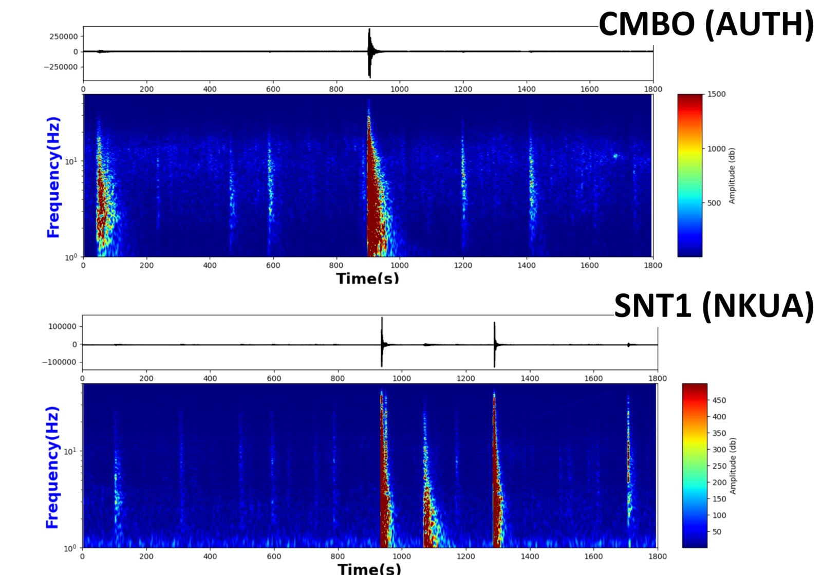
Figure 8. 30-min spectrograms in the stations of Columbo (CMBO; AUTH) and Gialos (SNT1; NKUA) for the earthquakes occurring in February-March, 2025.
Concerning the million-dollar question: Will we experience an eruption in either of these centres (Kameni-Columbo)?
The answer is more complicated than people want or at least hope to hear: The ongoing analysis of the earthquake activity does not indicate such a thing; therefore, the chances are considered relatively low. This does not mean that the picture cannot change abruptly. Volcanic systems are dynamic, and the chances for the genesis of such an event can change significantly if, from a seismological point of view, a predominantly low-frequency seismic activity begins and the gradual transition from tectonic and volcano-tectonic (A and B type) to low-frequency (e.g. hybrid type) earthquakes in more superficial parts of the crust ( < 2 km).
The guest post authored by Dr Andreas Karakonstantis, edited by Dinko Sindija and Adam Ciesielski (from blog team).
References
- Dimitriadis, I.; Karagianni, E.; Panagiotopoulos, D.G.; Papazachos, C.; Hatzidimitriou, P.; Bohnhoff, M.; Rische, M.; Meier. T. Seismicity and active tectonics at Coloumbo Reef (Aegean Sea, Greece): monitoring an active volcano at Santorini Volcanic Center using a temporary seismic network. Tectonophysics, 465, 2009, 136-149
- Dimitriadis, I.; Papazachos, C.; Panagiotopoulos, D.; Hatzidimitriou, P.; Bohnhoff, M.; Rische, M.; Meier, T. P and S velocity structures of the Santorini–Coloumbo volcanic system (Aegean Sea, Greece) obtained by non-linear inversion of travel times and its tectonic implications. J. Volcanol. Geotherm. Res. 2010, 195, 13–30.
- Drymoni, K.; Browning, J.; Gudmundsson, A. Spatial and temporal volcanotectonic evolution of Santorini volcano, Greece. Bull. Volcanol. 2022, 84, 60.
- Evangelidis, C. P. and N. S. Melis. Ambient Noise Levels in Greece as Recorded at the Hellenic Unified Seismic Network. Bulletin of the Seismological Society of America 2012;; 102 (6): 2507–2517. doi: https://doi.org/10.1785/0120110319
- Ganas, A. NOAFAULTS KMZ layer Version 4.0 (V4.0) [Data set]. Zenodo. 2022. Available online: https://zenodo.org/record/6326260#.Yoy6xlRBxN0 (accessed on 13 January 2022).
- Konstantinou, K. Crustal rheology of the Santorini–Amorgos zone: Implications for the nucleation depth and rupture extent of the 9 July 1956 Amorgos earthquake, southern Aegean. J. Geodyn. 2010, 50, 400–409.
- Konstantinou, K.I. Magma chamber evolution during the 1650 AD Kolumbo eruption provides clues about past and future volcanic activity. Sci. Rep. 2020, 10, 15423.
- Nomikou, P.; Hübscher, C.; Papanikolaou, D.; Farangitakis, G.; Ruhnau, M.; Lampridou, D. Expanding extension, subsidence and lateral segmentation within the Santorini–Amorgos basins during Quaternary: Implications for the 1956 Amorgos events, central–south Aegean Sea, Greece. Tectonophysics 2018, 722, 138–153.
- Papadimitriou, P.; Kapetanidis, V.; Karakonstantis, A.; Kaviris, G.; Voulgaris, N.; Makropoulos, K. The Santorini Volcanic Complex: A detailed multi-parameter seismological approach with emphasis on the 2011–2012 unrest period. J. Geodyn. 2015, 85, 32–57.
- Papazachos, B.C.; Papazachou, C. The Earthquakes of Greece; Ziti Publications: Athens, Greece, 2003.
- Sakellariou, D.; Sigurdsson, H.; Alexandri, M.; Carey, S.; Rousakis, G.; Nomikou, P.; Georgiou, P.; Ballas, D. Active Tectonics in the Hellenic Volcanic Arc: The Kolumbo Submarine Volcanic Zone. Bull. Geol. Soc. Greece 2017, 43, 1056.
- Vougioukalakis, G.E.; Fytikas, M. Volcanic Hazards in the Aegean Area, Relative Risk Evaluation, Monitoring and Present State of the Active Volcanic Centers. In The South Aegean Active Volcanic Arc, Development in Volcanology; Fytikas, M., Vougioukalakis, G.E., Eds.; Elsevier: Amsterdam, The Netherlands, 2005; Volume 7, pp. 161–183.
- National Observatory of Athens, Institute of Geodynamics, Athens. National Observatory of Athens Seismic Network [Data set]. International Federation of Digital Seismograph Networks. 1975. Available online: https://www.fdsn.org/networks/detail/HL/ (accessed on 05 March 2025).
- University of Athens. Hellenic Seismological Network, University of Athens, Seismological Laboratory [Data Set]. International Federation of Digital Seismograph Networks. 2008. Available online: https://www.fdsn.org/networks/detail/HA/ (accessed on 05 March 2025).
- Aristotle University of Thessaloniki. Aristotle University of Thessaloniki Seismological Network [Data Set]. International Federation of Digital Seismograph Networks. 1981. Available online: https://www.fdsn.org/networks/detail/HT/ (accessed on 05 March 2025).
- Institute of Engineering Seismology Earthquake Engineering (ITSAK), Greece. 1981. Available online: https://www.fdsn.org/networks/detail/HI/ (accessed on 05 March 2025).
- University of Patras, Seismological Laboratory, HP. 2000. Available online: https://www.fdsn.org/networks/detail/HP/ (accessed on 05 March 2025).
- Hellenic Mediterranean University Research Center (Former Technological Educational Institute of Crete). Seismological Network of Crete; 10.7914/SN/HC; International Federation of Digital Seismograph Networks: Crete, Greece, 2006 (accessed on 05 March 2025).