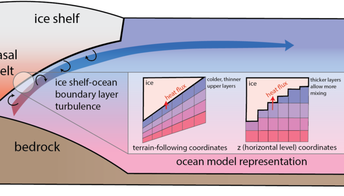
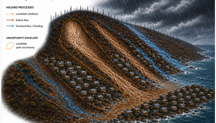
Antarctic ice shelves melt from beneath where they contact the ocean, but how well do ocean models simulate this process? Building on several decades of model development, a recent model intercomparison study compared ice shelf-ocean models from modelling groups around the world with the same, idealised benchmark configuration. From this effort, we can learn how current models perform, and how we ...[Read More]
Geodesy
From Quasars to Coordinates: How VLBI Measures Earth’s Shape and Motion
Imagine determining the position of a point on Earth with millimeter precision using radio signals from celestial objects billions of light-years away. This may sound like science fiction, but it is exactly what Very Long Baseline Interferometry (VLBI) allows scientists to do. What is VLBI? Long before satellites and digital maps, people looked to the sky and used celestial objects—most commonly t ...[Read More]
Geodynamics
Introducing the new blog team!
Hello blog readers! It’s Jean-Baptiste and Alexis. With EGU26 now behind us and summer approaching fast, we wanted to announce the start of the 9th blogging season for the Geodynamics division and introduce the team for the 2026–2027 year. We both have the privilege and the daunting challenge of succeeding Constanza and Michael as Editors-in-Chief of the Geodynamics Blog. Over the past three years ...[Read More]
Hydrological Sciences
Meet your ECS Rep – Archita Bhattacharyya
Archita Bhattacharyya is an Environmental Scientist and a research and development fellow at the Department of Environment, Food and Rural affairs, England. For 2026, she is the Early Career Scientist Representative for the Hydrological Sciences division. Can you tell us about the focus of your research? In my PhD, I focused on groundwater microbiology, especially how microbial communities change ...[Read More]
Hydrological Sciences
Dialogue is essential for advancing hydrological science
A little over a decade ago, a group of us argued that “it takes a village to raise a hydrologist”. The skills and knowledge any hydrologist should be exposed to during their training goes far beyond what a single person can do and know. Even more, the experience of how water shapes and interacts with diverse landscapes all around the world cannot be obtained by a single person. This is true especi ...[Read More]
Geodynamics
Modeling the full spectrum of observed seismicity: Insights from friction laws, fault instability, and fault-zone mechanics
Introduction Despite advances in our understanding of rock mechanics, the frictional behavior of rocks, and the physics of instability in geological materials, the coexistence of slow and fast earthquakes, as well as various types of fault-zone seismic radiation such as tremor, remains enigmatic. Can fault mechanics and friction laws reproduce the full spectrum of observed seismicity? In this week ...[Read More]
Ocean Sciences
Book Review: The Swarm by Frank Schätzing
So far, our reading adventures have kept us close to reality with Blue Machine by Helen Czerski and Below the Edge of Darkness by Edith Widder. Now, we are turning to a work of fiction. The author did plenty of research and spoke with scientists, who even appear as characters in the book, resulting in the science-fiction eco-thriller The Swarm. For centuries, humans have treated the ocean as a res ...[Read More]
Natural Hazards
When multiple hazards interact and the data doesn’t: The multi-hazard modelling problem nobody wants to talk about
There is a quiet contradiction at the heart of natural hazard science. The regions most exposed to multi-hazard events are precisely the regions where we know the least. The Global South (comprising lower- and middle-income countries in Africa, Asia, Latin America and the Caribbean) is disproportionately affected by climate-related natural hazards, yet it is largely underrepresented in climate res ...[Read More]
Cryospheric Sciences
The Arctic’s Blind Spot: Why Satellites Struggle Where Ice Meets the Coast
The first time I stood on sea ice, I could not tell which direction the coast was. A community member named Bryan could. That gap in situational awareness, between what a trained remote sensing scientist could read from the landscape and what a local hunter understood instinctively, turned out to mirror almost exactly the gap in our satellite data: ICESat-2 produces reliable freeboard across the c ...[Read More]
Geodesy
Geodesy Cartoons – A Creative Tool for Outreach and Education
Geodesy is fundamental to understanding our dynamic planet. From monitoring sea-level rise and glacier melt to maintaining precise terrestrial reference frames for GNSS and Earth observation, geodesy provides the scientific backbone for many disciplines represented within the EGU and beyond. Despite its importance, geodesy often remains invisible outside the scientific community. Even within geosc ...[Read More]