
The Mediterranean Sea has long been known to warm much faster than the global ocean. Within it, the Adriatic Sea is a particularly sensitive basin – due to its small size, representing 5% of the area and only 1% of the volume of the Mediterranean, it reacts rapidly to changes in air-sea interactions, precipitation and riverine input. It’s also one of the few locations in the Mediterranean where deep water is renewed due to cold and dry bora wind, which in turn brings oxygen to the deep layers of the Eastern Mediterranean.
Our previous studies showed that some processes have changed or appeared for the first time in the past 15-20 years. The question was whether we could address several of them systematically by combining 75 years of historical measurements with modern autonomous platforms, and so follow how they evolved over a longer time span.
For that we used over 33 thousand temperature and salinity profiles from 1950 to 2025, from ships and Argo floats combined. Argo floats are autonomous instruments that drift at depth and rise to the surface by changing their buoyancy every five to ten days, measuring on the way up and transmitting their data through satellites. The global network has collected more than three million profiles since the early 2000s, and the Mediterranean Sea has also been well covered – about 86 000 profiles since 2001. Argo data have greatly improved our understanding of several key ocean processes and the ocean’s role in regulating the climate. However, combining different observational platforms requires some caution, from quality-controlling and harmonizing the data, to the interpretative side: different instruments measure at different depths, with a different temporal frequency, and may be concentrated in certain months. Any spatial or seasonal aggregation therefore requires checking for such inconsistencies that might affect results.
The 21st century warming and salinification are present throughout the entire water column, with warming amplified with depth
Two long-term averages were compared: the second half of the 20th century 1950-1999 and the 21st century 2000-2025, showing that both the northern and the southern Adriatic warmed and salinified along the entire water column for all seasons, with a few exceptions due to different sampling months and locations. The southern Adriatic became saltier at every depth and season (by 0.11 to 0.53) and warmer by up to 1.6 °C. The northern Adriatic warmed by up to 3.0 °C at 20 m and salinified by up to 1.00 at the surface, both in summer, although these numbers should be treated with caution because many of the historical profiles were taken at the same few locations, which introduces a bias.
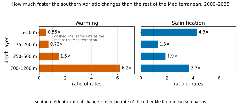
When looking at the linear trends of the past 25 years, a few results stand out: below 700 m the southern Adriatic warms 6.2 times faster than the median of the other Mediterranean sub-basins ( et al., 2026), with warming increasing progressively with depth. By contrast, above 200 m its warming is not amplified and is in line with the trends of the entire Mediterranean. Salinification is 3.7 times faster below 700 m and 4.3 times faster in the surface layers. Part of that surface number, however, reflects where the casts were taken rather than a change in the sea itself: near the surface the open sea is saltier than the shelf, and the recent casts, mostly from Argo floats, come from the open sea, whereas the older ship casts also covered the shelf. Nevertheless, when only open-sea casts are compared, the surface salinification is still 3.4 times faster than in the rest of the Mediterranean.
Salt has a dominant role in dense water formation
Why would the deep layers change much faster than the surface? One part of the answer lies in how the deep water is renewed, and in what the extra salt does once it is there.
The dense water is formed in the shallow northern shelf during cold and dry bora winds in winter. The water becomes dense, sinks and flows along the bottom into the southern basins, bringing oxygen. As we (Terzić et al., 2025a) and other colleagues (Le Meur et al., 2025) have shown in our previous works, since 2017, the mechanism has changed. In 2017, 2018 and 2022, when dense waters did form, they came from very salty water that was only weakly cooled. In 2018 and 2022 the winter heat loss was weaker than the 1980-2010 average, which suggests that another mechanism is at play in the last decade.
Such changes may have serious consequences: each renewal used to make deep layers colder, but since 2017 it leaves them warmer and saltier. The results of our paper are consistent with this mechanism and with the fast deep warming observed from the linear trends in 2000-2025.
Cascading is not the only way that salt may reach the deep layer. What we quantified is that the conditions for salt transport have strengthened below the classical intermediate salty layer originating from the Eastern Mediterranean. Warm salty water lying over cooler and fresher water can set off small-scale mixing driven by the salt itself – a mechanism known as salt fingering. In the southern Adriatic, the change is clearest at 600–1000 m, where the share of levels in which the fingers actually carry salt more than tripled since 2017, and the result is in line with the findings based on mooring data (Amorim et al., 2024) in the same region. The stratification there, that is the stability of the water column, has weakened, so the salt leaving the intermediate layer meets a water column able to carry it further down. In this work we have not measured fluxes, so this process remains a hypothesis.
The emergence of salty layers at the surface
The extra salt also shows up at the surface, in a form that was until recently almost unknown in the Adriatic. The so-called “surface saline lakes” are layers at the top of the sea that are saltier than the water beneath, the reverse of the usual picture. Such layers are thought to form during summer, when evaporation adds salt at the surface while strong warming keeps that water light. Salt makes water denser, so such a layer would normally sink and mix away. Here it stays in place because the surface water is so warm that it remains lighter than the water below, despite the extra salt. In our previous work (Terzić et al., 2025b) we showed that such features have become widespread in the Mediterranean Sea, unlike the literature analysing historical data from the 20th century (Manca et al., 2004), which has placed them only in the Levantine basin throughout the year and in the southern Ionian during summer and autumn months. This time we combined both Argo and ship measurements, which extends the analysis to the years before 2010, when there were no Argo floats in the southern Adriatic. One of the main caveats was that many old profiles were too coarse to detect such thin layers, so we compared only profiles of similar resolution. On these profiles, such features were rare in the southern Adriatic before 2014, but after 2014 about 38% of the June–October profiles (the period when most saline lakes occur) show such layers, against about 5% before, a more than sevenfold increase. Even among the old profiles that could have detected them, the layers were rare: 2.1% of the profiles of the 1990s, against 19% in 2016–2025, all months counted.
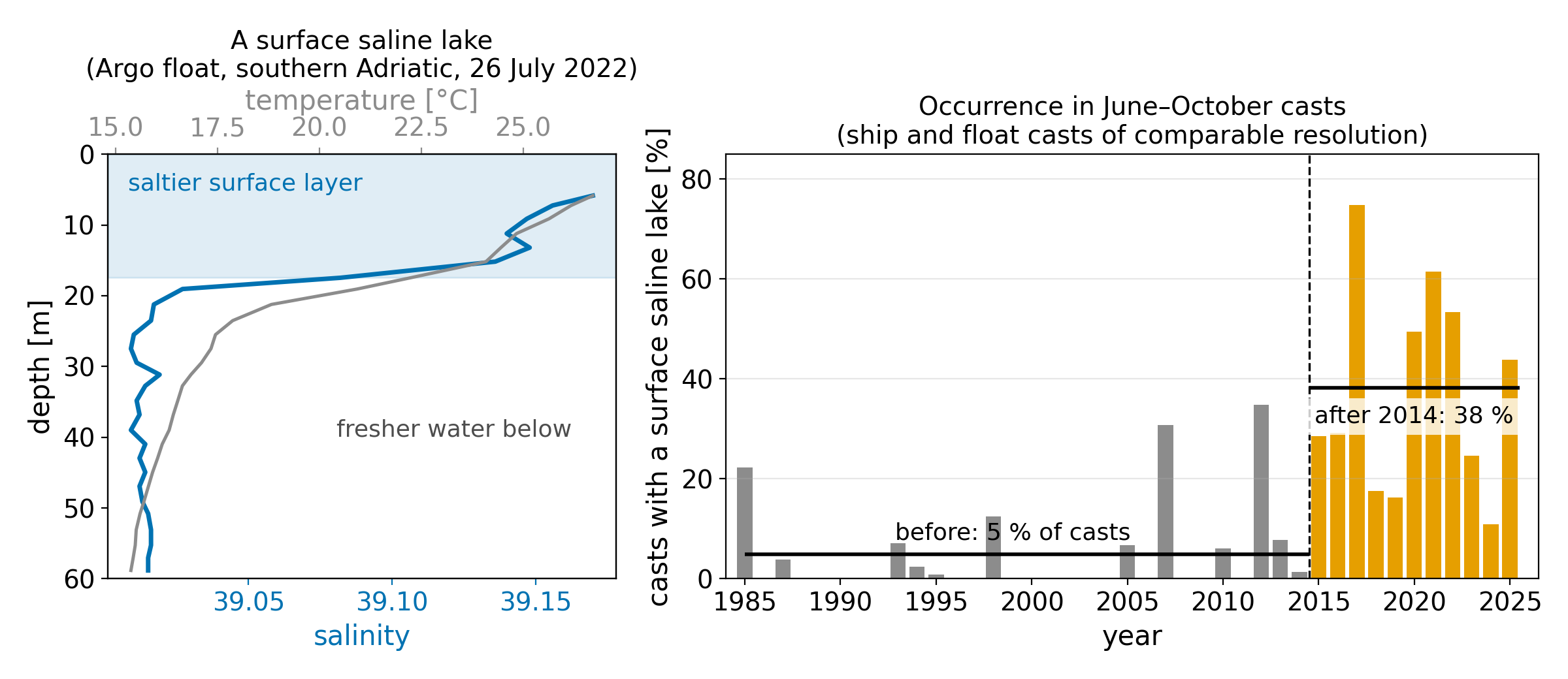
Left: an Argo float profile of 26 July 2022 with a surface saline lake, the saltier layer above 17 m. Right: share of June–October casts with a surface saline lake on ship and float casts of comparable vertical resolution, with the mean before and after 2014.
Why these changes matter
This work raises three open questions, all framed as hypotheses. First, the oxygen supply to the deep layer may be reduced, because the water that now sinks owing to its higher salinity is warmer and holds less oxygen. Second, surface saline lakes may alter the exchange of oxygen and nutrients between the surface and intermediate layers. If the salty surface layer stays stable, it seals the surface off from the water below; if the salt-driven mixing described above prevails, it carries salt, and with it oxygen and nutrients, down to intermediate depths. Which of the two dominates is not yet known. Third, ecosystems may face further challenges given the deep layer warming and salinification, which, as other studies project, might present difficulties to find cold water refugia in a semi-enclosed and rapidly changing basin.
Further investigations are needed to confirm or refute these hypotheses, by sustaining observations at fine vertical resolution, as well as with models that would simulate the episodic deep renewal.
References
, & (2026). Observational evidence for accelerated warming and salinification propagating into the deep Mediterranean. Geophysical Research Letters, 53, e2026GL124518. https://doi.org/10.1029/2026GL124518
Terzić, E., Cardin, V., Le Meur, J., Dunić, N., Vodopivec, M. and Vilibić, I. (2025a), Unprecedented warming and salinization observed in the deep Adriatic. Limnol. Oceanogr. Lett, 10: 888-898. https://doi.org/10.1002/lol2.70051
Le Meur J, Wirth A, Paladini de Mendoza F, Miserocchi S and Cardin V (2025) Intermittent supply of dense water to the deep South Adriatic Pit: an observational study. Front. Mar. Sci. 12:1516780. doi: 10.3389/fmars.2025.1516780
Amorim, F. L. L., Le Meur, J., Wirth, A., and Cardin, V. (2024) Tipping of the double-diffusive regime in the southern Adriatic Pit in 2017 in connection with record high-salinity values, Ocean Sci., 20, 463–474, https://doi.org/10.5194/os-20-463-2024
Terzić, E., Gardiol, C., and Vilibić, I. (2025b) Surface saline lakes in the Mediterranean Sea, Ocean Sci., 21, 1441–1459, https://doi.org/10.5194/os-21-1441-2025
Manca, B., Burca, M., Giorgetti, A., Coatanoan, C., Garcia, M.-J., & Iona, A. (2004). Physical and biochemical averaged vertical profiles in the Mediterranean regions: An important tool to trace the climatology of water masses and to validate incoming data from operational oceanography. Journal of Marine Systems, 48(1–4), 83–116. https://doi.org/10.1016/j.jmarsys.2003.11.025