Posted in: Ocean Sciences | Reviews & Perspectives | Ocean Science Jubilee Special Issue
We usually think of ocean salinity as the ocean’s rain gauge. Rain, rivers, and melting ice freshen the surface; evaporation leaves it saltier. Seen from space, these changing patterns reveal how Earth’s water cycle is evolving, with wet regions generally becoming fresher and dry regions saltier as the climate warms.
That familiar climate fingerprint has become increasingly clear. More than fifteen years of satellite observations, together with the global Argo float network, have transformed salinity into one of our best indicators of how Earth’s water cycle is changing. Over the past half century, long-term salinity trends have come to mirror the pattern of evaporation minus precipitation, a signature clear enough to track the water cycle’s response to warming.
But salinity is not only a record of climate change. Carried by currents, it traces where water has traveled; and at the finest scales, it can actively shape how the ocean moves and mixes. The sea surface is crossed by invisible boundaries: fronts, lenses, and filaments where waters with different histories lie side by side. Across them, temperature and salinity can change sharply over only a few kilometers, even when density looks smooth.
This shifting role motivated our new review paper, Ocean Salinity Across Space-Time Scales: From Water Cycle Indicator to Dynamical Driver. It asks a deceptively simple question: when is salinity a passive recorder of climate forcing, when does it merely trace the ocean’s movements, and when does it begin driving the ocean’s own dynamics. When, in other words, does the rain gauge begin to steer the sea (Figure 1)?
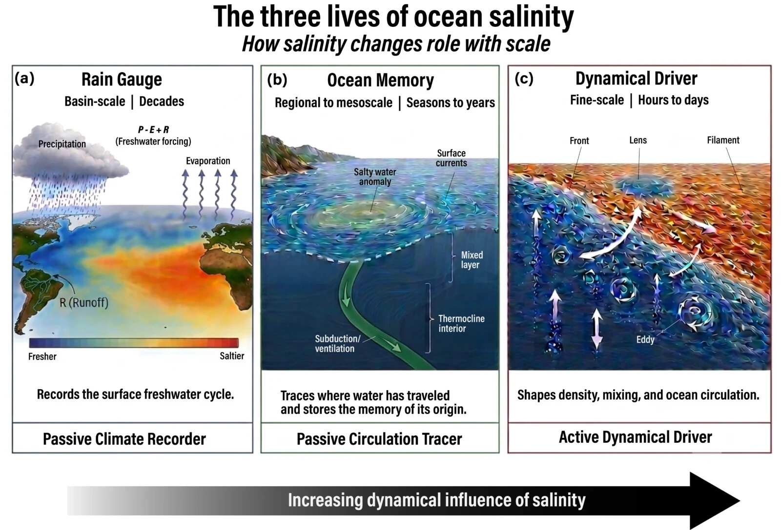
Figure 1. The three lives of ocean salinity. As spatial and temporal scale change, salinity shifts from a passive climate recorder, to a passive circulation tracer, to an active dynamical driver. At basin scales over decades, it records the surface freshwater cycle (the “rain gauge”). At regional to mesoscale ranges over seasons to years, it traces where water has traveled and stores the memory of its origin. At fine scales over hours to days, it actively shapes density, mixing, and ocean circulation. Its dynamical influence grows from left to right, though the scales are indicative rather than sharp boundaries. Adapted from the framework of Yu (2026). Image created with the assistance of Gemini 3.
What satellites made visible
Before satellites and the Argo float network, ocean salinity was poorly observed. It was sampled along shipping routes and at scattered points: sparse, uneven, and biased toward the northern hemisphere.
That changed over the past decade and a half. Three satellite missions (ESA’s SMOS, NASA/CONAE’s Aquarius, and NASA’s SMAP) gave us the first sustained global measurements of sea-surface salinity from orbit, while roughly 4,000 Argo floats added the subsurface dimension.
These observations revealed patterns that had never been seen globally before: freshwater spreading across the tropical Pacific during La Niña years, the salty subtropical gyres growing saltier, and giant river plumes from the Amazon and Congo extending hundreds of kilometers offshore. The large-scale view was transformative. But the richer it looked, the more pressing the question became: what was happening at the scales we still could not see?
The same salt, different physics
The answer depends on scale. The same salinity measurement can mean very different things depending on whether you look across an entire ocean basin or across a front only a few kilometers wide.
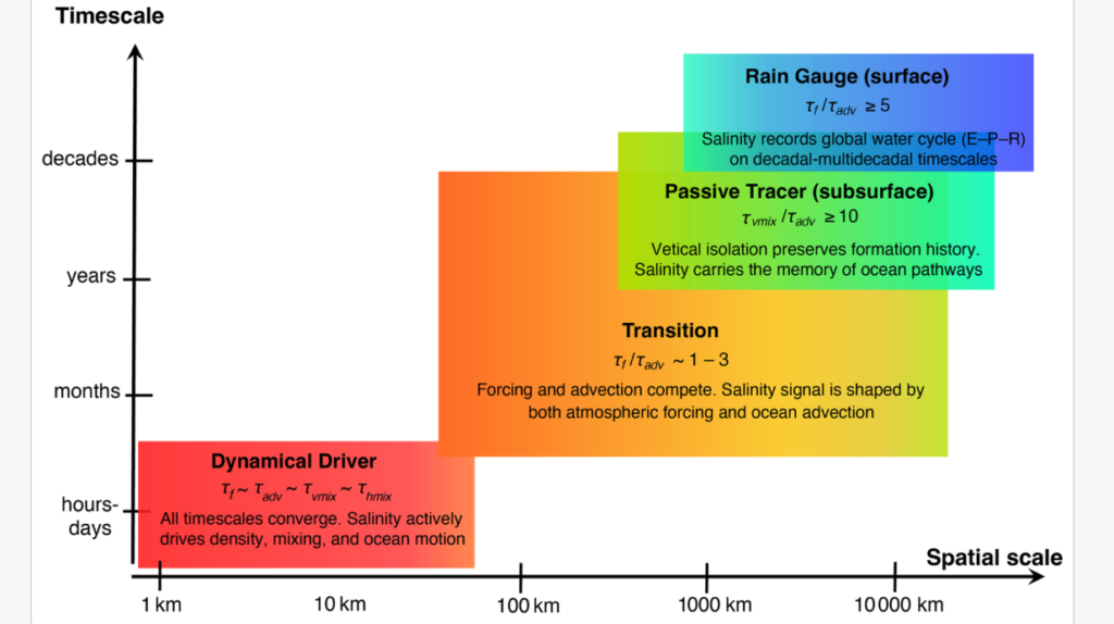
At basin scales, beyond roughly 1,000 kilometers and over decades, salinity slowly integrates surface forcing. Salty subtropical regions grow saltier, fresh tropical and high-latitude regions grow fresher, and salinity acts as a climate recorder. In some places the atmosphere writes almost undisturbed: in the Mediterranean, where evaporation greatly exceeds rainfall, salinity follows atmospheric freshwater forcing remarkably closely.
But that clean correspondence is the exception. At seasonal timescales, local freshwater forcing sets the pace of salinity change over only about one-third of the ocean (Figure 2). Across the other two-thirds, currents and mixing rearrange salinity faster than the atmosphere can imprint it.
At regional to mesoscale ranges and over seasons to years, transport takes over, and surface water carries its salinity signature into the interior as a memory of where it formed. At scales around 10 kilometers and smaller, over hours to days, salinity gradients can sharpen faster than turbulence erodes them. Here salinity no longer records or traces motion. It can drive it.
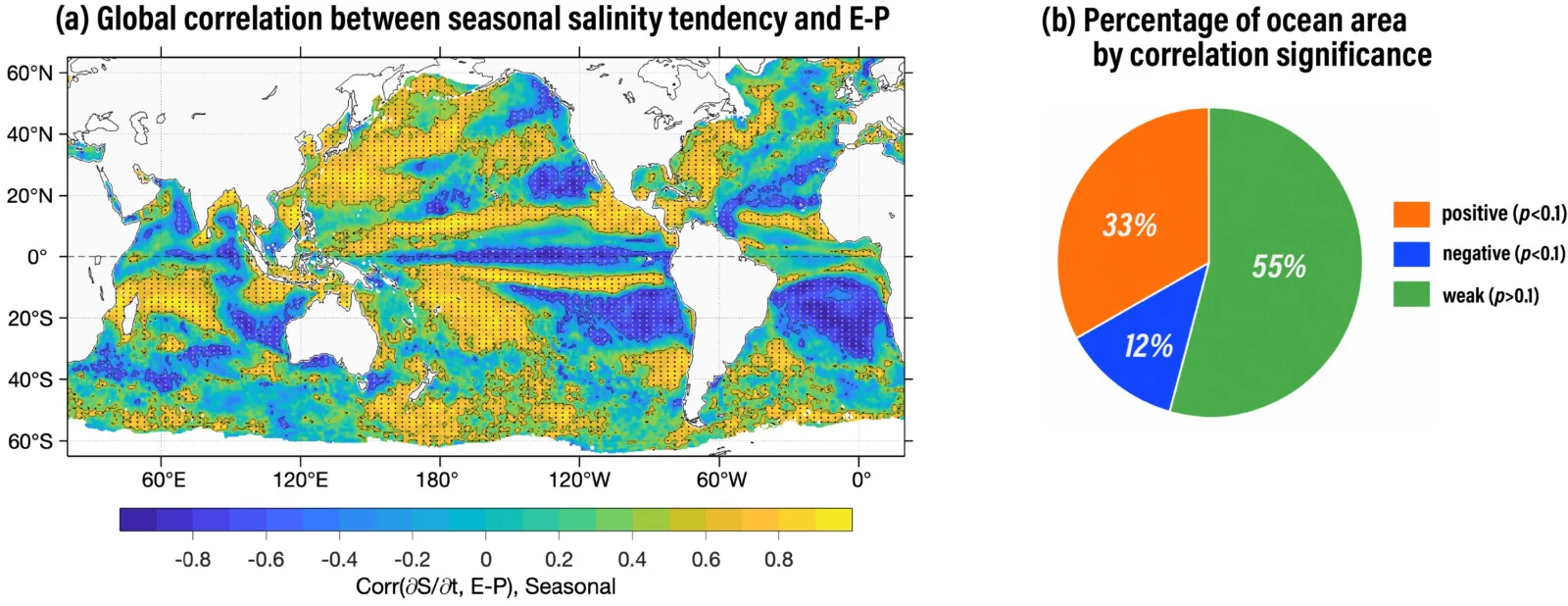
Figure 2. Where the rain gauge works. (a) Correlation between the seasonal rate of sea-surface salinity change and local freshwater forcing (evaporation-minus-precipitation, E − P); orange marks where salinity tracks the atmosphere, blue where it runs opposite, green where the two are weakly related (stippling: significant at p < 0.1). (b) Local forcing dominates only about one-third of the ocean (orange); across the other two-thirds, circulation and mixing outpace the local atmospheric imprint. Adapted from Yu (2026).
Where salt starts to steer
The reason lies in one of oceanography’s most elegant balancing acts. Warm salty water and cool fresh water can have almost the same density, even though their temperature and salinity are very different.
The salt matters more than it seems. A salinity difference of just 0.5 can change density about as much as a 2 °C temperature difference. Such fronts look weak in the density field but are not passive: they govern frontal instability, redistribute buoyancy, and control the vertical mixing through which surface climate signals enter the ocean interior.
Ironically, this is also the scale our observing system struggles to see. Today’s satellite salinity missions resolve features roughly 40 kilometers across, excellent for basin-scale patterns but too coarse to capture many of the fronts and filaments where salinity becomes dynamically important. Models, uncrewed surface vehicles (USVs), and ship surveys confirm these features exist and matter; what’s missing is a sustained global view of how they form and feed back on the larger circulation.
More than an observing gap
This is more than an observational gap. It is a gap in understanding. Climate models cannot resolve these fine-scale features directly and instead rely on simplified parameterizations of mixing. Without observations, we cannot determine whether those representations capture the right physics, and that uncertainty propagates into projections of ocean heat storage, carbon uptake, and circulation change.
One mission has already shown the scientific value of observing the ocean at finer scales. The Surface Water and Ocean Topography (SWOT) mission now maps sea surface height at resolutions approaching 10 kilometers, revealing fronts, filaments, and eddies that were previously blurred away. Yet sea surface height tells us only where the ocean is dynamically active, not why. A sharp front may be created primarily by temperature or by salinity, and those two cases evolve very differently. Temperature fronts are continually damped by air-sea heat exchange, whereas salinity fronts lack such rapid restoring and can continue sharpening, sustaining the buoyancy gradients and vertical motions that regulate mixing, heat uptake, and carbon exchange.
The missing measurement is salinity at similar scales. A next-generation sea-surface salinity mission capable of mapping the global ocean at roughly 10-kilometer resolution, alongside SWOT’s measurements of sea surface height, would reveal the density structure hidden beneath every front. The two observations would distinguish where salinity simply records atmospheric freshwater forcing from where it actively shapes ocean dynamics. That capability would not merely sharpen existing maps; it would open a new observational window on the mechanisms linking the global water cycle, ocean circulation, and climate.
Further Reading
- Reul, N., Grodsky, S. A., Arias, M., et al.: Sea surface salinity estimates from spaceborne L-band radiometers: An overview of the first decade of observation (2010–2019). Remote Sens. Environ., 242, 111769. 2020. https://doi.org/10.1016/j.rse.2020.111769.
- Vinogradova, N., Lee, T., Boutin, J., Drushka, K., Fournier, S., et al.: Satellite salinity observing system: recent discoveries and the way forward, Front. Mar. Sci., 6, 243. 2019. https://doi.org/10.3389/fmars.2019.00243.
- Yu, L.: Ocean Salinity Across Space-Time Scales: From Water Cycle Indicator to Dynamical Driver, Jubilee special issue: Reviews and Perspectives, Ocean Sci., 22, 1651–1679. 2026. https://doi.org/10.5194/os-22-1651-2026.
- NASA Salinity. https://salinity.oceansciences.org/home.htm .