
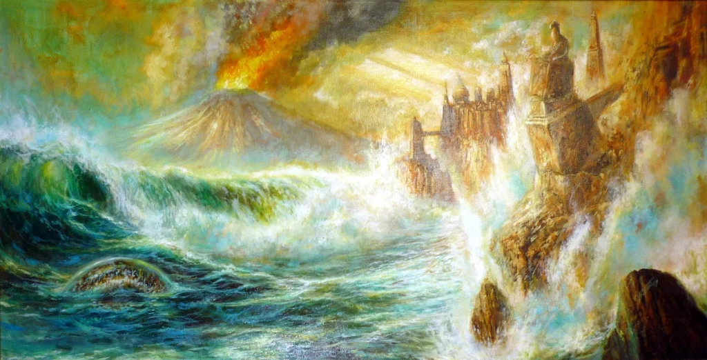
We live in a world full of mysteries and wonders… or at least that is the view of most ancient philosophers, such as perhaps Plato in ancient Greece. Atlantis, the legendary island that lay in the middle of the Atlantic Ocean, is said to have been completely destroyed overnight. To this day, numerous artists and scientists have sought to unravel the mystery of its demise, sometimes suggesting a volcanic eruption.
Today, some studies suggest an interesting connection to the island of Santorini in the Aegean Sea (Greece). But what is the scientific explanation for this connection? Was there indeed a correlation between the destruction of the mythical Atlantis and that of the Minoan civilization? Or did Plato blur the lines between fantasy and reality?
In this article, we will attempt to decipher possible clues hidden within Plato’s unique architectural description of Atlantis, which may point to the most catastrophic eruption in recent world history, the Minoan Eruption (1600 B.C.). By combining the natural volcanological explanation with the vivid ancient texts from the dialogues “Timaeus and Critias”, we aim to understand the science behind the inspiration.
Concentric Rings: A hidden geometry of a Nested Caldera
The capital of Atlantis was described as a geometric marvel built around a central hill, encircled by alternating, perfectly concentric rings of sea and land, creating an ultra-protected maritime sanctuary. Stripped of its mythological architecture, this unique layout is the classic structural blueprint of a nested caldera system. To be precise, Plato’s actual description seems to be:
“And Poseidon himself set in order with ease, as a god would, the central island, bringing up from beneath the earth two springs of waters…First of all they bridged over the circles of sea which surrounded the ancient metropolis, making thereby a road towards and from the royal palace…The greatest of the circles into which a boring was made for the sea was three stades in breadth, and the circle of land next to it was of equal breadth, and of the second pair of circles that of water was two stades in breadth and that of dry land equal again to the preceding one of water; and the circle which ran round the central island itself was of a stade’s breadth.” – Plato’s Timaeus and Critias, 360 BC (113c, 115c/e)
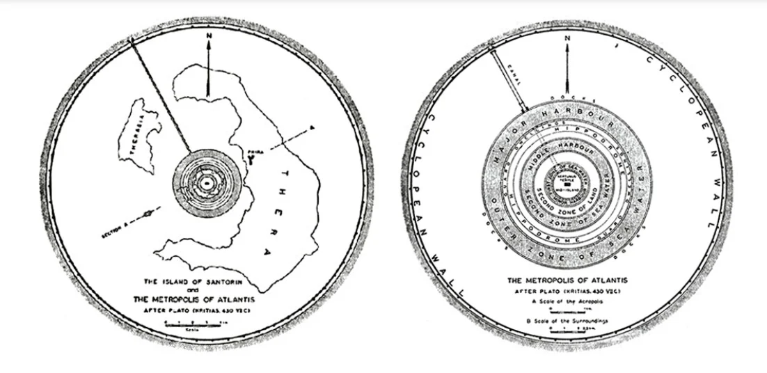
Illustrations suggesting that Santorini was in fact Atlantis, from the seminal book Atlantis: The Truth Behind the Legend by eminent seismologist Angelos G. Galanopoulos (1910-2001) and British archaeologist Edward Bacon (1906-1981).
In highly evolved, silica-rich volcanic systems, when a massive, shallow chamber rapidly empties its magma, the structural ceiling loses its upward pressure support. That is, indeed, exactly the case in Santorini’s Caldera formation. The center of the island volcano undergoes a catastrophic, vertical collapse along circular ring faults, dropping directly into the evacuated reservoir.
Thus, a wide depression gets created that is instantly breached and flooded by the surrounding ocean. Over subsequent generations, renewed volcanic activity within the flooded basin pushes new magma upward, building a new volcanic island or resurgent dome directly in the middle of the caldera. To an ancient observer standing on the surviving outer caldera walls, the resulting landscape would look exactly like a central citadel surrounded by alternating channels of land and deep sea.
Trial by Fire: The loss of an ancient world
“…and one grievous day and night befell them, when the whole body of your warriors was swallowed up by the earth, and the island of Atlantis in like manner was swallowed up by the sea and vanished;” – Plato’s Timaeus and Critias, 360 BC (25d)
And by these famous words, Plato described the end of Atlantis. A sudden, single catastrophe. While most tectonic processes operate over geological timescales, a major caldera-forming eruption is one of the few natural mechanisms capable of radically altering a regional landscape within hours or days.
But how destructive was the Minoan Eruption?
The Minoan eruption of Thera (Santorini) illustrates this rapid transformation through four distinct eruptive phases preserved in the island’s stratigraphic record:
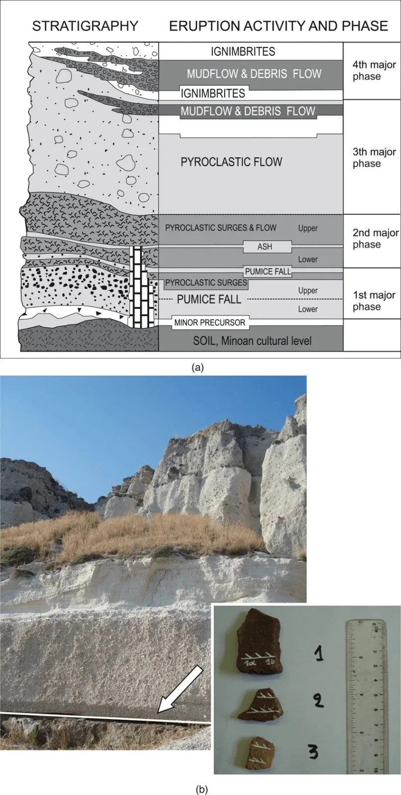
(a) Stratigraphy of the Minoan eruption deposits. (b) General view of the volcanic deposits at the Megalochori quarry. (Source: E. Tema, et al., 2015)
Pre-Minoan Soil & Precursor: A 4 cm phreatic tephra layer sits on the palaeosol, indicating an initial warning eruption.
- Phase 1 (Plinian Fall): A dry, gas-driven Plinian pumice fall blanketed the island’s ruins up to 7 meters deep.
- Phase 2 (Pyroclastic Surges): Wet phreatomagmatic surges and flows created a 12-meter stratified layer that completely buried the settlement.
- Phase 3 (Caldera Collapse): Ash and massive 2-meter lithic blocks were emplaced, signifying the structural collapse of the caldera.
- Phase 4 (Final Debris Flows): A thick sequence of ignimbrites and debris flows tens of meters deep formed the modern coastal cliffs
Examining this sequence demonstrates how a real, multi-phase eruption can destroy an island’s central structure in short order. Stratigraphy thus gives the geological footprint of a real, cataclysmic eruption that was able to alter the whole island in one night. It is, in fact, the reason that parts of Thera (Santorini) were swallowed completely by the sea.
For ancient Mediterranean societies inheriting oral histories of the event, the rapid transition from ash fall to caldera collapse provides a plausible physical origin for the inspiration of an island vanishing in “one grievous day and night”.
“Muddy Sea”: Floating Pumice and Post-Eruptive Hazards
“…wherefore also the ocean at that spot has now become impassable and unsearchable, being blocked up by the shoal mud which the island created as it settled down.” – Plato’s Timaeus and Critias, 360 BC (25d)
During explosive, high-silica marine eruptions, massive volumes of vesiculated pumice, ash, and lithic debris are ejected directly into coastal waters. Because pumice glass contains trapped micro-vesicles of gas, it remains buoyant, floating on the sea surface to form vast, compact “pumice rafts” that can persist for months and cover thousands of square kilometers.
To ancient mariners, navigating through thick rafts of floating volcanic pumice and ash would make the sea appear blocked by shallow, impassable “shallow mud”. Rather than representing a literal sinking continent, this specific detail in Plato’s text seems to work as a description of preserved historical accounts of the hazardous, debris-choked sea.
This “mud” thus, brings memories of possibly as well the image of the Aegean Sea. exactly after the Minoan Eruption.
Plato’s measurements against geodynamic reality: A striking dichotomy between spatial scales
So, what actually happens when we cross-check Plato’s description of Atlantis to reality?
At the urban scale, the central metropolis of Atlantis – approximately 27 stadia (~5 km) across – fits comfortably inside the footprint of Santorini’s 12 × 7 km caldera depression, almost mimicking the geometry of a ring-fault collapse and resurgent dome.
However, Plato’s colossal exterior plain of 3,000 × 2,000 stadia (555 × 370 km) vastly exceeds the physical limits of any terrestrial magmatic system, far outstripping even the largest known supervolcanic collapses like Toba or Yellowstone.
Seismologist Anghelos Galanopoulos, in 1969, proposed the famous “Factor of 10” hypothesis. He suggested that Solon or Plato misread Egyptian numerical symbols, translating a 300 × 200 stadia (~55 × 37 km) regional Aegean basin into empire-sized dimensions, and shifting an eruption 900 years prior into a mythical 9,000 years. By applying this single scalar correction, Plato’s grand political allegory snaps right back into direct alignment with the physical dimensions and Bronze Age timing of the Minoan catastrophe.
Geological Inspiration vs. Mythical Reality
Ultimately, physical volcanology cannot definitively prove that Santorini was Atlantis, nor was that likely Plato’s intent. Writing Timaeus and Critias in the 4th century BCE, more than a millennium after the Minoan eruption (~1600 BCE), Plato was crafting a philosophical allegory about civic virtue and hubris, not a literal historical log. The Minoan volcanic event might have served as an excellent inspiration for Atlantis.
Geomythology reminds us that human history and deep-earth processes are profoundly bound together. Long after our precise stratigraphic columns are drawn, the stories we pass down continue to echo the raw, inescapable reality of a living planet.
And who knows? Maybe, humanity didn’t lose a continent to the wrath of the gods…we just gained a spectacular, two-thousand-year-old case study in what happens when the ocean tries to drink straight from a rhyodacitic chamber.
Bibliography:
- Plato, Critias (c. 360 BCE), (https://topostext.org/work/553, https://topostext.org/work/552)
- Palaeomagnetic analysis on pottery as indicator of the pyroclastic flow deposits temperature: new data and statistical interpretation from the Minoan eruption of Santorini, Greece (E. Tema, E. Zanella, F.J. Pavon-Carrasco, D. Kondopoulou and S. Pavlides), 2015
- Atlantis: The Truth Behind the Legend. (Galanopoulos, A. G., & Bacon, E. (1969))
- Santorini Volcano. (Druitt, T. H., et al. (1999) )

Holly Stein
Hi Aretí,
Really nice article/blog. Minoan Meltdown – great title. Very well written and an exciting scientific story that reaches the audience. Hope you get good feedback!
Cheers, Holly Stein
EGU GMPV Division President
Aretì Angeli
Thank you so much for the comment!
I am so glad you liked it!
Cheers to you too,
Aretì