Part 2 – the regional case
In our previous post, we discussed global scale phenomena, showing how the Global Navigation Satellite Systems (GNSS) constellation is the ultimate instrument for monitoring the Earth as a whole: tracking plate tectonics, defining the planet’s absolute size, and measuring variations of its gravity field. Essentially, the big questions of our constantly changing planet.
Now, it’s time to take a closer look at the more local use cases. The global GNSS infrastructure provides us with millimeter-level precision for regional or local-scale applications, enabling a vital infrastructure of distributed sensors right under our feet. What does it mean in practice? It means geoscientists can observe regional phenomena — watching a volcano inflation, measuring the invisible water stored beneath the surface, water vapour content in the atmosphere, or precisely tracking the sinking of a city due to groundwater use.
In this second post, we dive into these essential regional and specialized geoscience use cases. We’ll explore how GNSS are being harnessed to manage natural hazards, monitor weather events and climate change, track the state of the atmosphere and climate impacts, and achieve breakthroughs relevant to communities around the world. The science might be global, but the impact is always local.
GNSS added value
The scientific value of GNSS data originates from three primary sources of information: geometric changes in receivers’ positions, signal transmission delays/disturbances, and reflections.
If the receiver is properly mounted on a bedrock at a ground station, geometric position changes can monitor a wide spectrum of geophysical processes. These include broad-scale crustal deformations driven by plate tectonics and or post-glacial station rebound; episodic events like earthquakes and volcanic activities; localized ground changes such as land subsidences and landslides; and loading effects from ocean tides, atmospheric pressure, and hydrology. Signal transmission delays, which arise from the propagation of L-band GNSS signals through the atmosphere, provide valuable information for monitoring ionospheric and tropospheric processes (i.e., space weather and water vapor content changes). Finally, signal reflections contain information about surface properties and environmental conditions, such as soil moisture, snow depth, and ocean roughness.
Geometric changes
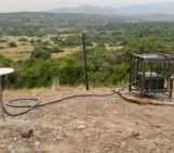
When it comes to tracking Earth’s shape, the GNSS network serves as a global system for high quality geometric observations (Figure 1). This capability is fundamental for monitoring active deformations, such as those caused by surface loading. In hydrogeodesy, GNSS excels at monitoring the elastic deformation of the Earth’s crust induced by water-driven mass redistribution. For example, when snowpack accumulates, soils become saturated, or when groundwater levels change, GNSS stations precisely measure the resulting three-dimensional crustal movements. This allows scientists to quantify changes in the total amount of water in large catchment basins (e.g. Amazon basin).
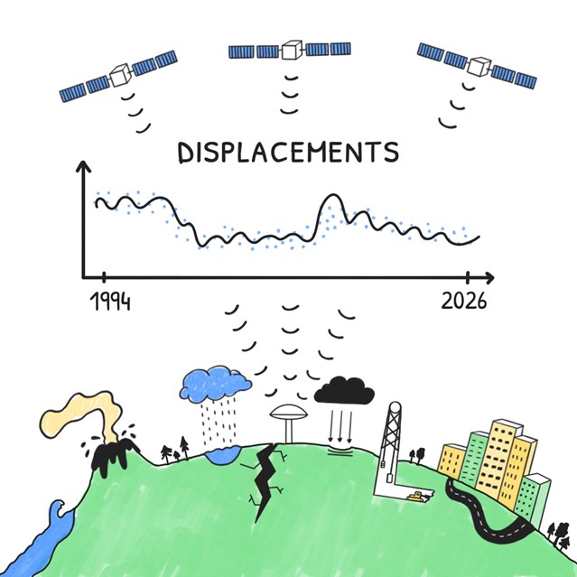
Figure 1: Tracking Crustal Displacements. GNSS continuously measures Earth’s subtle, millimeter-scale deformations caused by a wide range of processes.
However, hydrology is not the only source of deformation. A complete picture must also account for periodic loading caused by changes in the atmospheric pressure, by the enormous weight of ocean tides pushing on the seafloor, and even tiny wobbles in Earth’s rotation that disrupt the planet’s balance and cause polar tides. Last but not least, the displacements from solid Earth tides — where the solid crust itself bulges in response to the Moon and Sun — helps scientists to refine their models of the Earth’s internal structure.
Geometric position data is also essential for risk and infrastructure management. GNSS detects instantaneous displacements and tracks trends or accelerations of landslides or urban subsidences. This offers a critical warning time particularly for slow movements and provides an observational basis for managing geohazards, e.g. urban sinking caused by groundwater extraction in major metropolitan areas. Similarly, GNSS provides essential long-term monitoring of geometric changes in mining areas including post-mining deformations, tracking surface stability and managing infrastructure risks associated with subsurface voids.
In volcanology, dense GNSS networks surrounding volcanic centers also track magma chamber inflations and related ground movements with a high temporal resolution. Such continuous deformation monitoring detects pre-eruptive signals, providing critical forecasting data and saving lives in regions like Iceland, Japan, and Hawaii.
The field of GNSS seismology emerged when high-rate GNSS receivers made it possible to capture ground motions with sufficient precision and temporal resolution. The ability to gauge the true scales of ruptures timely and accurately, revolutionized tsunami early warning systems. Recently, modern processing methodologies allow GNSS to reliably detect millimeter-level displacements, even those originating from low-magnitude tremors, demonstrating their usefulness across the entire spectrum of seismic activities.
Finally, in the cryosphere, GNSS receivers placed directly on glaciers and ice sheets measure ice dynamics, providing velocity and acceleration vectors critical for estimating mass balance and modeling contributions to global sea level rise.
Signal delays and disturbances
The signal transmitted from the satellite is delayed on its path to the ground receiver, turning every GNSS ground station into a sophisticated atmospheric spy. The mechanism is straightforward: the L-band signal is delayed and slightly bent as it propagates through the ionosphere, the electrically charged layer of the atmosphere, and the troposphere, where weather phenomena occur (Figure 2).
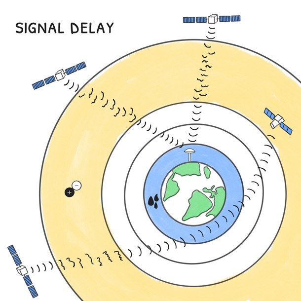
Figure 2: Signal Path Delays. Signals are delayed as they pass through the atmosphere (troposphere and ionosphere), providing data for weather and space weather monitoring.
Useful meteorological information comes from the GNSS tropospheric parameters representing a signal path delay and bending caused by atmospheric pressure, temperature and water vapor content. Since water vapor is the fuel for weather systems, tracking such delays provides continuous data with high temporal resolution that is valuable for “nowcasting” severe weather events. This lets us monitor the total moisture content swirling within atmosphere dynamics and forces like hurricanes and atmospheric rivers, supporting the quality and resilience of mesoscale or global numerical weather models, mainly to support weather short-term predictions. In addition, by monitoring disturbances and propagation delays of GNSS signals on multiple frequencies when passing through the ionosphere, we also obtain information about the Total Electron Content (TEC) and its fast temporal changes (e.g. scintillations, geomagnetic storms). Consider this our early warning system, offering crucial insights on space weather needed to safeguard critical infrastructure against impacts of severe solar radiation events.
But why limit the surveillance to the Earth surface? Many Low-Earth-Orbit (LEO) satellites carry specific GNSS receivers, which can be used for tracking of GNSS signals occulted by the Earth’s body. The so-called Radio Occultation (GNSS-RO) technique is then a powerful space-based instrument for global atmospheric remote sensing. The elegant mechanism works by estimating a subtle bending angle of the GNSS signal of the occulted satellite as it passes through the atmosphere to a receiver on a LEO satellite. This process allows scientists to calculate vertical profiles of the atmospheric index of refraction, revealing precise atmospheric temperature, water vapor, and electron density. Hence, key data can be assimilated into numerical weather models to improve forecasting as well as to support global climate research.
Signal reflections
New frontiers in remote sensing harness GNSS signals that interact with the Earth system beyond a direct signal reception. The reflection dimension of GNSS data is an active area of research known as reflectometry. The GNSS Reflectometry is a versatile technique that captures signals specularly reflected off the Earth’s surface. By analyzing these reflected signals, scientists can retrieve information on surface properties such as soil moisture, snow depth, vegetation biomass, and sea surface level and roughness (Figure 3).
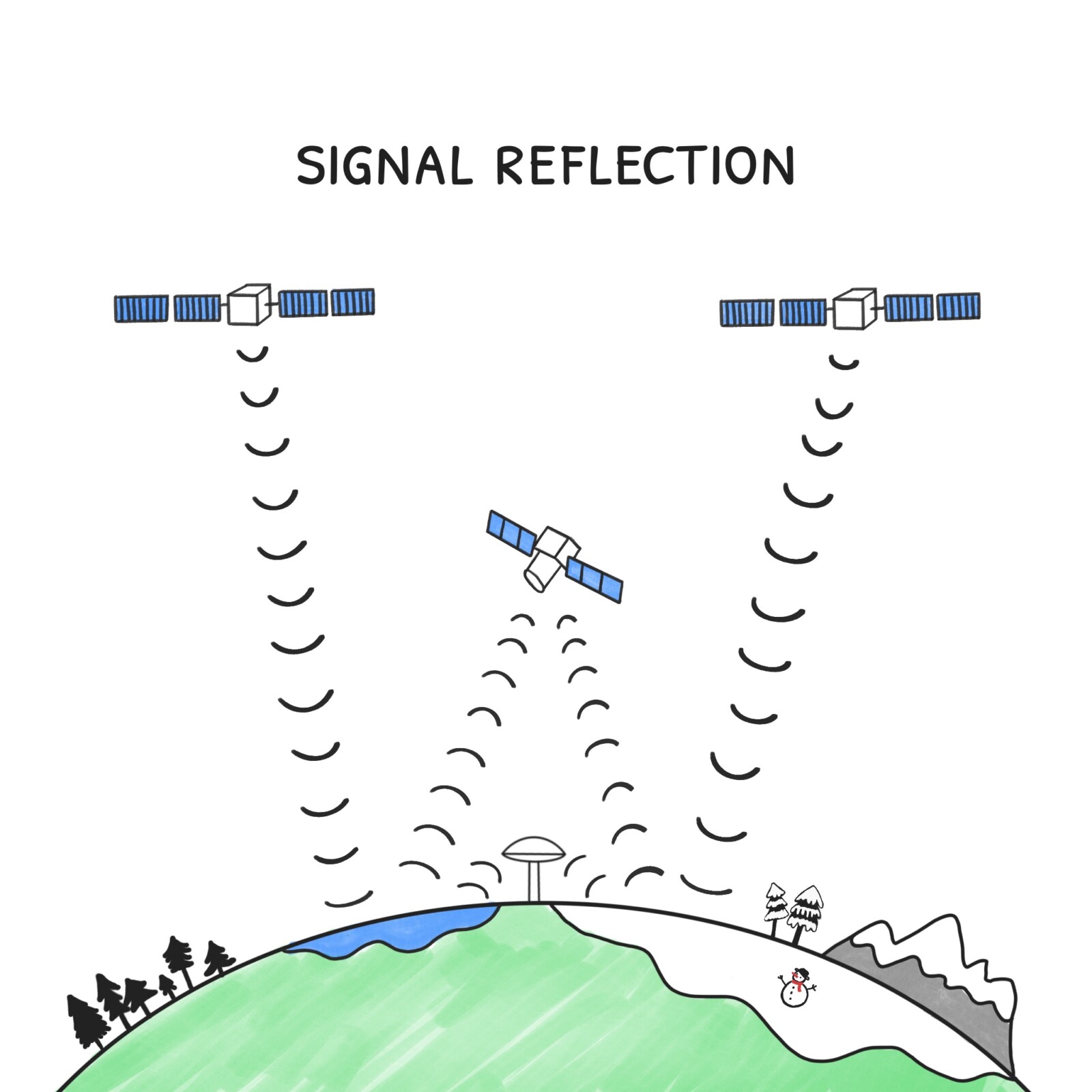
Figure 3: Signals bouncing off the Earth’s surface are collected by ground or space-based receivers. The GNSS-Reflectometry technique is used to measure critical surface properties like soil moisture, snow depth, and sea surface characteristics.
This reflection capability is generally split into two main techniques: the GNSS Interferometric Reflectometry (GNSS-IR): This method uses a single, fixed, ground-based antenna to analyze the interference between the direct signal and the signal reflected off the surface (multipath effect). The GNSS Reflectometry (GNSS-R): This employs specialized receivers and high-gain antennas, often mounted on small Low-Earth-Orbit (LEO) satellite constellations like NASA’s CYGNSS or the ESA’s HydroGNSS Scout mission. This spaceborne approach enables the global measurement of surface heights, soil moisture, and physical properties. An emerging technology in this branch is GNSS bistatic SAR (GNSS-SAR). Bistatic GNSS SAR works by using GNSS satellites as a source of radio “light”, then a special receiver on an aircraft, drone, or satellite listens for the signals after they bounce off the ground. By analyzing those echoes, it can build a picture of the surface and spot changes or objects even in darkness or bad weather.
The backbone of Earth observation
If you haven’t had enough, GNSS receivers are a core component of most modern Earth observation missions (Figure 4), serving a dual purpose. Firstly, Low Earth Orbit (LEO) satellites carry GNSS receivers that continuously track their precise position in space. This accurate positioning is essential for missions such as ESA’s Copernicus Sentinel satellites monitoring climate change, CryoSat-2 measuring polar ice variations, and EUMETSAT meteorological satellites, among many others. Without GNSS-based orbit determination, satellites could not accurately georeference their observations, rendering the billions invested in Earth observation infrastructure largely useless. One could say that GNSS is truly the cornerstone of the entire LEO satellite Earth observation ecosystem, as it underpins precise positioning of these satellites.
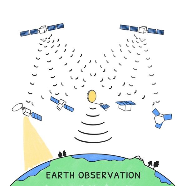
Figure 4: The GNSS role in the LEO satellite remote sensing ecosystem.
Interestingly, the orbit determination of LEO satellites itself is a valuable source of information too. Observed orbital variations allow scientists to infer the perturbing forces acting on the satellite, including those related to Earth’s gravity field.
From the ground to the outer atmosphere, GNSS quietly connects every layer of the Earth system. It is no longer just a navigation tool — it has become a global scientific tool, anchoring the measurements that reveal how our planet breathes. Whether tracking the rise of the oceans, forecasting tomorrow’s storms, or detecting the slow heartbeat of land subsidences, GNSS provides the invisible thread linking local observations to global understanding. As technology advances and data networks expand, the precision and ubiquity of GNSS promise to continue to transform geosciences — helping us not only map the Earth, but truly understand how it lives.
Further reading:
- Bock, Y., & Melgar, D. (2016). Physical applications of GPS geodesy: A review. Reports on Progress in Physics, 79(10), 106801. https://doi.org/10.1088/0034-4885/79/10/106801
- Guerova, G., Jones, J., Douša, J., Dick, G., de Haan, S., Pottiaux, E., Bock, O., Pacione, R., Elgered, G., Vedel, H., & Bender, M. (2016). Review of the state of the art and future prospects of the ground-based GNSS meteorology in Europe. Atmospheric Measurement Techniques, 9(11), 5385–5406. https://doi.org/10.5194/amt-9-5385-2016
- Schubert, G. (Ed.). (2015). Treatise on geophysics (2nd ed (Online-Ausg.)). Elsevier Science. ISBN: 978-0-444-53803-1
- White, A. M., Gardner, W. P., Borsa, A. A., Argus, D. F., & Martens, H. R. (2022). A review of GNSS/GPS in hydrogeodesy: Hydrologic loading applications and their implications for water resource research. Water Resources Research, 58(7), e2022WR032078. https://doi.org/10.1029/2022WR032078
Financing
This post is an action carried out within the project “BIG4 – Benefits of GNSS Integration for Geodesy, Geophysics and Geodynamics”, implemented by Radosław Zajdel and financed by the European Union’s Horizon Europe and the Central Bohemian Region under the Marie Skłodowska-Curie Actions — COFUND, Grant Agreement ID 101081195 (“MERIT”). Views and opinions expressed are solely those of the author and do not necessarily reflect those of the European Union or the Central Bohemian Region. Neither the European Union nor the Central Bohemian Region can be held responsible for them.
– Graphics designed by Jowita Junke
– Edited by Leire Retegui-Schiettekatte and Marius Schlaak