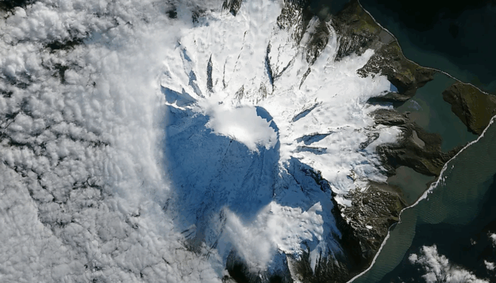
In this blog post Dr Levan Tielidze from Monash University and Securing Antarctica’s Environmental Future shares insights from a new glacier assessment of Heard Island. Although rarely visited and largely unknown, Heard Island plays an outsized role in understanding how the Southern Ocean cryosphere is responding to global warming. The island is one of the few sub-Antarctic locations with active glaciers and volcanism in close proximity, making it a natural observatory for studying climate–ice interactions under isolated conditions. Figure credit: NASA Earth Observatory.
Have you heard about Heard Island?
Heard Island lies in the southern Indian Ocean, roughly 4,100 km southwest of mainland Australia and about 1,600 km north of Antarctica. It is part of the Australian external territory of Heard Island and McDonald Islands and is one of the most remote landmasses on Earth. The island sits at approximately 53°S and 73°E, directly in the path of the powerful westerly winds known as the roaring forties and furious fifties. These winds bring frequent cloud cover, heavy precipitation, and persistently cool temperatures that have historically supported extensive glaciation.
Heard Island is dominated by Big Ben, an active volcanic massif rising to 2,813 m above sea level at the summit of Mawson Peak — the highest mountain in Australian territory. As an active volcano that height may grow and change. The island has no permanent population and no infrastructure beyond temporary field camps used during infrequent scientific expeditions. Access is only possible by ship, typically taking more than a week from Australia, and landings are often limited by harsh seas and weather.
The island’s location in the sub-Antarctic makes it a key site for monitoring environmental change in the Southern Ocean region. Its glaciers respond to both regional atmospheric warming and shifts in ocean circulation, offering valuable information for understanding cryospheric trends beyond continental Antarctica.
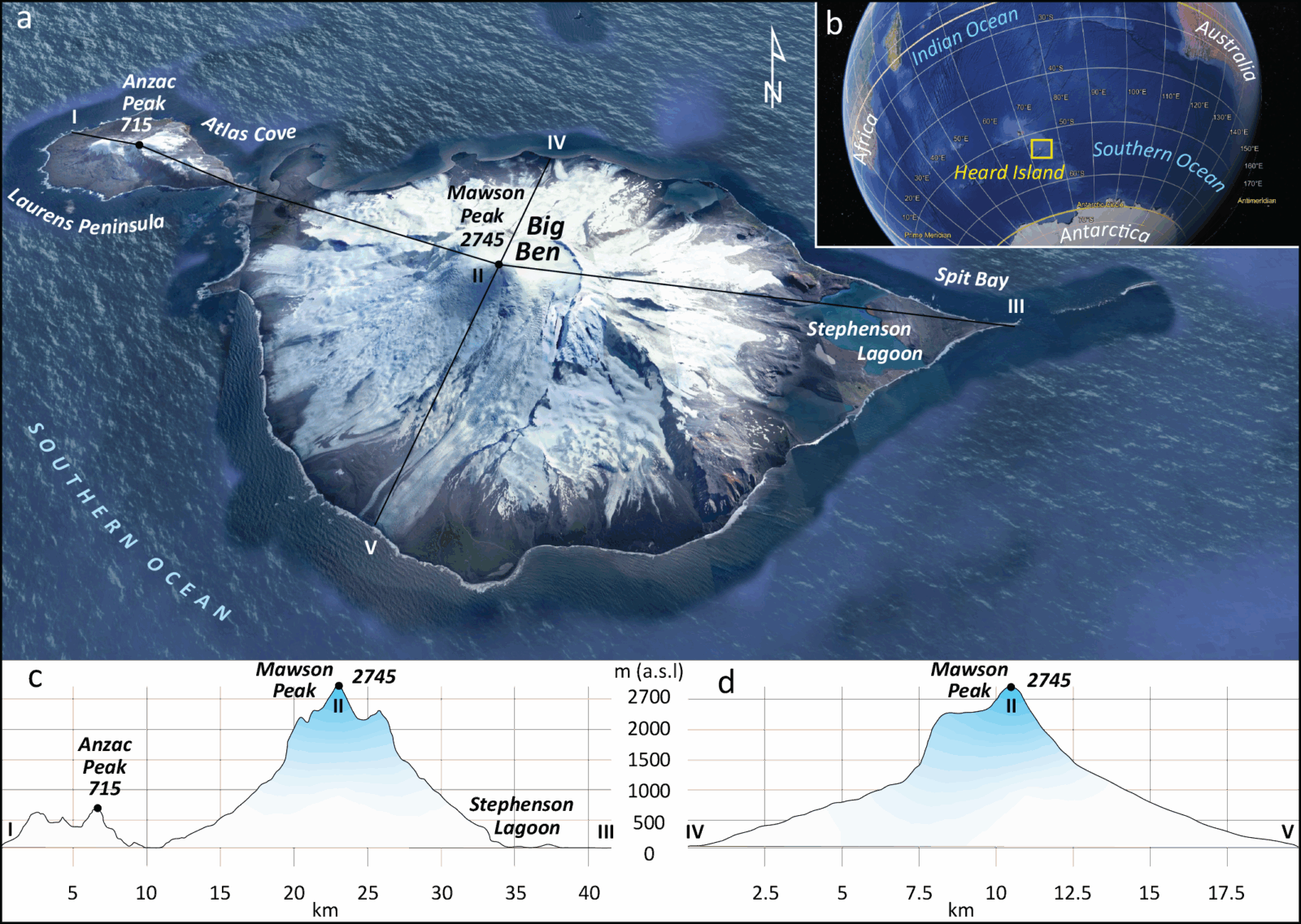
Figure 1: (a) True-colour aerial view of Heard Island. (b) Geographic position of the island in the Southern Hemisphere (© Google Earth). (c) Longitudinal and (d) transverse topographic profiles of Heard Island. Figure credit: Tielidze et al., 2025.
A new glacier assessment
A new glacier assessment for remote Heard Island in the southern Indian Ocean has revealed a sharp acceleration in ice loss over recent decades. The study which we published in The Cryosphere, provides the most complete record of glacier change on the island since the mid-20th century. Using historic maps, SPOT imagery from the 1990s and recent high-resolution Pléiades satellite data, we traced the outlines of every glacier in 1947, 1988, and 2019 to understand how this sub-Antarctic ice has responded to climate change.
Our findings are stark: total glacier area declined from around 289 km² in 1947 to 260 km² in 1988 and then fell much more rapidly to 226 km² by 2019. Although the first observation period saw an average loss rate of 0.25 % per year, the rate nearly doubled to 0.43 % per year after 1988. In total, Heard Island has lost about 22 % (63 km2) of its glacier ice area since the late 1940s. To give you a better idea, this is about the size of the Republic of San Marino.
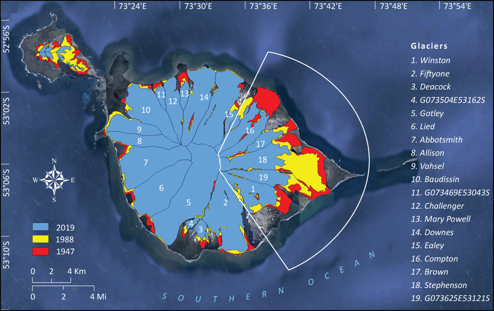
Figure 2: Heard Island glacier outlines in 1947, 1988, and 2019. The white frame highlights east-facing glaciers where the highest decrease rates occurred. Figure credit: Tielidze et al., 2025.
East-facing glaciers lead the retreat
Not all of Heard Island is responding in the same way. Glaciers flowing down the eastern and southeastern slopes are retreating fastest. These glaciers lost 22 % of their area between 1947 and 1988, and a further 30 % between 1988 and 2019. We attribute this asymmetry to orographic effects: the island’s rugged topography creates wetter, cloudier conditions on the western (windward) side, while the eastern slopes sit in drier, warmer air with less snowfall.
Stephenson Glacier on the eastern coast stands out as a dramatic example. Its terminus retreated by almost 5.8 km between 1947 and 2019—an average of over 80 m per year, rising to nearly 180 m per year in the most recent observation window. As the glacier pulled back, a large lagoon formed in its over deepened basin, further accelerating ice loss through lake calving and melt.
Figure 3. Stephenson Glacier retreat between 1947 and 2019. Figure credit: L. Tielidze.
Climate warming is a key driver
Local climate data from Heard Island are extremely scarce, so we turned to global meteorological models that cover the wider region (ERA5). We found that mean summer near-surface air temperatures increased by roughly 0.7 °C between the late 1940s and the most recent decade. Crucially, the temperature rise becomes more pronounced from the 1980s onwards mirroring the acceleration in glacier retreat.
Similar warming trends are affecting nearby Kerguelen Island, where glaciers have also been shrinking rapidly. Although volcanic activity on Heard Island can influence glaciers at short timescales, the widespread and consistent retreat across the island suggests atmospheric drivers dominate.
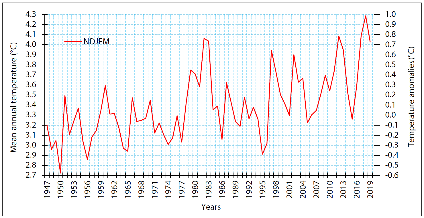
Figure 4. Mean annual warm season (November-March) temperatures and monthly air temperature anomalies (°C) for Heard Island between 1947–2019. Both values are based on the ERA5 2 m surface air temperature dataset. Figure credit: Tielidze et al., 2025.
Debris cover is rising too
An unexpected finding is the marked increase in surface debris cover. Glacier surfaces with rock or tephra cover grew from about 7 % of total glacier area in 1988 to nearly 13 % in 2019, even as the overall glacier area shrank. The maximum elevation of debris on glacier surfaces also climbed by more than 300 m over this period.
In some volcanic regions, debris cover can reduce melt where it is thick enough to insulate ice. But thin or patchy debris often enhances melt by lowering ice albedo. The new inventory does not yet resolve which effect dominates on Heard Island, but the trend suggests changing surface processes as well as retreat.
Why this assessment matters
Heard Island is a UNESCO World Heritage site with ecosystems shaped by long-term glacial isolation. As glaciers retreat, new land connections form, potentially opening pathways for invasive species and altering habitat structure. The island also serves as one of the few natural laboratories for understanding cryospheric change in the Southern Ocean, where direct observations remain sparse.
The new glacier assessment fills a key gap in global datasets. It will be made publicly accessible through the Global Land Ice Measurements from Space (GLIMS) database, supporting future modelling, conservation planning and mass balance assessments. It also allows the refinement of previous inventories such as the Randolph Glacier Inventory, where outlines on Heard Island were often missed or misaligned due to non-existence or low-resolution imagery.
Looking ahead
We emphasise that more work is needed to clarify the precise mechanisms behind the asymmetric retreat and the role of lake formation, debris cover and local climate gradients. There are also opportunities to link these physical changes to ecological impacts and to explore potential feedbacks involving volcanism and ice loss.
Still, the message from this new inventory is clear: glaciers on Heard Island are shrinking, and the pace of change has quickened considerably in the past three decades. For a remote island with limited direct monitoring, this study offers a rare and important benchmark for tracking how the cryosphere is responding to a warming world.
Edited by Emma Pearce
Further Reading:
To know more about our research please visit
https://www.monash.edu/science/schools/earth-atmosphere-environment