Measuring ice surface elevation changes with satellite laser altimeters flying hundreds of kilometres above Earth tells us where the Antarctic and Greenland ice sheets are thinning or thickening and how much they contribute to sea level rise. Beyond that though, it can also reveal hidden activity of subglacial lakes filling and draining beneath the ice and meltwater rivers flowing out towards the coast! Read further to find out how this method has been used to detect previously unknown subglacial lakes beneath slow-flowing ice close to the Antarctic coast.
Subglacial Hydrology 101
Much to some people’s surprise, water flows beneath the Antarctic Ice Sheet. But how does water get there – isn’t the ice sheet hundreds of metres thick at its edges and several kilometres thick in the middle? Well, yes, but water can still exist beneath it! Unlike in Greenland where surface meltwater can drain through crevasses, there is almost no surface meltwater reaching the ice sheet bed through crevasses and moulins in Antarctica. But, water can still be produced at the base of the ice sheet from pressure melting of the overlying ice, geothermal heat from the ground and frictional heat produced from fast ice flow.
Beneath the ice sheet, water flows following the hydraulic potential gradient, which is controlled by the underlying bedrock slope and the thickness of the overlying ice. The thicker the ice, the more pressure the meltwater beneath it is under. This means that locally it is possible for water to actually defy gravity and flow along slope following a pressure gradient, even uphill! At large regional scales though, water still flows downhill towards the ice sheet edges, where the ice thickness is just a few hundred metres or less. This subglacial water can erode upward into the ice above it, melting it to form cavities or large efficient channels which can be linked as a network, forming a complex drainage system (read more here about how this can impact the motion of the overlying ice!).
Subglacial drainage systems also evolve according to the bedrock topography beneath the ice sheet. The rough bedrock topography beneath the Antarctic Ice Sheet means that water is able to collect in topographic depressions forming subglacial lakes beneath the ice. As a subglacial lake fills up with water, this causes the overlying ice surface to bulge, which can be detected by satellite altimeters. Likewise, lake draining is detectable as a local depression in the ice surface. These lakes can be tens of kilometres in size and several kilometres deep. Scientists call these ‘active’ lakes, because they undergo cycles of filling and draining.
Altimetry – what’s that and what’s it got to do with lakes?
To map the subglacial lakes and the movement of water, we use laser altimetry, a method that uses laser pulses emitted from the satellite. When measuring the time these pulses take after reflecting from the Earth’s surface, we can calculate the distance from the surface (read more about how it works here). By knowing the location and direction of the satellite instrument, it can determine the exact geographic coordinates of the measured point. There have been several satellite laser altimetry missions over the years including NASA’s ICESat-2 (launched in 2018). The ICESat-2 satellite has a laser altimeter which takes measurements of the Earth’s surface along repeat tracks every 91 metres. These instruments collect data at the same point in space every month and allow us to build time series of surface elevation change.
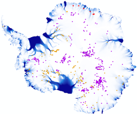
Altogether, over 140 active subglacial lakes have been recorded so far beneath Antarctica over the past two decades (Figure 1). Historically, these lakes are typically found at least 100 kilometres in land from the coast beneath fast-flowing ice streams and can fill or drain on annual to decadal timescales. Ice flow accelerations over one-two years have been linked to lake drainage events beneath several Antarctic glaciers and ice streams. Recently, it was discovered that these lakes are connected to each other and can drain in cascading networks downstream towards the coast. But there are still large regions of the ice sheet where we know very little about the subglacial hydrology beneath the ice.

Figure 2: Locations of the seven new active subglacial lakes (yellow crosses). Predicted subglacial streams (blue shading) are based on water routing analysis. Active subglacial lakes around the rest of Antarctica are shown in the inset map in orange, and stable lakes are shown as purple dots (Livingstone et al., 2022). Figure credit: Jenny Arthur.
New active subglacial lakes
In our new study, we aim to learn more about the subglacial hydrology beneath the ice sheet in the Dronning Maud Land region of East Antarctica. Very few active subglacial lakes have been recorded beneath the East Antarctic Ice Sheet, and a clear picture of the subglacial hydrology is especially lacking around its coastal regions. We especially want to improve our understanding of where subglacial meltwater is accumulating as lakes and draining towards the ice-sheet edges, and over what timescales this happens. To do this, we analyse ice surface elevation changes from the ICESat-2 satellite and its predecessor, ICESat (active from 2003 to 2008).
In this coastal region, we found seven new active subglacial lakes (Figure 2). They are all located beneath relatively thin, slow-flowing ice and the closest is just five kilometres from the Antarctic grounding line (where grounded ice meets the ocean and starts to float). This is an interesting finding, because up until now only a few subglacial lakes have been recorded beneath slow-flowing ice. Furthermore, it means that thicker, fast-flowing ice further inland is not a pre-requisite for active subglacial lake existence in this part of East Antarctica. Let’s take a closer look at one of these subglacial lakes..

Figure 3: Example subglacial lake detectable from localised ice surface elevation uplift observed in the two intersecting ICESat-2 satellite tracks and by subtracting two elevation maps from different dates in time. Figure credit: Jenny Arthur.
One of the largest new lakes we found is approximately 40 km2 and filled over around 3.5 years (Figure 3). We were able to detect this lake by recording continuous uplift of the ice surface from 2019 to 2023. Going back further in time, we found that ice over the lake had been locally subsiding from 2003 to 2009, indicating that this lake periodically drains and refills. This dynamic behaviour suggests complex interactions with the surrounding hydrological network. The locations of these new lakes also largely agree with where we predict subglacial streams to be located beneath the ice, which suggests meltwater from these lakes is moving through a system of channels into ice-shelf cavities (where the ocean reaches beneath the ice shelf).
Why are these new findings important? Well, increasing the number of observations of known active subglacial lakes will help scientists to compare lake locations and estimates of their meltwater volumes with model predictions. This will help them to better simulate the complex hydrological conditions beneath the Antarctic ice sheet. It will also help scientists to better understand the impact of water beneath the ice sheet in the coastal regions where grounded ice starts to float.
So, what do we still need to find out?
Satellite altimetry and other methods like ground-penetrating radar are now well-established methods that have been successfully used to map and track active subglacial lake activity beneath both Antarctica and Greenland. But there are still important unanswered science questions!
One of our current challenges is trying to better understand what triggers subglacial lakes to drain, as well as how they fill and drain on short (daily) timescales. We already know that in some parts of Antarctica, lakes can follow a cascade-like filling and draining pattern downstream, but this is not well understood at the scale of the whole ice sheet. We can understand lake interactions better around the whole ice sheet by using techniques like Differential Interferometric Synthetic Aperture Radar (DInSAR – phew!) to track the evolution of subglacial meltwater on daily-weekly timescales as it drains towards the ice-sheet edge.
Field measurements from radar can also show us where there are subglacial lakes and subglacial channels, especially near ice-shelf grounding lines. This can help identify subglacial outlets where meltwater is draining directly into ice-shelf cavities. However, where exactly these outlets are located, how much meltwater they release into these cavities and the influence this has on basal melting and circulation beneath ice shelves are still huge unknowns that are not yet accounted for in ice sheet models. To address these unknowns, international initiatives like RINGS are helping to collect new bed topography data around the Antarctic coast and improve our understanding of subglacial hydrology as well as ice discharge from the ice sheet into the ocean.
Further reading
There’s lots of reading out there on active subglacial lakes, but here are some suggested articles:
Arthur et al. (2024) Subglacial lake activity beneath the East Antarctic Ice Sheet in coastal Dronning Maud Land from ICESat-2 laser altimetry. The final typeset publication will be out in January 2025!
Livingstone et al. (2019) Antarctic-wide inventory of subglacial lakes.
Neckel et al. (2021) Evidence of Cascading Subglacial Water Flow at Jutulstraumen Glacier (Antarctica) Derived From Sentinel‐1 and ICESat‐2 Measurements.
Siegfried and Fricker (2021) Illuminating active subglacial lake processes with ICESat‐2 laser altimetry.
Sørensen et al. (2024) Improved monitoring of subglacial lake activity in Greenland.
Edited by Leah Muhle & Maria Scheel


SIVARANJANI S
It was really a great work Mam. Thanks a lot for the update to the cryosphere research community.