In this week’s blog post, Dr. Remya S N and Dr. Vishnu Nandan talk about how optical and radar satellite images were used to characterize the very recent catastrophic Glacial Lake Outburst Flood (GLOF) from the South Lhonak Lake in the Indian Himalaya before and after the flooding and highlight the importance of timely observations and monitoring for people’s livelihoods.
The South Lhonak Lake GLOF
In the serene glaciated Himalayan landscapes of North Sikkim, India, a tragic event unfolded on the historically vulnerable South Lhonak Glacial Lake on 4th October 2023. A sudden cloudburst led to a catastrophic GLOF. A glacial lake outburst flood (GLOF) is a sudden, catastrophic release of a large volume of water from a glacial lake, typically triggered by the failure of a natural dam made of loose soil and debris deposited by glaciers. These floods are characterised by rapid and massive discharge of water, resulting in downstream flooding, destruction of infrastructure, and pose significant risks to communities and ecosystems. However, these natural hazards are inherently unpredictable and can also have transboundary impacts.
In North Sikkim, the glacial lake drained with flood waters gushing down the valley for 50 km, flooding the Teesta River downstream, killing 42 people, including 23 Indian Army Personnel, and left more than 70 people still missing. The flooding destroyed homes, wrecked more than 30 bridges in four districts in Sikkim and ravaged portions of Sikkim’s biggest hydropower project. Because of the severe consequences, there is an urge to critically understand the factors that led to this disastrous GLOF. Through a comprehensive satellite data analysis, this blog post shows a sequential overview of events that caused the South Lhonak GLOF, shedding insights into the causes and consequences of this disaster as seen from space.
A ‘Ticking’ Disaster Risk
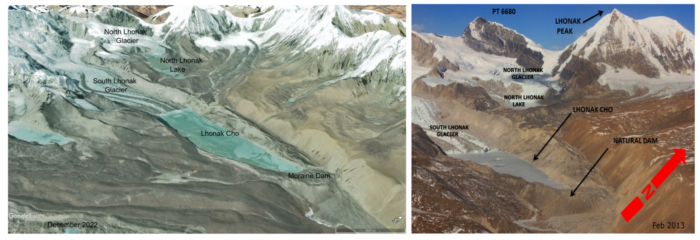
The South Lhonak GLOF resulted from a complex mix of natural forces and a series of hazards that tested the region’s resilience. The lake has been a ‘ticking bomb’ for a potential GLOF for over a decade. In a study from 2013, Raj, Remya and colleagues had raised concerns about the potential for a GLOF to take place in the valley. Their study used optical satellite data from 1962 to 2008 and showed that the South Lhonak glacier receded 1.9 km during this period. This retreat formed a moraine-dammed glacial lake at the snout of the glacier, with an estimated lake area of 98.7 hectares, 630 m wide and 20 m deep, holding a staggering 19.7 million cubic meters (or 19.7 billion liters) of water (Figure 1b). Their results showed a 42% probability for the lake to outburst and the team warned that a cloudburst forming over the moraine-dammed glacial lake could cause dangerous GLOFs.
Subsequently, in 2019, Remya and colleagues measured the lake’s depth and volume again after 6 more years. They found that its area had expanded by 0.5 square kilometres between 2001 and 2015. The volume had increased to ~ 60 million cubic meters in 2015 with a potential to increase up to 90 million cubic meters in the future when the lake completes its maximum expansion. The average depth of the lake was 51.4 meters. Their study also foresighted and recommended critical and operational monitoring of the lake as a preventive measure against future GLOFs. However, by 2023, a decade after the first report, as predicted by these two studies, the lake succumbed to a sudden cloudburst, broke its walls, leading to the catastrophic event.
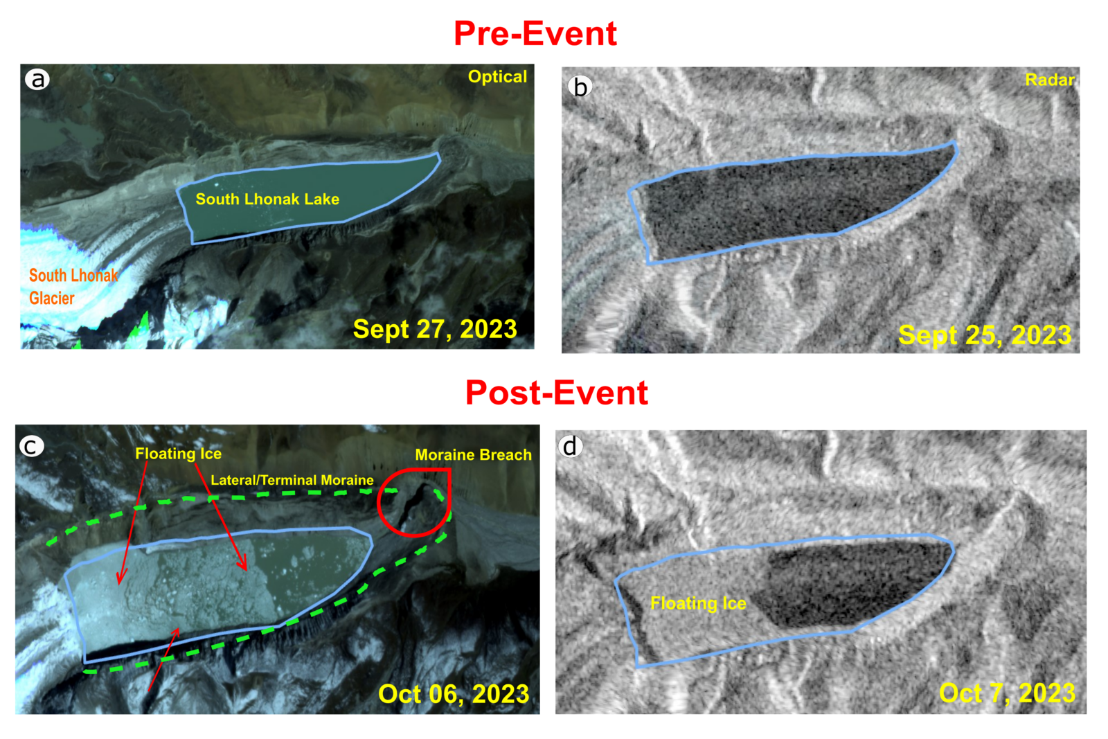
Figure 2a-b South Lhonak Lake and Glacier before the GLOF event as seen from Planet Labs optical and ESA’s Sentinel-1A radar imagery. 2c-d GLOF-affected lake with floating ice and debris as seen from satellite imagery. The approximate extent of the lake before and after the GLOF event is demarcated in blue polygon. [Radar image credit: ESA, the image contains modified Copernicus Sentinel data (2023), processed by ESA. Optical image copyright: Planet Labs (2023)].
Observing the South Lhonak GLOF from Space
Satellite imagery before, during and after GLOF has been instrumental in our analysis. Two sources of satellite images, optical and radar, before and after the GLOF event were analysed in order to understand in detail how the catastrophe happened. Planet Labs supplied 3 m high-resolution, cloud-free optical imagery, while the European Space Agency’s (ESA) Sentinel-1A radar imagery was delivered at 15 m resolution. Both radar and optical images before the GLOF event (Figure 2a-b) shows the lake expanding, covering an area of 172 hectares and volume of ~ 63 million cubic meters.
On 4th October, the sudden cloudburst triggered an ice avalanche to the lake, which led to immediate changes in the lake dynamics and volume, as clearly seen from the optical imagery acquired on 6th and radar imagery from 7th October. Figure 2c-d) shows a massive section of ice from the left (North) side had crashed into the lake. The large ice mass that plunged into the lake created high waves that overtopped the dam displacing water and transporting ice and debris towards the lake’s terminus, leading to a breach in the terminal moraine. Optical imagery showed these chunks of ice and debris floating on the lake (Figure 2c), which also potentially damaged the lateral walls of the lake. This section acted as a natural dam for the lake, causing the lake water to flow through a broader channel. The breached wall unleashed a massive surge of water and debris that rapidly cascaded downstream the valley, merging into and flooding the Teesta river and the surrounding settlements. As a result, the lake water drained via the moraine/terminal part of the lake, causing the remaining water level to drop, as observed with its smaller surface area. Figure 3 shows the schematic explaining the sequence of events that led to the GLOF.
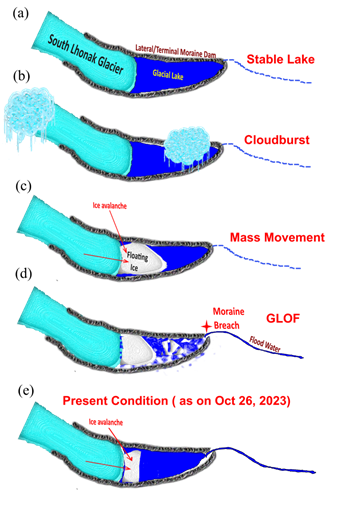
Figure 3: The schematic shows the sequence of events that led to the South Lhonak Lake GLOF, post-event and the present condition of the lake. The schematic is derived after careful examination of optical and satellite imagery used in this study and past literature [Schematic created by Remya S N]. a) South Lhonak Lake in its stable dimensions and appearance before 4th October 2023. b) Cloudburst in North Sikkim – An extreme weather event on 4th October 2023 involving a sudden cloudburst above the lake, preconditioning the GLOF. c) Glacier Ice Mass Movement – Following the cloudburst, the potential occurrence of glacier mass movement, possibly an ice avalanche, impacting the lake. d) Terminal Moraine Breach – GLOF is triggered by the failure of the terminal moraine and the subsequent release of flood water. e) Present Condition – Present status of the lake illustrating changes in surface area.
The Sentinel-1A image provides a view of the lake after the disaster, but it has a slightly lower resolution compared to the optical image from Planet Labs, making the interpretation of the lake’s condition somewhat challenging. This difference might have initially suggested that the lake had significantly shrunk. However, analysis from both radar and optical imagery between 25th September and 7th October reveals that while the water level had dropped, the surface area of the lake decreased from ~ 170 hectares on 27th September to ~ 150 hectares on 7th October. The decrease in area can be attributed from the minor breach in the terminal moraine, pushing the water to flow downstream. Such breached moraines are unpredictable in its stability, highlighting the need for continuous monitoring of the lake to prevent GLOF in future.
Is South Lhonak Lake Now Safe?
The South Lhonak region has a rather challenging terrain which restricts field monitoring. That is why using optical and radar satellite data and tools has been the only efficient and reliable way for operational and safety monitoring of this vulnerable glacial lake. We have analysed the lake’s current activity using the recent satellite imagery from 19th, 22nd (radar) and 26th October (optical). Sentinel-1A radar imagery from 19th and 22nd October (Figure 4 (a) & (b) clearly shows mass movements such as ice avalanche along the failure zone and an optical image from 26th October (Figure 4 (c)) confirms this. We anticipate that these mass movements are likely to continue frequently and over time, which would suggest that the affected region of the lake might be a potential risk in the future.
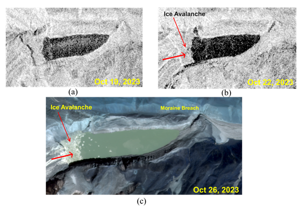
Figure 4: Present status of the South Lhonak Lake from ESA’s Sentinel-1A radar imagery from (a) 19th, (b) 22nd October 2023 and (c) Planet Labs optical imagery from 26th October 2023. Red arrows show the potential direction of ice avalanches. [Radar image credit: ESA, the image contains modified Copernicus Sentinel data (2023), processed by ESA. Optical image copyright: Planet Labs (2023).]
Effective monitoring and mitigation can reduce GLOF risks
To ensure the ongoing safety of the lake, we have been continuously using satellite imagery in collaboration with federal- and state-level disaster management agencies. These current assessments help us determine whether the lake remains stable or at risk of a further outburst. Observations shown in this blog post emphasizes the necessity of proactive measures, including systematic monitoring, early warning systems, and mitigation strategies, to safeguard downstream regions. Additionally, we suggest exploring how to use high-altitude glacial lakes as controlled meltwater storage simultaneously minimizing hazards and harnessing a valuable resource.
With rapidly retreating glaciers in the Himalayas, the importance of assessing the hazard potential of glacial lakes cannot be overstated. By combining scientific insights, informed policies, and community-driven actions, we can collectively work towards minimizing the impact of GLOFs and other climate-induced catastrophes. This comprehensive approach ensures that we are better prepared to address the challenges posed by the changing climate and safeguard the wellbeing of our communities.
Further Reading
- Published articles in 2013 and 2019 from the lead author of this blog post, warning and predicting the South Lhonak Lake GLOF
- News article in Nature India from the lead author of this blog post following the 2019 study
- Web post by the European Space Agency featuring this GLOF event
- Recent news article on the GLOF event published in DownToEarth and The Hindu
- A blogpost on Active Deformation around the South Lhonak Lake
Edited by Maria Scheel
 Remya S N is a Glaciologist and Assistant Professor at the School of Sustainable Futures, Amrita University, India. Her research focus is Himalayan Cryosphere, specialized in remote sensing and field validation of glacial lakes, glacier and permafrost dynamics. Her present research focuses on improving sustainability of downstream people in the Himalaya. Contact email: remyasn@am.amrita.edu.
 Vishnu Nandan is a sea ice researcher at the Centre for Earth Observation Science, University of Manitoba, Canada. He is a field scientist, and his research focus is Arctic and Antarctic sea ice remote sensing, specialized in using surface- to satellite-based radars towards improved retrievals of sea ice thickness and its overlying snow cover. He is also an Associate Editor of ‘The Cryosphere’ journal. Contact email: vishnu.nandan@umanitoba.ca. He tweets as @vishnu_seaice
Christopher Chambers
I have a couple of questions about this event. First there is reference to a “cloudburst” but is there actually evidence of this? Was there radar imagery, or satellite analysis to determine a cloudburst event? This article refers to another article that does not provide evidence of this.
The second is about the proposal of two simultaneous ice avalanches. It is clear that the lateral moraine collapsed into the lake triggering the lake level rise or wave but is there evidence of a 2nd avalanche coming down the glacier at the same time? If there is evidence of this I suppose it could have been triggered by the moraine collapse.