Scientists struggle to get ice samples from the depths of glaciers where fundamental pieces of information about the climate of Earth are stored. But in many places around the periphery of the Greenland Ice Sheet, you don’t need to drill a deep ice core to obtain ancient ice, you can simply walk across the ice sheet’s margin and look at the layered ice surface. There you can read the ice as though it was an open book, distinguishing the oldest pages and the new ones. Let’s see how this is possible!
Inspiration
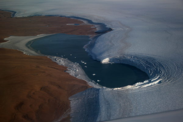
A few years ago, my colleague Mark Fahnestock sent along an image that blew me away. It was simple but effective: a Sentinel-2A satellite image draped over ArcticDEM, a digital elevation model of the Arctic. With QGIS and an eye for a straightforward argument, Mark had reproduced a classic photograph from the 1980s of the edge of the northeastern Greenland Ice Sheet. Both that photograph and Mark’s 3-D reproduction showed distinct layers emerging at the margin that are visible to the naked eye once the previous winter’s snow has melted away and exposed the underlying, much older ice.
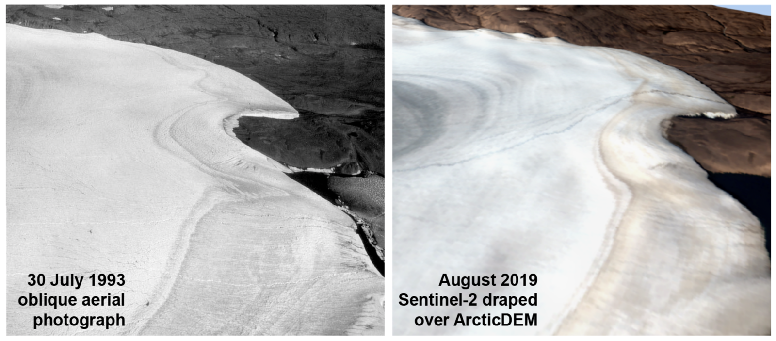
What we can see in northeastern Greenland (left), so can satellites (right). Figure credit: Reeh et al. (2002); MacGregor et al. (2020).
From the 1980s through the 2000s, Niels Reeh, a Danish glaciologist, and many colleagues studied this margin layering at two dozen sites all across Greenland. They found that changes of the isotopic composition of ice (a proxy for past temperature) between these layers were consistent with results coming from deep ice cores drilled far inland. They also found that this layering is visible because of changing amounts of mineral dust that fell on the ice surface inland more than ten thousand years ago, which was then buried and flowed hundreds of kilometers to the ice edge we see today. These patterns suggested that, in some places in Greenland, one could simply walk up to the edge of the ice sheet and coarsely date the ice by visual inspection alone, as shown in that photograph. The idea of “horizontal ice cores” was born. Instead of drilling through the center of the ice sheet, one could more cheaply sample as much ice as needed for paleoclimate studies at the margin – a not insignificant concern for many ice-core scientists who would love to have larger samples to study.
But the first explorations of Greenland’s margin layering inevitably prioritized logistical convenience, rather than the identification of the sites where the margin layering appeared to reach the farthest back in time or was easier to interpret.
In other words, no comprehensive satellite reconnaissance of Greenland’s margin existed, but once I saw Mark’s 3-D image, I knew that we could do exactly that.
Modern exploration
Our first step was to use Google Earth Engine to create a high resolution and cloud-free mosaic of whole Greenland using satellite images acquired in late summer of 2019, when the ice margin was snow-free. This mosaic allows us to examine the margin layering everywhere in its “best” condition and is also a great resource for anyone wanting to explore a snow-free Greenland remotely. Following that algorithmically elegant step was a much less glamorous one: manual tracing of the boundaries of each margin layer across all of northern Greenland. We wound up focusing on northern Greenland because ice there is generally colder, slower and older – a good combination for generating coherent margin layering.
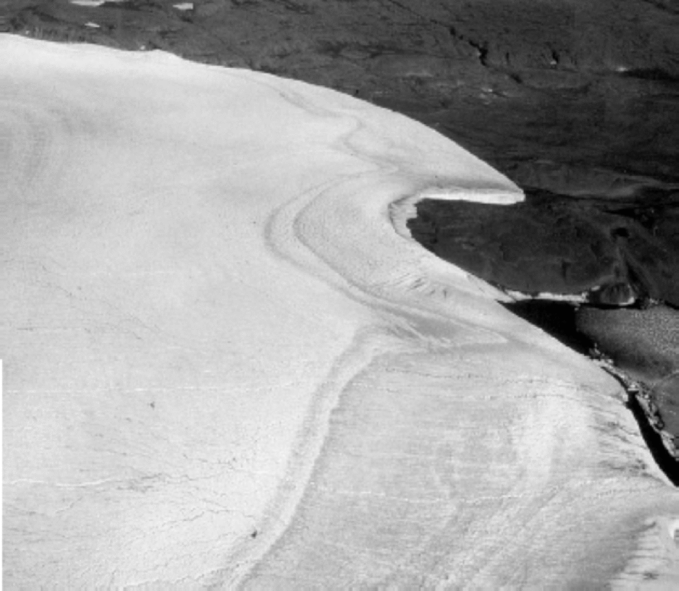
What resulted is a new perspective on the nature of thousands of kilometers of the ice margin across northern Greenland. We confirmed what the typical margin layer pattern looked like and the results matched well with Niels Reeh and colleagues’ earlier work. In addition, we could recognize where the ice was folded over on itself, where basal ice was exposed and also where the very best margin layering could be found. The oldest ice we think we can make sense of is exposed next to Warming Land, a deglaciated area in central northern Greenland. There, variations in ice brightness of the margin layering are similar to the record of dustiness from NorthGRIP, a deep ice core collected hundreds of kilometers farther south. We suspect the layers near Warming Land could stretch back 55 thousand years, well into the Last Glacial Period and including multiple Dansgaard–Oeschger events. We also collected new surface ice samples within folded layers near the enigmatic Hiawatha Glacier in northwestern Greenland and found isotopic patterns wholly consistent with earlier studies.
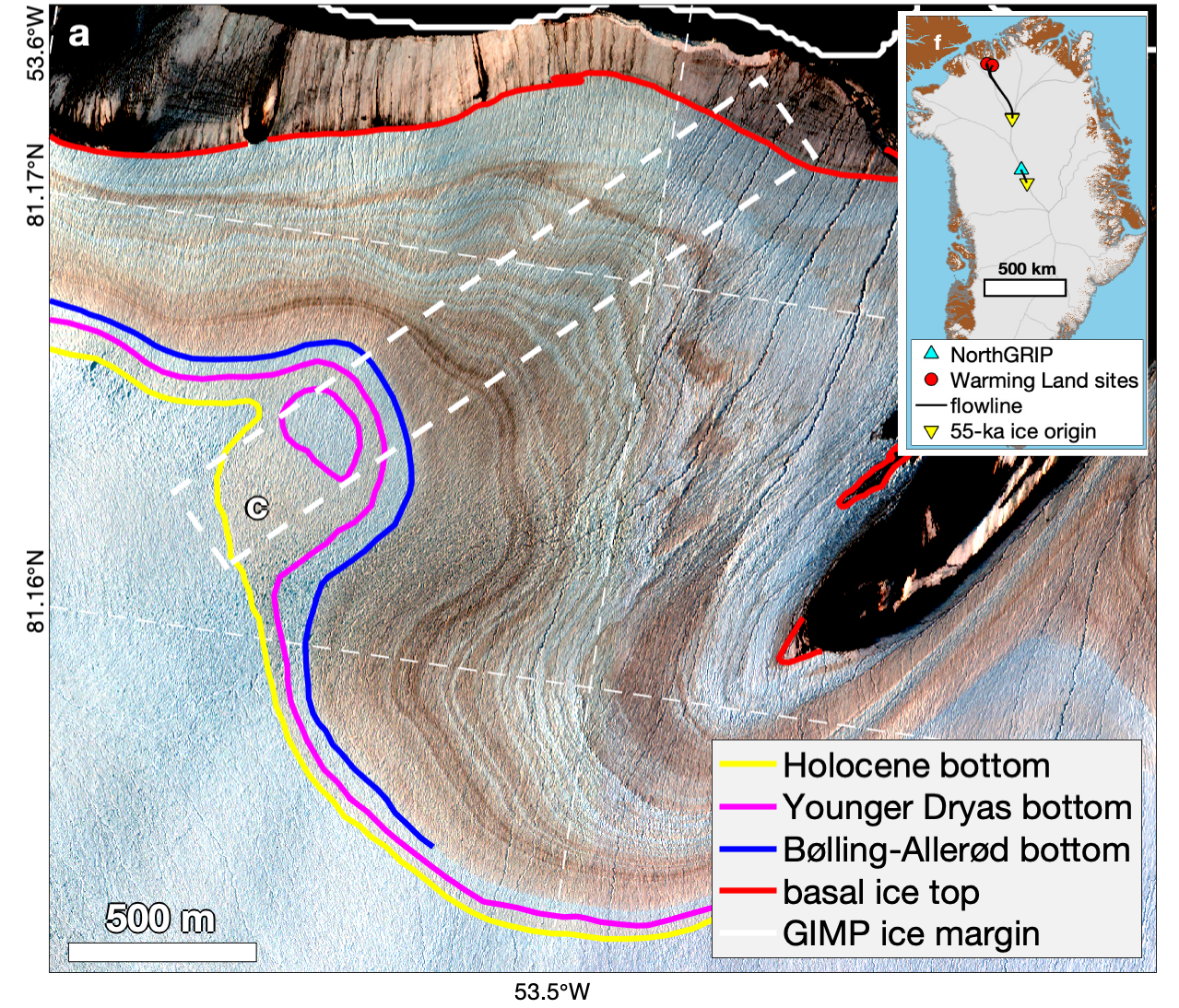
Where ice history is there for all to see near southwestern Warming Land. Figure credit: MacGregor et al. (2020).
A new foundation
Our study establishes a modern baseline for scientists seeking to unravel the history of Greenland’s ice sheet from those places where it is an open book. Northern Greenland remains hard to reach, infrequently visited and underappreciated given the ongoing dramatic changes occurring there. But for those making the journey – whether in person or using satellite remote sensing – the region offers a unique window into the past and our possible future.
Further reading:
- MacGregor, J.A., M.A. Fahnestock, W.T. Colgan, N.K. Larsen, K.K. Kjeldsen and J.M. Welker, (2020), The age of surface-exposed ice along the northern margin of the Greenland Ice Sheet, Journal of Glaciology, 66(258), 667–684, doi:10.1017/jog.2020.62.
- Reeh, N., H. Oerter and H.H. Thomsen (2002), Comparison between Greenland ice-margin and ice-core oxygen-18 records, Annals of Glaciology, 35, 136–144, doi:10.3189/172756402781817365.
Edited by Giovanni Baccolo and Marie Cavitte
 Joe MacGregor is a glaciologist at NASA’s Goddard Space Flight Center in Greenbelt, Maryland, USA. He is interested in the past, present and future of the Greenland Ice Sheet and is Project Scientist for NASA’s Operation IceBridge. He tweets as @JoeMacGregor. Email: joseph.a.macgregor@nasa.gov.