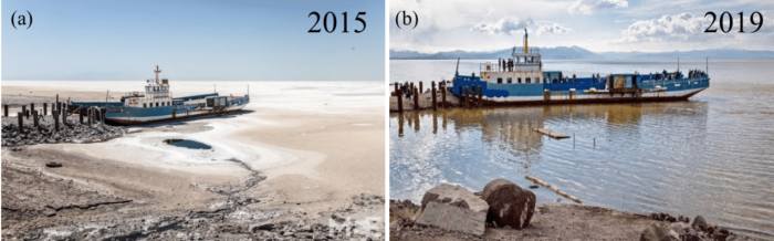
Lake Urmia, in Northwest Iran, was once the most extensive and permanent hypersaline lake (salinity >> of ocean) in the world. Since 1995, the lake water level has dropped about 8 m, shrinking to less than 30% of its original surface area and losing more than 90% of its water volume over two decades [1]. Unsustainable water management in response to increasing demand together with climatic extremes, have depleted the lake drastically (cf., Fig. 1a).
The declining water level in Lake Urmia has threatened the local population’s health and economy as well as raised national and international concerns [2]. The d(r)ying lake has also threatened the regional bio-diversity: the rare Artemia fish was endangered and Flamingo migration was heavily affected (see www.tehrantimes.com and ifpnews.com). Multiple reports from scientists alarmed the government about the grave consequences of losing this hypersaline lake, which led to establishing the Urmia Lake Restoration Program (ULRP) in 2013. Its aim was to restore the lake within 10 years in three phases, namely Stabilization (2014–2016), Restoration (2017–2022), and Final Restoration (2023) [3]. ULRP planned to increase water release from reservoirs to the lake gradually. Recently, the lake has shown some signs of revival with a gradual increase in its water level and area (Fig. 1(b) and Fig. 2). It is logical to ask if the positive changes are due to efforts from ULRP or due to natural variability. This question can be answered by monitoring changes in the lake’s health using in-situ and remote observations, such as the lake’s water level and the surface water extent from satellite optical imagery (e.g. optical images from satellite). Moreover, observations from the GRACE and GRACE-Follow On satellite missions enable us to track the total water availability in and near the lake, which when combined with precipitation and evapotranspiration data can help us understand the source of water mass change.

Figure 2: False-color satellite images of Lake Urmia for the years indicated in each panel. Data is an RGB combination of bands 2, 2, and 1 of the MODISMOD09Q1 product. This composite allows us to visualize the wavelengths that the human eye cannot see (near the infrared range). In this figure, dark blue represents deep water and light blue represents shallow water, Gray represents sand and salty land, and yellow to green represents vegetation.
The lake has been reported to show a positive trend in water level, water area, and water volume from 2015 to 2019, 14.5 cm/yr, 204 km2/yr, and 0.42 km3/yr, respectively, which indicates some recovery between 2015 and 2019 [4]. Further analysis confirms that this has been achieved mainly due to an increase in inflow from rivers and reservoirs to the lake, and due to two anomalous rainfall events in 2016 and early 2019. The stabilization appears fragile, because most of the increase in the water volume has spread over the large shallow southern region and has a high evaporation potential during hot seasons. Furthermore, there is a high correlation between the lake water level and precipitation, which suggests that the recovery observed in 2016 and the first half of 2019 are anomalies, and that under a long dry spell, the lake may become endangered again [4].
To conclude, lake Urmia, the lifeline for many in northwest Iran, is currently endangered due to human intervention (irrigation and water impoundments) and ongoing climate change. A government initiative is providing some support to the lake, but this support must be ensured over the long-term and should be informed and updated by science to make a significant difference.
REFERENCES
[1] Tourian, M. J., Elmi, O., Chen, Q., Devaraju, B., Roohi, S., & Sneeuw, N. (2015). A spaceborne multisensor approach to monitor the desiccation of Lake Urmia in Iran. Remote Sensing of Environment, 156, 349-360. doi: 10.1016/j.rse.2014.10.006
[2] AghaKouchak, A., Norouzi, H., Madani, K., Mirchi, A., Azarderakhsh, M., Nazemi, A., ... & Hasanzadeh, E. (2015). Aral Sea syndrome desiccates Lake Urmia: call for action. Journal of Great Lakes Research, 41(1), 307-311. doi: 10.1016/j.jglr.2014.12.007
[3] ULRP, 2015a. Foundation. URL. http://www.ulrp.ir/en/foundation/, Access date: 6 May 2020.
[4] Saemian, P., Elmi, O., Vishwakarma, B. D., Tourian, M. J., & Sneeuw, N. (2020). Analyzing the Lake Urmia restoration progress using ground-based and spaceborne observations. Science of The Total Environment, 139857. doi: 10.1016/j.scitotenv.2020.139857
This post has been edited by the editorial board.