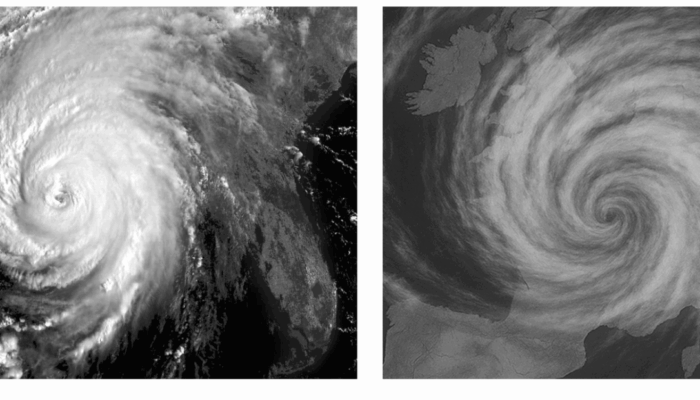
EGU Blogs

5027 search results for "6"

GD
Geodynamics

H2 production associated with mantle wedge hydration in subduction zones

H2 production associated with mantle wedge hydration in subduction zones

Dihydrogen (H2) is a promising source of energy that may allow reducing carbon emissions in industry and transportation. Artificial production methods have been explored, natural sources of H2 (also called white dihydrogen) offer a more eco-friendly and cost-effective production process. In this week’s blog post, Alexis Gauthier, a PhD student from ISTeP, France, is discussing the H2 production pr ...[Read More]

SM
Seismology

Earthquake Watch: Seismicity in the Reykjanes Peninsula, Iceland

Earthquake Watch: Seismicity in the Reykjanes Peninsula, Iceland

For this Earthquake Watch we are very happy to have Yesim Cubuk-Sabuncu write about the seismicity around the recent eruptions in the Reykjanes Peninsula, Iceland! Yesim is a postdoctoral researcher in seismology at the Icelandic Meteorological Office, Service and Research Division since 2019. She obtained her Ph.D. in Geophysical Engineering at the Istanbul Technical University, Turkey in 2016. L ...[Read More]

GeoLog

GeoPolicy: Fluvial geomorphology and its potential for policy impact

GeoPolicy: Fluvial geomorphology and its potential for policy impact

In this month’s GeoPolicy blog post, Dr Grace Skirrow outlines how researchers can share their expertise with environmental regulators to have policy impact and the role that fluvial geomorphology can play in policy decisions. Fluvial Geomorphology and why it is relevant for policymakers Fluvial Geomorphology (“fluvial”, derived from the Latin “fluvialis”, meaning “of the river”) is the study of l ...[Read More]

G
Geodesy

High resolution terrestrial water storage changes from combination of GRACE and models

High resolution terrestrial water storage changes from combination of GRACE and models

The Gravity Recovery and Climate Experiment (GRACE) satellite mission (2002-2017) consisted of two satellites at ~500 km altitude separated by 200 km, following each other in the same orbit. The distance between the two GRACE satellites changes because of the gravitational pull of the masses beneath the satellites. As such, mass changes at or near the Earth’s surface caused variations in the dista ...[Read More]

GD
Geodynamics

Animating the past using numerical modeling

Animating the past using numerical modeling

The human lifespan is too short compared to the geological time. To comprehend long-term phenomena, numerical modeling emerges as an imperative approach. But, there are several ways for visualizing the output of these models. Among these, animations stand out as a powerful tool, allowing us to watch the dynamic evolution of our planet over geological epochs like a movie. Our lives are too short co ...[Read More]

HS
Hydrological Sciences

Meet the Hydrological Sciences (HS) Early Career Scientist (ECS) Team

Meet the Hydrological Sciences (HS) Early Career Scientist (ECS) Team

Who Are We? At the forefront of hydrology’s fascinating world, there is a dynamic group of young scientists passionate about understanding the complexities of water in all its forms: The HS Early Career Scientists (ECS) from the European Geosciences Union (EGU).  The HS ECS team is a heterogeneous, multidisicplinary and devoted group of passionate individuals from diverse geographical locations wo ...[Read More]

SM
Seismology

Seismology Job Portal

Seismology Job Portal

On this page, we regularly update open positions in Seismology for early career scientists. Do you have a job on offer? Contact us at ecs-sm@egu.eu Please, note that other available research positions are displayed on the EGU Jobs Portal.   Latest open positions: Postdoctoral Fellow (Earthquake Hazards) Institute: The University of Texas Institute for Geophysics (UTIG) Starting: January 2024 ...[Read More]

NH
Natural Hazards

New Era of AI: How can foundation models help disaster risk reduction?

New Era of AI: How can foundation models help disaster risk reduction?

In recent decades, AI-based methods have increasingly been adopted to tackle various problems in the field of natural hazards. The escalation of climate change has fuelled the complexity of tasks within the field of disaster risk reduction, such as capturing the formation of an extreme event timely to evacuate an area at risk. In this context, with the greater availability of data and computerised ...[Read More]

GeoLog

Bringing scientists and teachers together for the Cape Town GIFT workshop

Bringing scientists and teachers together for the Cape Town GIFT workshop

Many teachers follow path writ by a particular diction, which reads “lifelong learning”. There is no other way, actually, to keep track of all of these fast changing issues and challenges of today’s world, which, in many ways, touch geoscientific topics (climate change, food security, geopolitics, to name but a few). Consequently many teachers are eager to learn from science as much as they can in ...[Read More]