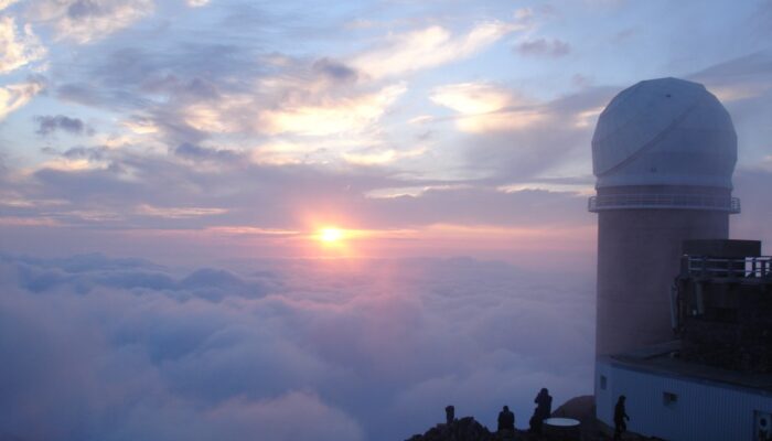
Volcanic Ash as an Active Agent in the Earth System (VA3): Combining Models and Experiments; Hamburg, Germany, 12–13 September 2016 Volcanic ash is a spectacular companion of volcanic activity that carries valuable information about the subsurface processes. It also poses a range of severe hazards to public health, infrastructure, aviation, and agriculture, and it plays a significant role in bioge ...[Read More]
If you didn't find what you was looking for try searching again.
Cryospheric Sciences
Image of the Week – Powering up the ground in the search for ice
In an earlier post, we talked briefly about below-ground ice and the consequences of its disappearing. However, to estimate the consequences of disappearing ground ice, one has to know that there actually is ice in the area of study. How much ice is there – and where is it? As the name suggests, below-ground ice is not so easy to spot with the naked eye. Using geophysical methods, however, ...[Read More]
GeoLog
GeoSciences Column: Catch of the day – what seabirds can tell us about the marine environment
Off the coast of Germany, a male northern gannet (for ease, we’ll call him Pete) soars above the cold waters of the North Sea. He’s on the hunt for a shoal of fish. Some 40km due south east, Pete’s mate and chick await, patiently, for him to return to the nest with a belly full of food. Glints of silver just below the waves; the fish have arrived. Pete readies himself. Body rigid, wings tucked in ...[Read More]
GeoLog
GeoTalk: The anomaly in the Earth’s magnetic field which has geophysicists abuzz
Geotalk is a regular feature highlighting early career researchers and their work. In this interview we speak to Jay Shah, a PhD student at Imperial College London, who is investigating the South Atlantic Anomaly, a patch over the South Atlantic where the Earth’s magnetic field is weaker than elsewhere on the globe. He presented some of his recent findings at the 2017 General Assembly. First, coul ...[Read More]
GeoLog
Mexico earthquakes: What we know so far
On Friday 8 September 2017 at 04:49 am UTC, a magnitude 8.1 earthquake hit off the coast of Mexico, 87 km SW of Pijijiapan. According to the U.S. Geological Survey, the epicentre was at 15.07 N, 93.72 W at a depth of about 69.7 km. Yesterday, another strong (magnitude 7.1) earthquake hit central Mexico, 55 km SSW of the city of Puebla and 120 km south of Mexico City. Despite the lower magnitude, y ...[Read More]
GeoLog
Imaggeo on Mondays: What happens to mines when they become redundant?
When the minerals run out, or it is no longer profitable to extract the resources, mines shut down. Prior to issuing a permit for the exploitation of a resource, most regulators require assurance that once the mine closes it, or the activities carried out at the site, will not present a risk to human health or the environment. Ongoing monitoring of a mine once it is decommissioned is required to e ...[Read More]
Biogeosciences
Investigation of methane emissions in marine systems
Ever wondered how we can measure methane emssions from the seafloor ? And ever wanted to steer a mini submarine remotely operating vehicle (ROV)? Well here´s your chance! Have look at this blog post on analyzing methane emissions using ROVs and you´re ready to embark! The goal is to determine when the gas leak started and how the fluid flow systems work. With our research, we can contribut ...[Read More]
Solar-Terrestrial Sciences
Miho Janvier – The Quest for Solar Storms
In this month’s (first ever for our blog) Life of a Scientist interview, we are very happy to talk to Dr Miho Janvier, a Researcher at the Institut d’Astrophysique Spatiale in Orsay (France), whose work has shed some light on the understanding of solar eruptions and coronal mass ejections (or solar storms) from their birth in the Sun’s corona to their evolution in interplanetary space ...[Read More]
Cryospheric Sciences
Image of the Week – ROVing in the deep…
Robotics has revolutionised ocean observation, allowing for regular high resolution measurements even in remote locations or harsh conditions. But the ice-covered regions remain undersampled, especially the ice-ocean interface, as it is still too risky and complex to pilot instruments in this area. This is why it is exactly the area of interest of the paper from which our Image of the week is take ...[Read More]
GeoLog
Mapping Ancient Oceans
This guest post is by Dr Grace Shephard, a postdoctoral researcher in tectonics and geodynamics at the Centre of Earth Evolution and Dynamics (CEED) at the University of Oslo, Norway. This blog entry describes the latest findings of a study that maps deep remnants of past oceans. Her open access study, in collaboration with colleagues at CEED and the University of Oxford, was published this week i ...[Read More]