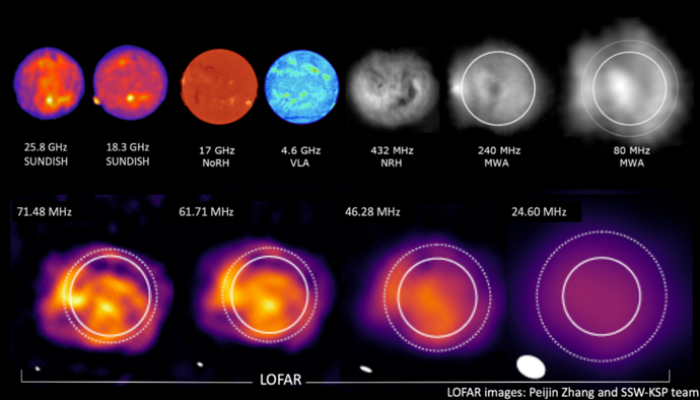
Good news, everyone: 2020 is almost over! Your beloved EGU Geodynamics blog team is taking a 2-week break to recover from this extraordinary year. Or maybe ‘unprecedented’ is a better word? I am – of course – referring to the fact that 2020 has been the most successful blog year to date. Not at all the fact that there was a global pandemic this year. Nope. Absolutely not. T ...[Read More]
If you didn't find what you was looking for try searching again.
Seismology
Earthquake of the month: Russia, deep earthquake M 6.4
November was not highlighted by a large event (> M 7). However, the TOP 3 of the largest earthquakes include a deep focus rupture on November 30th in the Tatar Strait between eastern Russia and Sakhalin Island (Figure 1). This earthquake (M 6.4) occurred at a depth of ~600 km according to different seismology agencies. The moment tensor representation shows an oblique mechanism with a dominant ...[Read More]
WaterUnderground
Elevating diverse voices and groundwater research from around the world with Water Underground Talks
By Tom Gleeson and Viviana Re It has been a challenging year of a pandemic, economic collapse and an ever-increasing awareness of racism, all set against a backdrop of other global challenges including climate change and food security. We believe it is important to link groundwater with these challenges and to stay positive using our science and work as scientists to contribute to a better future. ...[Read More]
Climate: Past, Present & Future
Deep Purple on Ice – Research on the Greenland Ice Sheet During the Pandemic
Insights into the EU project Deep Purple, fieldwork during the COVID-19 pandemic and doing research in a camp on the Greenland Ice Sheet. Written by Ph.D. students Rey Mourot (GFZ Potsdam), Laura Halbach (Aarhus University) and Eva Doting (Aarhus University). On maps, Greenland is shown as a massive white island. This vast ice and snow cover plays a vital role in reflecting incoming solar radiatio ...[Read More]
Hydrological Sciences
Hydrological modelling and pizza making: why doesn’t mine look like the one in the picture?
Is this a question that you have asked yourself after following a recipe, for instance, to make pizza? You have used the same ingredients and followed all the steps and still the result doesn’t look like the one in the picture… Don’t worry: you are not alone! This is a common issue, and not only in cooking, but also in hydrological sciences, and in particular in hydrological modelling. Most hydrol ...[Read More]
Hydrological Sciences
Featured catchment: The Alento Hydrological Observatory in the middle of the Mediterranean Region
Importance of investigating water fluxes in Mediterranean catchments MOSAIC (Modeling and Observing a mosaic of processes for Soil and water resources management in the Alento critical zone and Implementing adaptation strategies to climate and land use Changes) is an interdisciplinary research program that was established by the Soil Hydrology Group of University of Naples Federico II (Italy) and ...[Read More]
Climate: Past, Present & Future
LOESS IN TRANSLATION
Loess is a mineral, aeolian deposit with a range of definitions in literature, which class it as either a sediment, soil, or rock. Some classic texts suggest that “loess is not just the accumulation of dust” [1], and it must include additional processes such as loessification, calcification, pedogenesis, and in-situ weathering. The definition adopted depends on the scientific background and the qu ...[Read More]
Ocean Sciences
Why you (yes, you!) should take part in a hackathon
Back in August, I attended Oceanhackweek 2020. As an oceanographer by trade and free software nerd by heart, I loved the idea of an event that combined the two. I looked forward to learning from other oceanographers and coders, and perhaps giving something back to the free software community. What is a hackweek/hackathon? If you have yet to dip your toes in the wonderful world of free software, th ...[Read More]
Cryospheric Sciences
How small changes can make a big difference: tipping points in Antarctica
As Antarctica’s mass loss increases, the threat of crossing tipping points both in the ice sheet and the surrounding Southern Ocean is increasing. But what actually is a tipping point? Have tipping points already been crossed in the past? And what might the future hold? What do we mean by a “tipping point”? Scientifically speaking, a tipping point is generally understood to be a threshold that, on ...[Read More]
Natural Hazards
The earthquake traffic light
Dr. Laura Gulia is a senior post-doc at the University of Bologna, Department of Physics and Astronomy. She has a strong experience in statistical seismology, seismicity analysis as well as seismic hazard and risk assessment. Recently, she investigated the spatio-temporal evolution of the earthquake size distribution throughout a seismic sequence focusing on the b-value, a parameter characterizing ...[Read More]