This week’s Imaggeo on Mondays is brought to you by the photographer herself, Jana Eichel, who tells us about her expedition to the Mingsha Mountains and the stunning aeolian landforms that characterise the landscape.

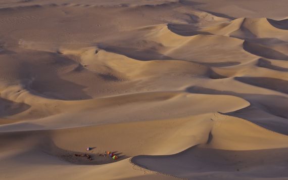
“Star dune in the Gobi desert, Dunhuang, China” by Jana Eichel, distributed by the the EGU under a Creative Commons licence.
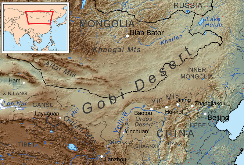
This photo was taken during a journey through Asia in spring 2012, which took me across Bangladesh, India and Nepal through to Western China and into the Gobi Desert. This journey allowed me to appreciate the enormous variety of landscapes in Asia as well as the different cultures. To experience ‘the desert’, which has fascinated me for quite a while, I joined four others on an (ever so slightly touristy) overnight camel trek to the borders of the Mingsha Mountains, where this photo was taken. This megadune field is located south of Dunhuang (Gansu province, China) in the Gobi Desert. The dunes, which are aeolian depositional landforms, are between 60 and 170 m heigh and are formed mostly by westerly and southerly winds. In the neighborhood of this dunefield, the World Cultural Heritage of the Mogao Caves is located, which house a large collection of Buddhist art. There is a fear that they will be overrun by the Mingsha Mountains (megadunes) in the future, which are slowly advancing in this direction.

The Gobi Desert (source).
The image was taken from near the top of one of the large pyramid dunes at the northeastern border of the dunefield. From here you can see the foothills of the Mingsha Mountains with various dune types, which are determined by a multitude of influencing factors, including wind direction variability and sand supply. Our camp in the lower left of the picture puts these huge landforms into perspective.
Most prominently in the foreground next to the camp is a star-shaped dune. These dunes are generally formed by multidirectional winds when there is a large sand supply. These conditionscreate a set of slip faces that project out in multiple directions, such that the dune represents a star – hence the name! Transverse dunes and barchanoid ridges can be seen in the background, where they phase out towards the plains, likely dues to a decreasing sand supply. Dunefields such as this, with a variety of dune types highlight the complexity of geomorphic systems, Aeolian systems, such as the one here are thought to be strongly driven by self-organisation. This means the complex non-linear dynamics of the system do not result in chaos but instead in order: the smallest elements in the system, such as the sand grains, assemble into larger scale objects, such as the dune patterns shown (Dikau, 2006). This emergent behaviour cannot be predicted even if all processes fundamental for the evolution of these dunes are known.
To account for the impressive landscape with its large-scale geomorphic forms, I used a high aperture to give the picture a greater depth. This was amplified by the sunset light, which created long shadows behind the dunes and gave a better impression of the contours of the dunes, which are partly obscured during the day.
By Jana Eichel, University of Bonn
References:
Dikau, R. (2006): Complex systems in geomorphology. Mitteilungen der Österreichischen Geographischen Gesellschaft 148, 125-150.
Jianjun, Q., Ning, H., Guangrong, D. and Weimin, Z. (2001): The role and significance of the Gobi Desert pavement in controlling sand movement on the cliff top near the Dunhuang Magao Grottoes. Journal of Arid Environments 48, 3, 357-371.
Kocurek, G. and R.C. Ewing (2005): Aeolian dune field self-organization – implications for the formation of simple versus complex dune-field patterns. Geomorphology 72, 94-105.
Imaggeo is the EGU’s online open access geosciences image repository. All geoscientists (and others) can submit their images to this repository and since it is open access, these photos can be used by scientists for their presentations or publications as well as by the press and public for educational purposes and otherwise. If you submit your images to Imaggeo, you retain full rights of use, since they are licensed and distributed by the EGU under a Creative Commons licence.
