When it comes to peering beneath the Earth’s surface, geophysicists have an arsenal of high-tech tools at their disposal. But what happens when you need to track something as elusive as underground ice forming and melting in real time? Enter borehole Ground-Penetrating Radar (GPR), the underground detective that helped Peter Jung and his colleagues image frozen subsurface volumes in an experimental geological latent heat storage (LHS) system.
What are GPR and LHS, anyway?
Ground-Penetrating Radar (GPR) is a geophysical method that uses radar pulses to image underground structures. Think of it like an underground ultrasound—except instead of scanning for bones or organs, it’s used to detect changes in soil, rock, and ice.
Geological Latent Heat Storage (LHS) is a technique that stores thermal energy in the ground by freezing and thawing subsurface water. This process can help regulate heating and cooling in buildings and industries.
This study, published in the EGU journal Solid Earth and conducted by Peter Jung, Götz Hornbruch, Andreas Dahmke, Peter Dietrich, and Ulrike Werban, explores how borehole Ground-Penetrating Radar can be used to track freeze-thaw processes in water-saturated glacial sediments. The results? A method that’s cool under pressure, but not without its challenges.
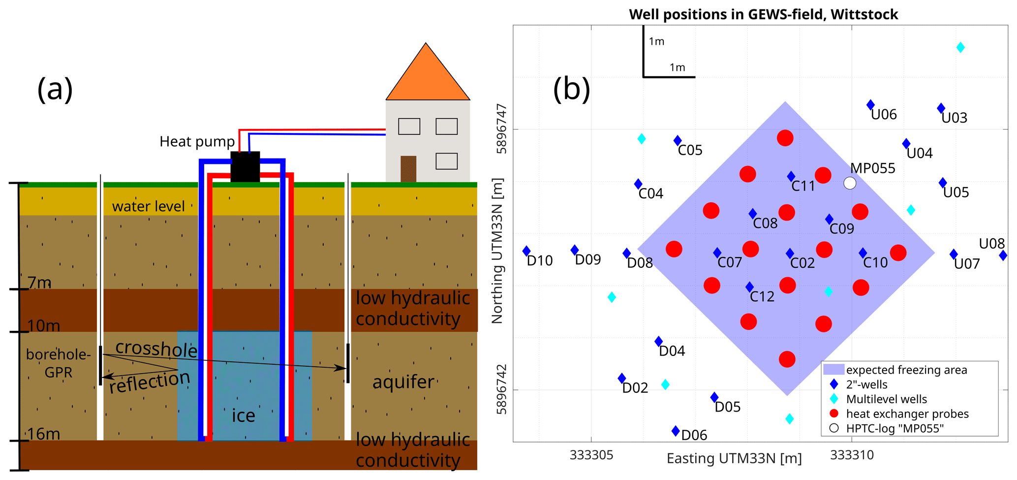
Figure 1(a) Schematic sketch of geological latent heat storage at the experimental site in Wittstock with the concept of GPR reflection and GPR crosshole measurements. (b) Overview of the experimental site with the positions of borehole heat exchangers and observation wells.
How to see ice underground: The methods
If you’re picturing scientists with x-ray vision, think again. Borehole GPR works by sending electromagnetic waves into the ground and measuring how they bounce back when they hit different materials—like frozen or unfrozen sediments. To test the limits of this technology, Jung et al. conducted their measurements in a shallow Quaternary glacial aquifer (basically, an ancient, water-filled sediment layer) during an experimental freeze-thaw cycle.
The team used two primary GPR techniques:
- Zero-offset crosshole profiling: This method involved placing a transmitter and receiver in separate boreholes and measuring how long it took the radar waves to travel between them. This helped estimate the speed of the waves through different materials, which in turn revealed geological layers and ice formation.
- Reflection measurements: Here, the researchers sent radar waves from a borehole into the surrounding sediments and analysed the echoes bouncing back. This allowed them to map the boundaries of the frozen and unfrozen areas with an impressive accuracy of ±0.1 m.
Thanks to these methods, the team was able to track the ice body’s lateral extent in detail, offering crucial insights into the effectiveness of this radar for monitoring underground freeze-thaw processes.
What did they find? The results are ice cold!
Before this study, pinpointing the exact geology of the test site was a bit of a guessing game. But thanks to the clever use of borehole GPR, Jung et al. managed to:
- Map the subsurface layers more accurately by combining the zero-offset crosshole profiling data with a 3D velocity model.
- Image the lateral boundary of the ice body, showing how the frozen volume expanded during the latent heat storage experiment.
- Confirm that borehole GPR can effectively monitor freeze-thaw processes even in the tough conditions of water-saturated sediments.
However, while they could determine the horizontal extent of the ice body quite well, things got a bit trickier when it came to vertical boundaries. The data suggested a clear end to the frozen region at around 16 m depth, but actually pinpointing the top and bottom of the ice layer was a challenge due to signal limitations.
How about the authors’ uncertainty? What could be improved?
Science is rarely a smooth ride, and this study was no exception. Jung et al. identified several limitations that could be improved in future studies:
- Resolution limitations: The GPR’s vertical accuracy was restricted by the Fresnel zone width, meaning finer depth increments weren’t feasible. In simple terms, the system could detect the ice, but drawing a precise boundary was like trying to sketch a sharp line with a thick marker.
- Too many observation wells: While having multiple boreholes is useful, too many at the same distance from the freezing boundary led to interference and reduced imaging clarity. In future experiments, better placement could enhance results.
- Signal-to-noise issues: The water-saturated environment dampened signals, making high-frequency sources impractical. In a perfect world, higher frequencies would improve resolution, but the attenuation of signals in wet conditions meant researchers had to work with what they had.
Despite these hurdles, the study showed that borehole GPR is a promising technique for monitoring underground freeze-thaw processes. With some refinements, it could become an even more reliable tool for tracking subsurface ice dynamics.
Why should you care? Beyond just “cool” science
Understanding underground freezing and thawing isn’t just about satisfying scientific curiosity. It has real-world applications in climate change research, geothermal energy storage, and even permafrost monitoring. If we can better track how subsurface ice forms and melts, we can improve everything from groundwater management to engineering in cold regions.
So next time you hear about underground ice, remember—it might not be visible to the naked eye, but thanks to the work of Peter Jung and his team, scientists are getting a clearer picture of what’s happening beneath our feet. And that’s pretty cool.