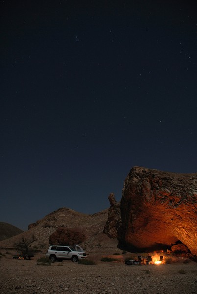
Being an Earth scientist has its perks and camping overnight in a cave under an absolutely stunning unpolluted night sky has to be up there with one of the best! Our Imaggeo on Mondays image is brought to you by Simon Virgo who took the photograph in 2008 during an advanced mapping field course in structural geology in the Batain region of northeastern Oman.
The Batain region extends over an area of approximately 4000 km and is cross cut by a number of east-west trending wadis (valleys that remain dry except during times of heavy rainfall). The Batain Group, consisting of a number of sedimentary and volcanic formations, ranges from Permian to Maastichtian in age. Itis thought to have been deposited in the former ‘Batain Basin’ off eastern Oman and was later destroyed during compressional tectonics from the Group, consisting of a number of sedimentary and volcanic formations, ranges from Permian to Maastichtian in age (299 to 66 million years ago. It is thought to have been deposited in the former ‘Batain Basin’ off eastern Oman and was later destroyed during compressional tectonics during the Cretacous/Paleogene, some 66 million years ago ( boundary (Immenhauser et al.,1998).
ʺThe area is a fantastic playground for structural geologists; it is full of folds (the little cave at which we camped has formed in the hinge of a saddle), small scale faults and large thrust, occasionally associated with megabreccias that show a block size of several meters” explains Simon.
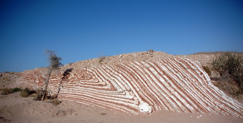
The rocks exposed in the region are mostly radiolarites, seen in the picture above, also taken by Simon. Radiolarites are silica rich, chert-like rocks, formed in shallow or deep waters, which mainly consist of the microscopic remains of radiolarians. The units pictured here are 4–20cm thick alternating beds of red and white cherts. The colouring of the red layers results from organic pigments in the units.
The area is not only geologically rich, explains Simon, “other sights include prehistoric tombs with artefacts scattered on top the hills, a fantastic coast with lots of marine and terrestrial wildlife” and let’s not forget absolutely magnificent unpolluted night sky.
Some related Literature:
Schreurs, G. and Immenhauser, A. (1999), West-northwest directed obduction of the Batain Group on the eastern Oman continental margin at the Cretaceous-Tertiary boundary, Tectonics, 18, doi: 10.1029/1998TC900020.
Immenhauser, A., et al. (1998), Stratigraphy, sedimentology and depositional environments of the Permian to uppermost Cretaceous Batain Group, eastern-Oman, Eclogae Geologicae Helvetiae, 91.2, 217-235.
DeWever and Baudin (1996). Palaeogeography of radiolarite and organic-rich deposits in Mesozoic Tethys, GR Geologische Rundschau, 85, 310-326.
Imaggeo is the EGU’s open access geosciences image repository. Photos uploaded to Imaggeo can be used by scientists, the press and the public provided the original author is credited. Photographers also retain full rights of use, as Imaggeo images are licensed and distributed by the EGU under a Creative Commons licence. You can submit your photos here.


Pingback: Challenges and best practice in online science communication | OpenQuaternary Discussions