Back in January I did a talk at an event called Science Showoff, a comedy night based in London where scientists stand up in front of an audience in a pub and talk about funny stuff to do with their work. I talked about video games. Not any video game however, I talked about The Elder Scrolls V: Skyrim.
For those of you who don’t know what this is, it’s a fantasy role playing video game. It is a great game with some beautiful graphics, especially the scenery; including flora, fauna and rocks. So I did what any other geologist would do. I mapped Skyrim. This means I used all the internet resources I could to find out the locations of every major ore deposit in the region of Skyrim, colour coded them and placed them on a map. My aim was to find out a possible story for the geological evolution of Skyrim.
Like any scientific investigation, you start off with a theory and you commence your investigations to try to prove it wrong. In some cases it is very difficult to prove the theory wrong and so it remains valid, but in most others you do manage to prove it wrong somehow. However, this does not mean that the time and investigations were wasted; instead this process brings up new answers, and questions that scientists investigate further. In the case of mapping the geology of Skyrim, I came up with an initial theory that I presented at Science Showoff, and have since found that my initial theory was probably wrong. This doesn’t dishearten me though, it has proved an interesting journey – if unexpected – that I am sure has engaged and enthused many people.
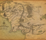
First, I will introduce you to my map of all the major ore deposits in Skyrim. I am by no means claiming that this is accurate and I am certainly not claiming that the final interpretation is accurate either (forgetting for a moment we are discussing a fantasy location). My main reason for taking on this little project was to introduce geology to an audience that may not normally engage with the sciences and so the results of this investigation are not meant to be 100% accurate, but they are meant to be inspiring.
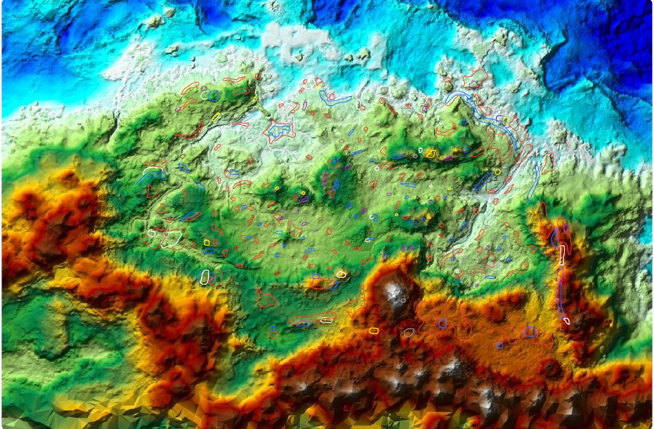
My initial map of Skyrim with ore locations indicated as coloured blobs over the coloured topographic map. Red = iron, blue = corundum, purple = orichalcum, white = quicksilver, grey = silver, yellow = moonstone (click for larger). (Base map modified from one produced by Tim Cook)
For a geologist it is not enough to just have a map of where lots of rocks are. What we need is an understanding of the nature of the earth beneath our feet. In finding out how the rocks got where they are today, we can then build up a history of the evolution of the area – including different environments that one area of land went through over millions of years.
The most common types of rocks we find in Skyrim are iron ore and corundum. In this world, corundum isn’t actually a rock – but it is a rock forming mineral. Rocks are simply amalgamations of other minerals in the form of crystals or grains. In igneous and metamorphic rocks, formed from cooling magma or changed through heat and pressure deep in the crust respectively, the minerals are crystalline in form. In sedimentary rocks the minerals are generally granular – from other rocks that have been ground down as sediments into their individual minerals. Corundum most commonly occurs as a mineral in metamorphic rocks, so we are going to assume that our ‘corundum ore’ is a metamorphic rock of some kind.
It is really important to know in what order the rocks got where they are – which is the oldest and which is the youngest. The map above gives us some clues to the order in which the rocks were laid down. Near the top left there is an area of low topography, and inside this is a red blob with a blue blob in the middle of it. The most likely way for these rocks to be in this formation is that the iron (red) is older than the corundum (blue), so the corundum was deposited after the iron ore. Quicksilver is another name for mercury in our world, the most common ore of which is cinnabar. Cinnabar formation is associated with volcanic activity and hot springs. On the map you can generally see quicksilver (white) associated spatially with corundum and iron ore. If you look closely it appears that quicksilver is usually found on the higher topography, so from this it could be inferred that quicksilver was formed later than both the iron ore and corundum.
Towards the bottom left of the province of Skyrim, in the west, you can see a distinct area where there is a quicksilver blob inside an iron ore blob. This would imply that here the quicksilver is directly on top of the iron – but we know that there should be corundum between these two. This is what geologists call an unconformity. An unconformity represents a missing chunk of time in the geological record. When rocks get laid down – by volcanoes or rivers – it takes millions of years. If we are expecting a rock to be somewhere and see that it is missing, we know we are missing a period of geological time in this area and it presents an interesting puzzle: why has this happened? It could be because of tectonic movements of the crust: raising mountains, eroding them then redepositing other sediments on the eroded mountains, but all we see is a road cutting with some different looking rocks and some missing in the middle. This is one of the most important principles in geology, and for many other subjects. It was through identifying an unconformity that James Hutton discovered the concept of ‘deep time’ in 1788 – that the Earth is thousands of millions of years old.
Orichalcum is a bit of an enigma. Many historical texts in the real world refer to orichalcum and yet there is a lot of dispute over what kind of metallic material it was – was it an ore, an alloy or something else entirely? From around 428 BC in Ancient Greek texts began implying that orichalcum was chalcopyrite, a copper ore that can be formed in a number of ways, but always associated with hydrothermal circulation and precipitation in either a sedimentary or volcanic environment. Orichalcum can be seen on the map adjacent to quicksilver on high topography, indicating this may be the most recent rock to be formed in Skyrim’s history.
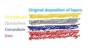
A cartoon of the four main rocks and the order in which they were laid down (oldest at the bottom). (Credit: Jane Robb)
Iron ore in our world is most commonly derived from banded iron formations. These are at least 2,400 million years old! They represent the point from which organisms started photosynthesising and producing oxygen. As these rocks are so old, many of them have been deformed through metamorphism.
Knowing how individual rock types form doesn’t tell us the whole story about Skyrim’s evolution though. The crust of the Earth is mobile – in some places it pushes together (compresses) and in others it pulls apart (extension or rifting), destroying and forming new crust in those areas respectively like a large conveyor belt around the Earth. When different rocks that should be on top of another (like in the diagram above) can be seen next to each other on the same topographic level, we can infer that some tectonic movement has happened. In the east of Skyrim, we see an area of higher topography and several of the different rocks aligned next to each other.
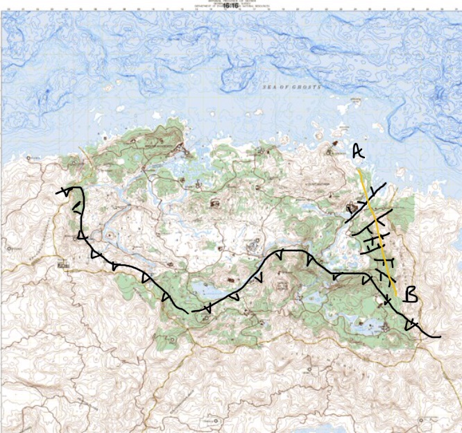
A topographic base map of Skyrim with my annotations of a compressional fault (line with triangles on it, compressing approximately north-south) and extensional faults (lines with little lines on them). The yellow line A-B is showing the location of a cross section cartoon (below). (Map modified from one produced by Tim Cook)
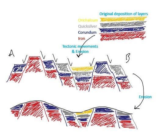
Cross section cartoon A-B of the rocks as they might be underground, showing extensional faulting and erosion. The black ‘ticks’ on the diagram indicate the direction of movement of the land relative to the areas around it. (Credit: Jane Robb)
Skyrim is surrounded to the south and west by mountains, the largest being the Throat of the World. Mountains usually form through landmasses compressing together and bunching up. As this happens the rocks around the area of compression undergo an intense amount of pressure and heat that changes the rocks from their original state – forming metamorphosed rocks. Two of our most abundant rock types are metamorphic – iron ore and corundum. These rocks are also the oldest we see in Skyrim, indicating that for the first part of Skyrim’s history (spanning at least 2 billion years) it was under the sea forming iron ore sediments. A rock, we cannot be sure what it was originally, was deposited on top of the iron ore several millions of years later and then both were squeezed and pushed into mountains and the rest of Skyrim.
Millions of years later, the land started to pull itself apart in the east of Skyrim. Extension is a common trigger for volcanic activity, and combined with what could either have been a warm and wet or marine environment quicksilver and orichalcum deposits began to form above the previously metamorphosed rocks.
In modern day Skyrim, we still see some hot springs and nearby volcanic activity in Solstheim as well as the east being aptly named The Rift.
By Jane Robb, EGU Educational Fellow
Solomon Black
Super cool, was curious as a modder if anyone had guessed at the geology of skyrim, to justify adding more limestone caves in areas; didn’t expect an actual geologist to have done a project! Thank you!
Pingback: #LaRocaLive [2x02] Gracias Mario, pero el fósil está en otro afloramiento - La Roca Filosofal
Elijah Molohon
I was wondering if I could use this imagery in a video I am making for YouTube?
Hazel Gibson
Hi Elijah,
Please contact the blog author to ask permission, email communications@egu.eu and I will pass on their details.
Thanks,
Hazel, EGU Communications Officer
Marco
Have you the topograhy map of the Skyrim land.
Can we open in a civil cad or global mapper or similar?
Pingback: GeoLog | Geosciences Column: Taking a Breath of the Wild - are geoscientists more effective than non-geoscientists in determining whether video game world landscapes are realistic? - GeoLog
Cody
I don’t care that this is three years old; it’s amazing.
I am just starting my geology degree, and I absolutely love this. Thank you for spending so much time on it.
Pingback: The Geology of Skyrim: An unexpected journey | ...
Pingback: The Geology of Skyrim: An Unexpected Journey | Geo-HeritageScience