This week’s Imaggeo on Mondays is brought to you by Gert Verstraeten, who takes us through the formation of some of the striking landscapes in the Mediterranean – the badlands.
For more than 7 years I have been performing research on reconstructing historic erosion rates in the Taurus Mountains in Southwest Turkey. Badlands are heavily eroded landscapes, where soft, clay-rich rocks and soils have been cut back by the action of wind and water.
As in many other Mediterranean environments, intense erosion in can often be related to former human impact on the landscape. Consequently, many degraded landscapes, and especially badlands regions in semi-arid environments are often explained as the result of anthropogenic soil degradation.
In most cases, though, Mediterranean badlands are simply the result of natural processes.

“Badlands of Cappadocia” by Gert Verstraeten, distributed by the EGU under a Creative Commons Licence.
After my last field campaign in August 2012, we travelled to Cappadocia on a small holiday trip to visit the badlands landscape around Göröme. The badlands of Cappadocia offer a spectacular landscape that is the result of natural erosion processes that have been in operation for tens of thousands of years. The badlands are developed in volcanic deposits (lava flows and more importantly ignimbrites) dating roughly between 10 and 5 Million years ago.
Fluvial (river), lacustrine (lake) and aeolian (wind-blown) deposits intersperse the volcanic ones, creating a (sub)horizontal stratification of medium soft to very soft deposits, together with lava flows and pumice deposits, which are more resistant.

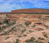
A Hoodoo, also known as a ‘fairy chimney’ in the Grand-Staircase Escalante National Monument rim-rocks, Utah (credit: Wikimedia Commons user Ciar).
During the Pliocene and Pleistocene the Central Anatolian Plateau was incised by up to 400 metres through regressive erosion of the Kizilirmak River from the north. This triggered the formation of badlands in the relatively soft sediments that are easily eroded.
Different landforms developed due to heterogeneities in the stratigraphy. When more resistant deposits (lava flows, pumice deposits, welded ashes) cover softer ones (non-welded ashes, fluvial and aeolian fine-grained deposits), erosion results in the formation of the typical cap-topped ‘fairy chimneys’ for which Cappadocia is so famous. But where only soft ash flow deposits are present, typical so-called ‘sweeping curves’ are formed as seen in the badlands of Cappadocia.
Here, relatively fine-grained ignimbrites are outcropping, immediately northwest of the town of Uçhisar. Exploring the region around Göröme, whether on foot, by car or in a hot air balloon in the early morning, makes discovering all the different erosion features possible. Humans have been occupying this region of natural beauty for millennia but especially since the Byzantine period when villages, churches and monasteries have been carved into the soft rocks.
By Gert Verstraeten, University of Leuven
Imaggeo is the EGU’s online open access geosciences image repository. All geoscientists (and others) can submit their images to this repository and since it is open access, these photos can be used by scientists for their presentations or publications as well as by the press and public for educational purposes and otherwise. If you submit your images to Imaggeo, you retain full rights of use, since they are licensed and distributed by the EGU under a Creative Commons licence.