We model the changes in the geographic location of continents via paleogeographic reconstructions. However, the current methodology for generating these reconstructions is not without problems! Publication of palaeogeographic reconstructions is scarce, probably resulting from the difficulties associated with generating them. Conventional reconstructions are presented as static maps which have poor spatial and temporal resolution. In addition, they are often difficult to replicate as the ‘input data’ used to produced the reconstructions is usually not included in publication. Reconstructions quickly become outdated as the models they are superimposed onto are improved and become more refined.
In Biogeosciences, Wright et al. (2013) present a new method which hopes to overcome some of the issues associated with conventional palaeogrographic reconstructions. Combing the open-source plate motion reconstruction tool, GPlates, with paleobiological data the aim is to uncover spatial and temporal correlations and test the reliability of existing reconstructions. GPlates allows for easy modification and updating of reconstructions and is easily linked to already established models. The new method is tested against the already existing publicly accessible Palaegeographic Atlas of Australia (Totterdell, 2002). It contains 70 palaeogeographic time slices for the Phanerozoic derived from palaeoenvironmental reconstructions, tectonic histories and other geological evidence. In addition, the model is supplemented with fossil indicators from the open-access Palaeobiology database.

Fossil collections (a), palaeogeographical reconstructions taken from the Palaeogeographic Atlas for Australia (b), are reconstructed in GPlates (c) using the Phanerozoic plate motion model (d) and data associations, as per the Emsian example (e) to test and refine the palaeogeographic and plate motion models (click for larger). Source: Wright et al., 2013.
In order to generate their own plate reconstruction in 1Myr intervals in GPlates, for the Australian Phanerozoic, the authors based their relative plate motions on work by Dr. Jan Golonka. The plate motions are derived from palaeomagentic data and Apparent Polar Wander Paths (APW) and are further supported by geological observations, such as location of orogenies and sedimentary basins. A number of taxonomical data were acquired from the Palaeobiology database and assigned GPlates mark-up language so that the data could be included in the new reconstructions. The time scales between the Palaoegeographic Atlas of Australia and the Paleobiology database differed, so they were standardised. The spatial and temporal associations between the palaeogeography and fossil collections were tested for inconsistencies. Where these arose; the fossil collections were taken as the true representation of the palaeoenvironment. For example, if the fossils indicated a truly marine environment, whilst the palaeogeography suggested a terrestrial setting, this was flagged as an inconsistency in the model that needed refining.
The new model has allowed the authors to gain a detailed understanding of the plate tectonic movements of Australia during the Phanerozoic. The article goes into much greater detail than I intend to do so here, I refer you to the article itself if you want more information! During the Cambrian, the new model suggests that Australia spanned equatorial latitudes and formed part of Gondwana. By the Palaeozoic, the Northern margin of Gondwana (North and South China, Tibet and Indochina, amongst others) had detached and this marked the onset of opening and closing of a number of palaeo-Asiatic and Tethys basis. The remaining Pangaea further breaks-up during the Cretaceous, with India and Australia moving northwards, away from Antarctica.

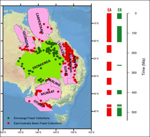
Temporal coverage of eastern Australia basins (EA) and the Eromanga Basin (EB). The data gaps may be related to sampling gaps, orogenic episodes and the influence of glaciations during the late Palaeozoic. Source: Wright et al., 2013.
Palaeogeographic and biofacies data can be embedded into the plate tectonic models in order to uncover inconsistencies and refine the reconstructions. The clear benefits of including palaeobiological data are highlighted during the Emsian time period (402Ma). The paleogeographic reconstruction from the Atlas for Australia proposed a land environment for deposition at this time, whilst the fossil and lithological evidence, suggest a marine environment. Temporal ranges of fossils in relation to the deposition of their associated Formations were problematic and no formations which displayed age disagreements were included in the new model.
Whilst the inclusion of paleobiological data is clearly beneficial to the construction of the models, geographical and temporal gaps in the fossil record, compromise the accuracy of the plate reconstructions. In some cases the gaps in the fossil record are simply due to a sampling bias, but in others it is not clear if the issue is fossil preservation or the environment at the time of deposition. As a result, other data are required as a proxy for biological data. Improvements to the models could be made by including other paleoenvironment indicators such as data from well logs could be included in future models. To further improve the methodology, it is important to remember that sediments and fossils deposition is often confined to basins. In future, it would be valuable to included elevation data or proxies for these into the models. GPlates will also soon allow the incorporation of chronostratigraphic data (Sikora et al., 2006) as well as paleobiological data.
By Laura Roberts Artal, PhD Student, University of Liverpool
References:
Golonka, J.: Late Triassic and Early Jurassic palaeogeography of the world, Palaeogeogr. Palaeocl., 244, 297–307, 2007.
Totterdell, J. M.: Palaeogeographic Atlas of Australia, Geoscience, Australia, 2002.
Sikora, P. J., Ogg, J. G., Gary, A., Cervato, C., Gradstein, F., Huber,B. T., Marshall, C., Stein, J. A., and Wardlaw, B.: An integrated chronostratigraphic data system for the twenty-first century, Geoinformatics: data to knowledge, 397, 53–59, 2006.
Wright, N., Zahirovic, S., Müller, R. D., and Seton, M.: Towards community-driven paleogeographic reconstructions: integrating open-access paleogeographic and paleobiology data with plate tectonics, Biogeosciences, 10, 1529-1541, 2013.
