A French and Algerian study team seeks markers of underwater earthquakes off the Algerian coast. The team also matched the site’s paleoseismic history to land-based historical reports. Wayne Deeker reports.
The Mediterranean Sea represents the boundary between the African and Eurasian plates. Yet the fault segment off the Algerian coast is one of the most active in the western Mediterranean. It is associated with a series of moderate to large earthquakes: about 22 magnitude 6+ events since 856 CE. According to historical records, very large events in Algeria have been rare, though approximately one third of documented earthquakes would have been Mw 7+.
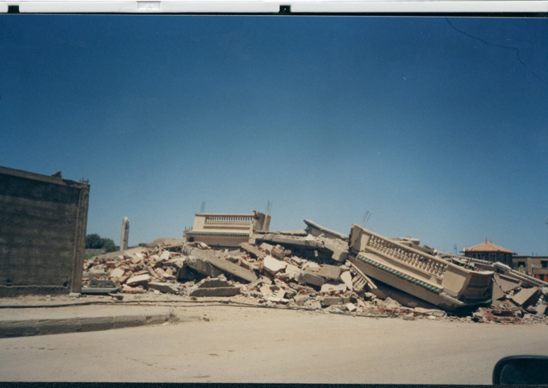
One of the most destructive was also the most recent. In May 2003, the Algerian coast experienced a Mw 6.8 earthquake, centred on the town of Boumerdès. It killed more than 2,300 people, injured some 10,000, and did all the usual structural damage earthquakes do in such countries. It also caused a tsunami which affected the western Mediterranean.

Building damage in the city of Boumerdes, Algeria (Credit: Ali Nour CGS; National Center of Applied Research in Earthquake Engineering)
The authors of a 2012 study published in EGU’s Open Access journal Natural Hazards and Earth System Sciences wanted to understand more about this event and earthquake recurrence intervals in the area. They found interesting clues deep underwater, where the quake likely caused landslides that resulted in almost 30 breaks of submarine telecommunications cables.
The researchers say it is especially worthwhile to investigate earthquake threats in areas that, like those surrounding the Algerian fault, have irregular, long-recurrence patterns because people there will be less prepared than where earthquakes are frequent. Another good reason motivates this research. While 2003 was a very well documented earthquake, most studies of its impact were conducted on land, with little attention paid to the effects and signatures offshore. This is unsurprising, as submarine earthquakes are difficult to monitor in real time, especially during catastrophic events. Therefore, the seafloor signatures of such events have remained elusive because they are occasional, erosive, and are a complex combination of many processes.
The damage to Algerian submarine telecommunications cables provides a clue to what happened underwater in 2003. While cable breaks often denote a definite time and place, pinpointing an event which can be interpreted in context with the landscape, the 2003 breaks were vague in all but one case. The location of the recovered cables also did not correspond to the point of damage, which suggests erosive action of turbidity currents (streams of rapidly moving sediment-rich water that deposit to form so-called turdibite sedimentary beds). Satellite images confirmed this, yet the flow pattern must have been quite complex, apparently following different paths along the underwater scarp system.
Resolving this complexity is challenging and, to do it, the researchers focused partly on seafloor morphology, in particular on the signs of seafloor rupture and instability, such as submarine landslides. Once the researchers started looking, they found the scarps had been affected by numerous landslides. The research team also found evidence of significant sediment transport, confined between salt domes and scarp walls. Sonar images showed signatures of high-energy events: ditches formed by erosion, indicating flow direction, plus perpendicular structures interpreted as pebble or gravel waves. These features probably constitute the sought-after signs of undersea earthquake activity, which can now be matched to other sites.
Direct sediment sampling compliments the scans. At the foot of the scarp slopes, the sediments are too mixed up to reveal any bedding that might be dated. Further out, this is not the case, and the presence of turbidite beds alternating with another type of sedimentary deposit allows for some cautious dating of those layers. Preliminary results, from layers within the upper 1.5m of the core, show at least eleven turbidites accumulated during the Holocene, giving an average recurrence interval of about 800 years in this area. This matches the main seismic cycle on land, supporting the view that large earthquakes in Algeria are the main responsible for the large turbidity flows.
The authors concluded that the 2003 cable breaks were, for the most part, caused by the passage of a turbidity current triggered by the earthquake. The likely path of currents depends on the roughness and the irregularities of the sea floor: seafloor scarps in some cases deflect turbidity flow paths, while perched basins may trap them. The scarps seem prone to sediment failure, and are potential additional sources of cable breaks.
By Wayne Deeker, freelance science writer
