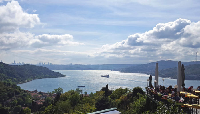
Istanbul – an economic, cultural, and historic centre. Its unique geography, natural resources and beauty have drawn the attention of not only geoscientists but also poets, merchants, painters, sculptors, architects, kings and emperors for centuries. Throughout its history, the city has witnessed the rise and fall of some of the world’s greatest empires. Owing to its geopolitically important location, once conquered, Istanbul was commonly chosen as the capital city. This is the reason why Istanbul is also known by 48 different names in its long history, including Constantinople and Byzantium (even the Chinese had four different names for it). Istanbul is the bridge between Asia and Europe, which makes it possible to have breakfast on one continent and lunch on the other. While the Bosphorus Strait (Figs. 1 and 2) divides the city into Thracian (European) and Anatolian (Asian) parts, it also connects the Black Sea with the Sea of Marmara (Fig. 3) and is known for its mesmerizing scenery.
As the most populous city in Turkey (approx. 15.5 Million), Istanbul has always been popular when it came to settlement. The settlement history of the city goes back to 390 ka. The excavations in Yarımburgaz Cave (north of Lake Küçükçekmece) revealed one of the oldest traces of human culture (Stiner et al. 1996; those inhabitants were not even modern humans) (Fig. 3). The excavations in the cave revealed that it has been inhabited and settled in Palaeolithic, Neolithic and Chalcolitic ages.
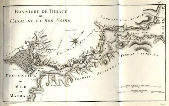
Fig 2. The first geological map of Istanbul drawn by Olivier (1801). Credit: Olivier, G.A. Voyage dans l’Empire Othoman, l’Égypte et la Perse. (1801) .
A small area with complex geology
The geology of the city was mapped for the first time in 1801, by the French entomologist Guillaume-Antoine Olivier (Fig. 2). He differentiated only two rock types in his map, and while this may seem rather inadequate now, we need to keep in mind that it is the first geological map of a city in the world. It was a beginning, after which we learned a lot. Let’s have a look at what we have discovered since:
The geological history of Istanbul is closely related to the scuffle between Eurasia and Africa (back in geological time these were also known as Laurasia and Gondwana-Land, respectively). The continuous convergence between these two continental plates consumed the ocean in between by the process of subduction. When the oceanic lithosphere was consumed, the collision of the two continental masses was inevitable. This led to formation of mountains, uplift of the area and subsequently its erosion. This erosion is the reason why the sedimentary record of Istanbul is incomplete. Although the geological record has blanks in it, geologists can still recover the history, because of the traces that oceanic lithosphere leave behind. Through the study of the remnant geological record we know that Istanbul was involved in three major mountain building episodes, namely the Hercynian (330-300 million years), the Cimmeride (230-100 million years) and the Alpide (90 million years to the present-day) orogenies. The Istanbul region is referred to as the western part of the Istanbul Zone, starting from the Strandja Mountains (Fig. 3) in the west reaching to Zonguldak (Fig. 7) in the east. This zone is a part of a bigger continental fragment, called the Rhodope-Pontide Fragment. It consists of an old (≥540 million years) basement and is overlain mostly by sedimentary rocks, some of which are very rich in fossil content (Lom et al. 2016; Fig. 4) while the northern part of the city is dominated by the volcanic rocks and tuffs (Fig. 5).
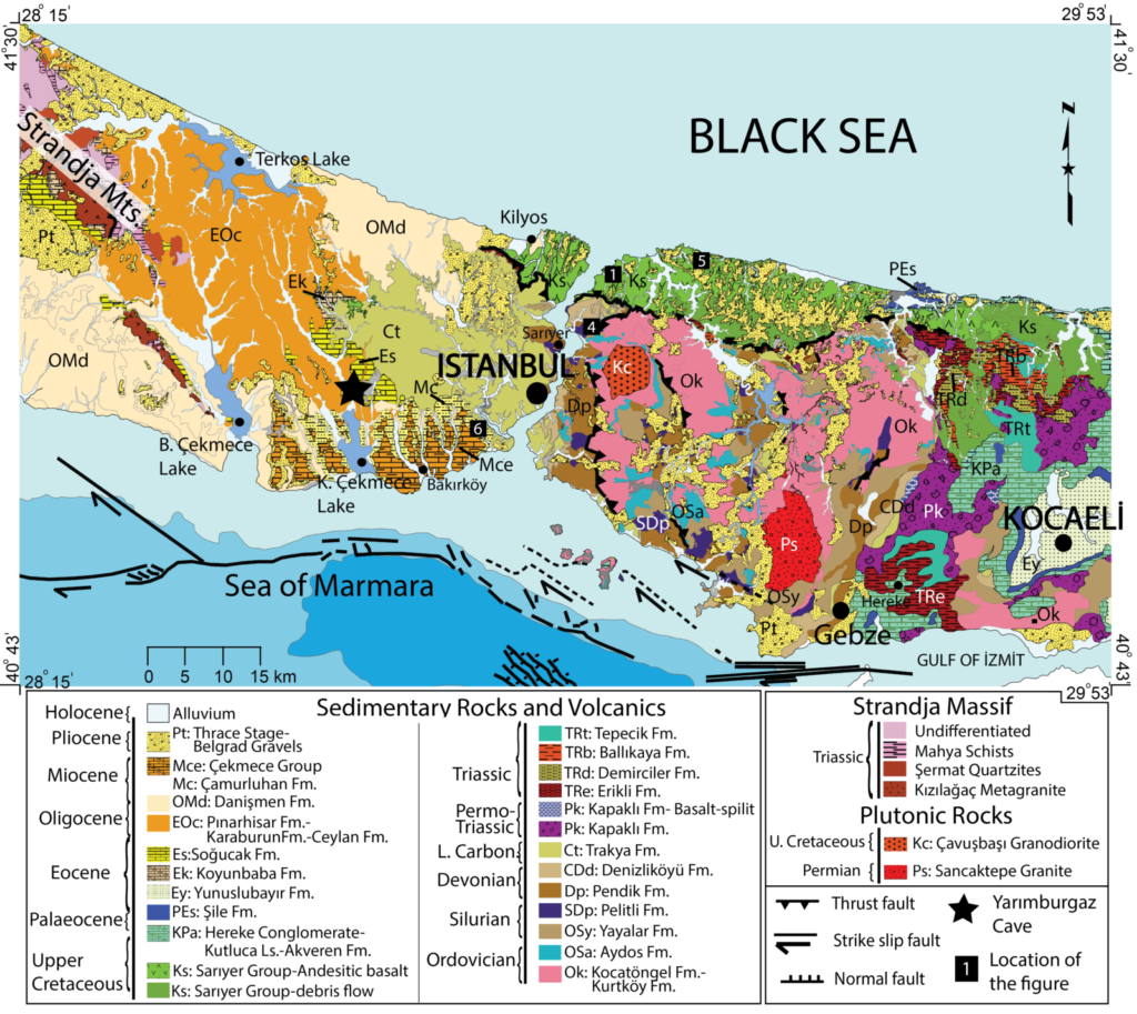
Fig 3. Geological map of Istanbul and its surroundings. Modified from Lom et al. 2016.
These rocks can not only be observed in the field, but also in ancient buildings throughout Istanbul. The ornamental stones (e.g. the Hereke Puddingstone, the Sarmatian limestones) have been frequently used to decorate floors and columns of monumental buildings, such as churches, mosques, palaces and shrines of the city (Fig. 6). The “Historical Peninsula of Istanbul” is chock full of such monuments from the past. Besides their historical significance, the Walls of Constantinople, Hagia Sophia, Galata Tower, Topkapı Palace and many other touristic sites hold record of the rich geological history of the region. Building materials are not only locally sourced but had been brought from other parts of world as well, so that your excursion may take you as far afield as Italy, or Egypt.
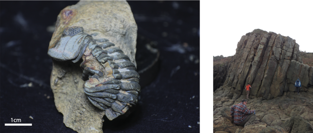
Fig 4 (Left). An almost complete trilobite (an extinct marine animal) fossil of Devonian age (390 million years old) (for the location see Nr.4 in Fig. 3). Credit: Semih Can Ülgen. Fig 5 (Right). ~70 million years old volcanic rocks in the northern part of the city. Their columnar appearance creates a beautiful scenery along the Black Sea coast. These rocks were formed as a part of a volcano. Credit: Nalan Lom.
Shaping the City
The continued convergence between Eurasia and Africa plates resulted in the formation of two major weakness zones in Anatolia. The most active and dangerous one is the North Anatolian Fault Zone. It formed along the former suture along which oceanic lithosphere was consumed during the Cimmeride and Alpide collisions. Istanbul and its province have experienced several devastating earthquakes caused by North Anatolian Fault. Since the 18th century, these earthquakes have been recorded more precisely (1719, 1754, 1766, 1766, 1894, 1912 and 1999) (Pantosti et al. 2008). The latest 1999 Izmit (M 7.4) earthquake caused >30,000 deaths in the neighbouring city of Kocaeli.
The twentieth century earthquake sequence shows a migration westward along the North Anatolian Fault since 1939 (Erzincan earthquake; eastern tip of the North Anatolian Fault, 150 km west of Karlıova), and created surface ruptures of <1000 km (Şengör and Zabcı 2019, Fig. 7). Only the segments in the Marmara Sea south of Istanbul (Fig. 3) are left unbroken, which reminds us how vulnerable the city is due to its location.
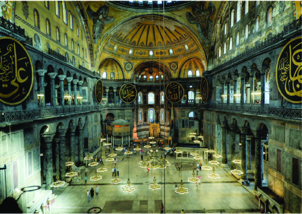
Fig 6. Interior of the Hagia Sophia, which now is a museum. The floor and walls are decorated with marble (Marmara island), limestone (eastern Istanbul), ophicalcite (Italy) and red porphyry (Egypt). Credit: Angı, S. DergiPark (2015).
Although destructive, the North Anatolian Fault helped to create a magnificent and unique landform: the Bosphorus Strait. The 32 km-long Bosphorus Strait curls gently between Sea of Marmara and Black Sea (Fig. 7). The low salinity waters of the Black Sea (1.8%), which formed as a result of continuous water inflow from the rivers and excess of precipitation, are transported to the Mediterranean through the Bosphorus and Dardanelles straits by the main surface current. Meanwhile, the counter-current below the surface, flowing from south to north, brings saline water from the Aegean and Sea of Marmara (3.6%) to the Black Sea (Ünlüata et al. 1990).
The Bosphorus Strait is referred to as the ‘necklace of Istanbul`. It brings life and joy to the city. People of Istanbul love to spend their time along its shore. They go fishing, jogging or simply to sip a cup of Turkish coffee or tea. Beyond its beauty, it also has a strategic importance from a commercial and military point of view. The Bosphorus Strait has always been one of the most important gateways for Bulgaria, Romania, Ukraine, Russia and Georgia to reach the Mediterranean Sea. History has witnessed numerous battles to gain control over this passage, both in modern history and in antiquity.
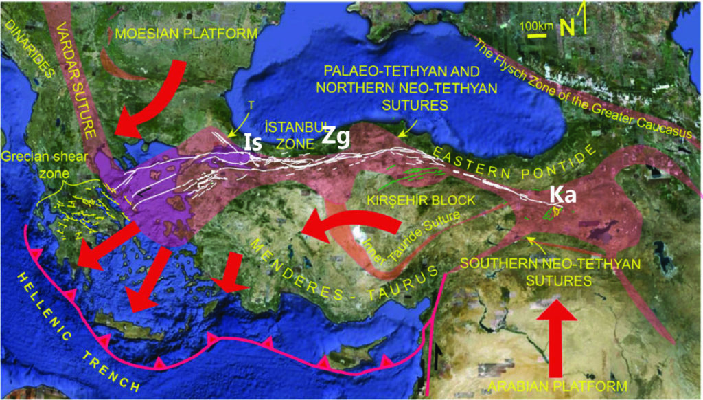
Fig 7. A simplified figure showing the tectonic setting and suture zones of Turkey. White lines show the North Anatolian Fault, red arrows show the modern plate motion relative to fixed Eurasia (Is: Istanbul, Zg: Zonguldak, Ka: Karlıova). Credit: Şengör, A.M.C. and Zabcı, C. Landscapes and Landforms of Turkey (2019).
Talking about antiquity and the city: Istanbul’s recognition is as ancient as human civilization, and is traditionally connected with Greek mythology. According to the myth, Zeus fell in love with Io, daughter of Inachus and the Oceanid Melia. To hide his affair and to protect her from the wrath of Hera, Zeus changed Io’s form to a white heifer. She wandered all over the world, crossed the Ionian Sea, crossed the Thracian Strait that was thereafter known as the Bosphorus (Ox-Ford; meaning passage of the cow), and at last reached Egypt, where she was restored to her original form.
There are many flourishing cities in the world.
But you´re the only one who creates enchanting beauty.
I say, he who has lived happily, in the longest dream,
Is he who spent his life in you, died in you, and was buried in you.Yahya Kemal Beyatlı
Written by Nalan Lom and Derya Gürer
Edited by Elenora van Rijsingen
References
- Lom, N., Ülgen, S.C., Sakinç, M. and Şengör, A.C., 2016. Geology and stratigraphy of Istanbul region. Geodiversitas, 38(2), pp.175-195.
- Olivier G. A. 1801. Voyage dans l’Empire Othoman, l’Égypte et la Perse. Tome premier. H. Agasse, Paris, xii + 432 p.
Pantosti, D., Pucci, S., Palyvos, N., De Martini, P.M., D’Addezio, G., Collins, P.E.F. and Zabci, C., 2008. Paleoearthquakes of the Düzce fault (North Anatolian Fault Zone): Insights for large surface faulting earthquake recurrence. Journal of Geophysical Research: Solid Earth, 113(B1). - Angı, S., 2015. Natural Stones Used in Hagia Sophia and Their Present Conservation State. DergiPark. Vol 14, pp. 43-57.
- Şengör A.M.C., Zabcı C. (2019) The North Anatolian Fault and the North Anatolian Shear Zone. In: Kuzucuoğlu C., Çiner A., Kazancı N. (eds) Landscapes and Landforms of Turkey. World Geomorphological Landscapes. Springer, Cham.
- Stiner, M.C., Arsebük, G. and Howell, F.C., 1996. Cave bears and Paleolithic artifacts in Yarimburgaz Cave, Turkey: dissecting a palimpsest. Geoarchaeology, 11(4), pp.279-327.
- Ünlülata Ü., Oğuz T., Latif M.A., Özsoy E. (1990) On the Physical Oceanography of the Turkish Straits. In: Pratt L.J. (eds) The Physical Oceanography of Sea Straits. NATO ASI Series (Mathematical and Physical Sciences), vol 318. Springer, Dordrecht.