SSP
Stratigraphy, Sedimentology and Palaeontology

sedimentology

Unlocking the Secrets of Ancient Estuarine Deposits

Unlocking the Secrets of Ancient Estuarine Deposits

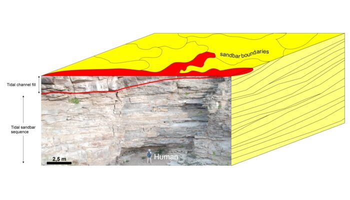
In recent months, I had the opportunity to work on a project analysing subsurface data from a rock sequence previously interpreted as the product of an estuarine depositional environment. The client sought subsurface maps to characterize the spatial distribution of various geobodies associated with sedimentary deposits typically found in modern estuaries. In other words, the goal was to reconstruc ...[Read More]

Tropical conditions in southern Germany: Investigating the sedimentation of Middle Jurassic shallow marine environments in the South German Basin by cyclostratigraphy

Tropical conditions in southern Germany: Investigating the sedimentation of Middle Jurassic shallow marine environments in the South German Basin by cyclostratigraphy

Most people would not relate Central Europe to a tropical environment today. During the Middle Jurassic (174-163 Ma ago), however, such conditions prevailed in most parts of the nowadays  landmass that was almost completely covered by a shallow epicontinental sea (estimated 0-100 m water depth) except for several emerged areas and islands. During this time, the continent of Pangaea broke apart, as ...[Read More]

The study of sedimentary architecture and topography to reduce Earthquake damages: a sedimentological perspective on the Kahramanmaraş earthquakes

The study of sedimentary architecture and topography to reduce Earthquake damages: a sedimentological perspective on the Kahramanmaraş earthquakes

The area were most collapses occurred is a former alluvial outlet for the drainage of water and sediment from the upper parts of the Ahir Mountain When it comes to earthquakes, the nature of the Earth surface geology and its geometry is critical to understand the intensity and type of motion of the ground where we live. Of course, other factors matter when assessing the risk of damage in human-mad ...[Read More]

The digitalization of sedimentary outcrops

The digitalization of sedimentary outcrops

From sketches to first photos Knowledge of geology and, in particular of sedimentology, has successfully been transferred and shared for hundreds of years through sketches. Like a botanist or zoologist, a geologist is able to record data from the field with just a paper and a pencil in the form of drawings (see one of the earliest published sketches of an outcrop in Figure 1). Geological maps and ...[Read More]