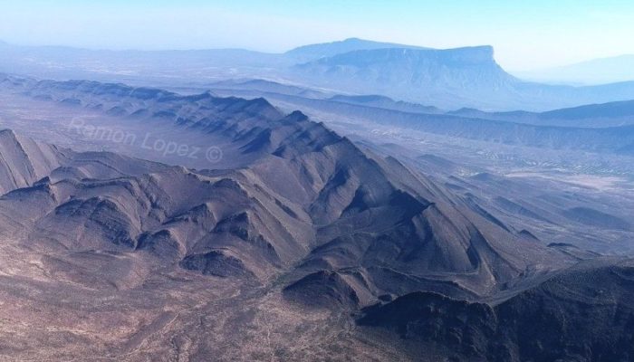
There is a place in the NE of Mexico where anyone can learn heaps about the dynamics of the ground beneath our feet while enjoying the wonders of the desert. Geologists call the area ‘La Popa Basin’. La Popa means “The Bow”, a name that comes from the shape of one of the mountains in this area, which resembles the front part of a very large boat. This place is a perfect training field for geologists and engineers who work for hydrocarbon industry and projects on the capture and storage of greenhouse gases. There are superb exposures of not only salt but, more importantly, of sedimentary rocks where oil, gas and water can be either extracted or stored. In any case, the place is very eye-catching for many people regardless of their personal interests: There is a plethora of cactuses and other amazing desert plant species on an arid landscape, herds of wild horses, a series of mountain ranges encircling the area and … salt, loads of salt. One can walk over 3 km2 of white (CaSO4 ± 2H2O). Remember that ‘salt’ can appear in many other chemical forms apart from table salt (NaCl). If you go to La Popa, take this advice: wear sun glasses and protect yourself with sunscreen. This salt reflects the sunlight as if you were skiing in the Alps.
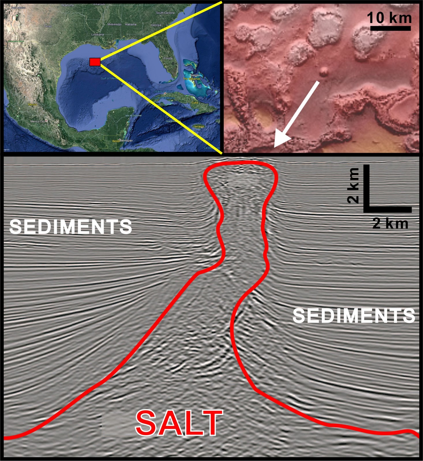
Figure 1. The seismic image at the bottom shows a vertical 2D section of Auger Diapir. This salt diapir has reached the seafloor surface at the north of the Gulf of Mexico, as the BOEM (2020) bathymetry imagery shows. The salt moved upwards creating a bulge or dome (see Google Earth capture at the top right). Seismic image modified from Hearon et al., 2014.
So, how did all this salt get there? To answer this question, it is necessary to explain the formation of the salt deposits but also something else that might be surprising: how it moves underground. Massive volumes of salt are common in the underground all around the world; particularly beneath the seafloor next to coastlines but also on the continents. Most of the ancient salt deposits precipitated on ancient sea floors due to changes in temperature, relatively high-evaporation rates of water and other physical and chemical processes. Salt piled up year after year creating deposits up to several hundred of meters thick. When salt precipitation ceased, these deposits got covered over time by mud, sand or sometimes even lava flows. The whole process typically takes several millions of years. Some of these salt deposits can move underground. These movement can be observed in underground salt mines and seismic data shows evidences of salt movement sideward, upward, and even downward! (Figure 1).
How is this possible? Main controlling factors are the Earth’s gravity field, density differences of sediments and rocks, and the movement of our continents. Simply put, salt tends to be less dense than the sediment or the surrounding rock, which cause the salt to flow over long terms. Such flow rates are comparable to the movement of glaciers, where ice also moves very slowly. The role of density in the upward movement of salt is an analogue to oil in water. If one introduces oil with a dropper at the bottom of a glass filled with water, the drop of oil will quickly move to the water surface. A common mistake is to think that is the oil that moves actively upwards. In fact, it is the water that is ‘pushing’ the drop of oil upwards. This is because water weighs more than oil, so it is moved by the gravity field to a position closer to the Earth centre. This may look rather trivial, but it is probably counterintuitive for most people. If we have a mass of salt surrounded by denser rocks and sediments, the latter will try to get beneath the salt. But as you can imagine, it is not easy for solid rock to flow like water does. Rocks are solid and they cannot move easily and push salt up. This means that salt can only move if either something else encourages those rocks to displace or if space is created for the salt to move. Tectonics is therefore an important process in salt movement, as it is able to displace vast amounts of rock volumes. Both extensional and compressional tectonics can result in the reduction of the thickness of crust and hence a reduction of weight on underlying salt layers. The buoyancy of salt would eventually facilitate the rise of salt (e.g. in pull-apart basins). Tectonic processes also form fractures that behave as conduits for salt to move along.
La Popa Basin is unique in that it exposes so clearly masses of salt that moved upwards through the Earth’s crust. One of these salt masses, named El Gordo Diapir (‘The Fat’), is probably the one that best exposes both its salt deposits and the surrounding sedimentary rocks (Figure 2). Compressive forces related to the opening of the Gulf of Mexico formed folds and fractures and squeezed the salt upwards.
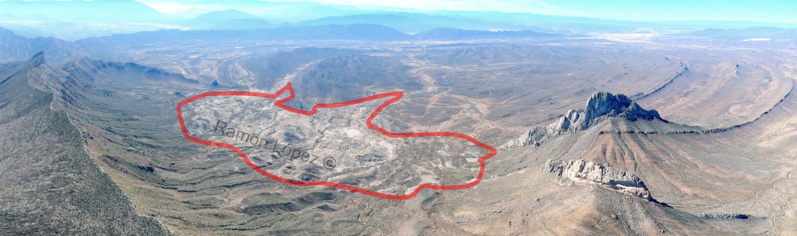
Figure 2. Aerial view of the El Gordo Diapir (encircled in red). Credit: Ramon Lopez
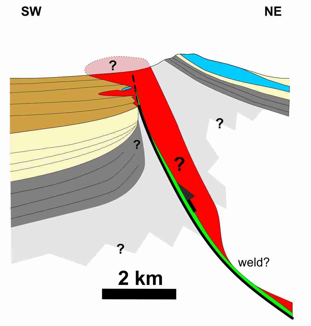
Figure 3. Cross section of the El Gordo Diapir from recent detailed mapping in the area. Salt in red. Credit: Ramon Lopez
Concurrently the movement of the salt deformed its adjacent sedimentary rocks. All these tectonic features in the form of folds and fractures at wide range of scales can be observed in the El Gordo Diapir area. The very diapir is spatially associated with a thrust anticline that once was part of a submarine fold and thrust belt (Figure 3). This makes it great analogue of petroleum plays related to this type of tectonic setting (e.g. Salinas Basin, Gulf of Mexico). This is one of the few places where we can observe and study the complex interplay between salt movement and tectonics. It is a natural laboratory for the oil and gas and even mining industry, but also for projects that intend to store greenhouse gases or radioactive waste within salt giants. It is an amazing fact that these large salt reservoirs play a vital role in tackling modern energy demands, as well as a tool to fight the climate change.
References:
“BOEM Northern Gulf of Mexico Deepwater Bathymetry Grid from 3D Seismic”. Bureau of Ocean Energy Management, 4 November 2020, https://www.boem.gov/oil-gas-energy/mapping-and-data/map-gallery/boem-northern-gulf-mexico-deepwater-bathymetry-grid-3d.
Hearon, T.E., Rowan, M.G., Giles, K.A. and Hart, W.H., 2014. Halokinetic deformation adjacent to the deep-water Auger diapir, Garden Banks 470, northern Gulf of Mexico: Testing the applicability of an outcrop-based model using subsurface data. Interpretation, 2(4), pp.SM57-SM76.
Websites of interest:
Carbon Capture and Storage: https://ec.europa.eu/clima/policies/innovation-fund/ccs_en
European Project on the Mediterranean underground salt deposits: https://www.saltgiant-etn.com/
William W. Little
A very informative and nicely illustrated article. I have been to the El Gordo Diaper with Ramòn. He has done a great work in that region.
Cecilia Roldan
Excelente explicación y trabajo…
Ramon Lopez
muchas gracias Cecilia! cheers.
André Burnol
instructive and well illustrated post, thanks.
Ramon Lopez
Many thanks André! Hopefully I will write again about this topic…