Benedikt Braszus – PhD student at Karlsruhe Institute of Technology, Germany – takes us on a seismic field trip to tropcial Ecuador.
Scientists from Géoazur (CNRS/IRD/Observatoire de la Côte d’Azur/Université de la Côte d’Azur), Karlsruhe Institute of Technology, Instituto Geofísico / Escuela Politécnica Nacional (IG-EPN, Quito), Instituto Oceanográfico de la Armada del Ecuador (INOCAR, Guayaquil) and Imperial College of London have joined the French research vessel l’Atalante on an expedition along the coast of Ecuador. The expedition, called HIPER2 which stands for High Resolution Imaging of the subduction fault in the Pedernales earthquake rupture zone, is the second part of a field campaign that started in March 2020 but was interrupted by the COVID pandemic after only 10 days at sea. Two years later, we now continue with our campaign to explore the Ecuadorian subduction zone from 13 March to 14 April 2022.
The coast of Ecuador near the town of Pedernales was hit by a magnitude 7.8 earthquake in April 2016. This was the strongest earthquake to affect Ecuador in 70 years, causing hundreds of victims and economic losses exceeding 500 million dollars. This earthquake was caused by the sudden rupture of the megathrust fault at a depth of 20 km. The rupture extended over an area of 100 x 30 square kilometer and caused violent shaking in the Pedernales region.
An international team from Ecuador, France, USA and UK deployed a network of seismometers on land and on the sea bottom directly after the earthquake. The collected seismic data complements the seismic and geodetic data collected by the national geological survey of Ecuador and revealed the complex slip behaviour of this part of the Ecuador subduction zone. The shallow part of the megathrust fault is characterized by slow slip earthquakes that can last from a few days to months and don’t generate shaking (they are aseismic). These exotic slip events are still poorly understood but play an important role in the seismic cycle that governs the periodic loading and release of stress along the megathrust fault. In Ecuador they are unusually shallow and can therefore be studied more easily than in other subduction zones.
The objective of the HIPER2 campaign is to understand the transition from seismic to aseismic rupture and the role of fluids which are thought to be the key controlling parameter governing the change between seismic and aseismic slip. We are currently deploying ocean bottom seismometers in a grid pattern covering part of the source region of the Pedernales earthquake and a region where slow slip has been observed. The seismometers will record seismic waves generated by airguns towed by the l‘Atalante. Analysis of the data will provide a 3D image of the subduction zone. In a second part we will redeploy the seismometers along two dense lines/profiles covering different portions of the subduction zone (see Figure below). Analysis of the data from these profiles together with our tomographic images will allow us to decipher the physical properties of the megathrust fault change laterally and with depth.

The track lines show the location of the planned profiles of the active experiment with the research vessel L‘Atalante near the coast of Ecuador with locations of ocean-bottom seismometer locations (A01-H04).
Additionally, a team of scientists from the Karlsruhe Institute of Technology and the Instituto Geofísico / Escuela Politécnica Nacional (IG-EPN, Quito) have deployed 100 geophones along the Ecuadorian coastline from Canoa in the South to Esmeraldas in the North. This will provide onshore records of the seismic waves emitted by the airguns and therefore further enhance the data set based on which the structure of the region will be modeled.
For more details on the field deployment, check out the interview with Benedikt Braszus below, a PhD candidate at the Karlsruhe Institute of Technology in Karlsruhe, Germany, that starts below.
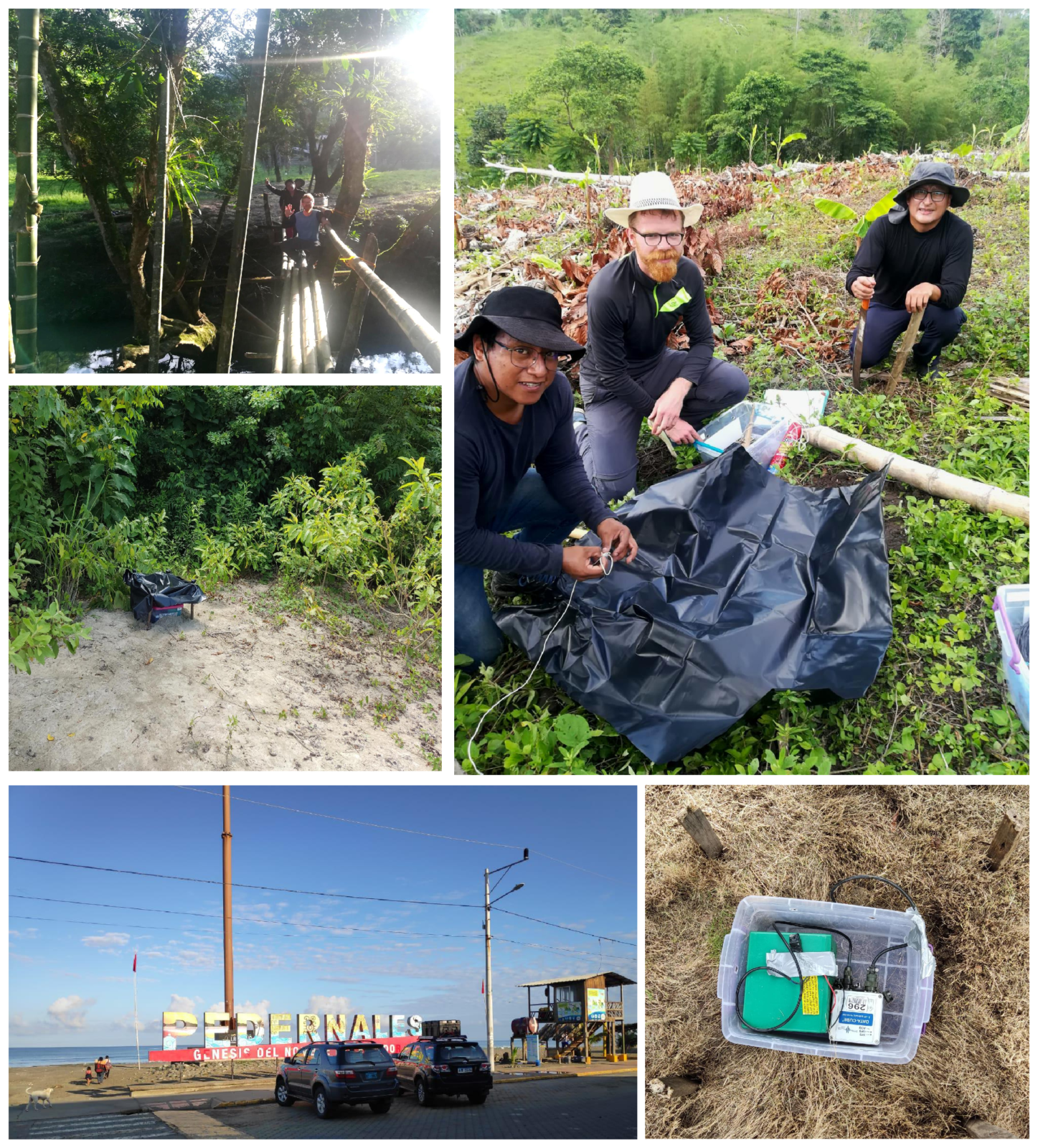
Further impressions of the field work. Photos: Cristian Viracucha & Benedikt Braszus.
Interview with Benedikt Braszus
Now that we have an overview of the project and its scientific intentions we would like to ask you some questions regarding the deployment of the temporal land stations which you were planning and carrying out.
What was your approach to find suitable locations for the deployment?
Due to security reasons, we only installed stations on private property with the permission of the owners. We had already set up stations in the exact same area two years earlier until the corresponding research cruise was cancelled on short notice while already operating due to the evolving pandemic. So, we already knew the region and still had the contact information and coordinates of the farms where we previously installed our instruments. The owners were all very collaborative and approved a re-installation in their properties again. Compared to the last experiment, we densified our network towards the coast thus it was necessary to find additional suitable locations towards the coast. Here, we directly approached local farmers with a handout sheet describing the project and our instruments asking for permission to install on their property. In general, the people were very helpful and usually quite interested in what we told them about the project and the seismicity of the region. Most of them still vividly remember the Pedernales earthquake from 2016 and are aware of the seismic hazard of the region they are living in. Only rarely it took more than one approach to find a location to install.
How would the perfect spot to deploy a seismometer look like?
One of the most important things when looking for a location is a minimal level of seismic background noise within the frequency range of interest. Depending on the surrounding area this noise can have several natural and anthropogenic sources of which some of the most common ones are traffic, buildings, animals, rivers or power generators. Excessive vegetation could potentially disrupt the GPS signal, hence the time reference and should therefore be avoided as far as possible. Locations where the soil has been refilled are not ideal either due to poor coupling of the sensor to the ground. Ideally on would position the sensor right on top of solid bedrock, which is not always possible. In the coastal region of Ecuador some areas get flooded during rainy season, so you have to stay away from those as well. A rather practical but nevertheless important point is the accessibility by vehicle and how far you will have to carry all your equipment from where you park your vehicle. On many occasions some of those factors have to be traded off against each other in order to find a safe, well accessible and seismically rather quite spot. Ideally, we installed in farms that were at least a few hundred meters away from the main road. We also avoided places that are constantly exposed to humans or animals e.g. on the edge of a plantation. Several boundary conditions can force you to deviate from this ideal location. While we installed most of our stations on farms, we also deployed sensors on properties of hotels, schools, military bases and back yards of houses in villages.
What type of sensors did you deploy and what was the setup of a fully equipped station?
We deployed a total of 100 three-component geophones (4.5Hz) from the instrument pool of the GFZ (German Research Centre for Geosciences) in Potsdam. Additionally, each station consisted of a digitizer with internal GPS antenna and a 9V battery powering the station for at least 6 month. The batteries are charged using portable solar panels. Digitizer and battery were put in a plastic box to shield them from humidity and then covered by plastic bags for additional protection.
In a few cases, there were animals close-by, thus we also built a small fence around the station to keep them at a distance.

Cristian and Dario finishing the deployment of a seismic station. Photo: Lenny Mejia.
What was your biggest surprise or unexpected challenge in the field?
Overall, everything went very smoothly and we finished ahead of schedule which helped to record all the air gun blasts from the active experiment since we started the deployment with a few days of delay due to customs clearance issues of our equipment. Even though this was not entirely unexpected it was still a minor set-back at the start of the field work. We were very lucky to work together with our colleagues from the Instituto Geofísico of the Escuela Politécnica Nacional in Quito. Years of field work to maintain their own network of seismic stations all over the country gave them a lot of experience and especially knowledge of the numerous gravel and dirt roads off the beaten tracks and their always changing condition based on the rain situation. On many occasions this saved us quite some time being able to find the fastest and safest way to a given location.
One very unexpected challenge occurred while driving on a dirt road towards a farm to install a station. Out of a sudden, cross-country motorcycles were coming at us from both sides of the road racing past us only leaving inches of space between them and our side mirrors. Apparently, we were caught in the middle of a motorcycle race blocking their racing track. Unfortunately, after short consideration, we had to realize that our heavily loaded Toyota Fortuner was in no shape to compete with the very agile two-wheelers in this very challenging terrain. So, we decided to abandon the race track as fast as possible and look for an alternative route to our destination instead.
Another known challenge are the humid and very hot conditions in the coastal area. There is not too much one can do about this other than putting on sun block regularly, wearing a sun hat and refreshing yourself with a freshly squeezed fruit smoothie or milkshake right by the sea every now and then.
What would you do differently when planning or executing such a field operation the next time (e.g. more time for customs, more mosquito protection, more workers, …)?
This time the entire customs process was by far the most time consuming obstacle we had to overcome. Planning in more time for this would reduce the risk of running into time pressure towards the end of the deployment and leave a time cushion for any unforeseen complications in the field, of which we luckily only had very few. Regarding the climate conditions and mosquito protection we were very well prepared, since our colleagues had a lot of experience in the field and also I had been working in this region myself before. Having an additional team of workers of course would speed up the entire field work, but would not decrease the overall workload. This could be an option, though, when you’ve only got limited time and there is more personnel available.
Of course, in retrospect there are always certain things one could have done better or more effectively. Let’s for example take the trade-off between the desired very uniform station distribution and the minimization of the required driving time in the field. A couple of our planned installation points were quite hard to reach due to challenging road conditions. With only very limited time at hand, we sometimes improvised and decided to install the station in a more accessible location. This in some cases meant to put up with a less equal station spacing, but in turn save a lot of time.
What was your personal highlight of the field work?
It is hard to pick one highlight out of all the great memories connected to this trip. One thing I was very happy and grateful to experience was the hospitality and kindness of so many locals. Countless times, we were invited for refreshments, snacks or cakes into their homes after they had watched us sweating our socks off when digging a hole for our sensor in sometimes very dry and hard soil. Another highlight were amazing sunsets that we were able to enjoy right by the shore of the Pacific ocean or even in the sea while swimming after an exhausting day of digging holes and carrying car batteries through the burning sun. This was perfect to recharge or own batteries for the days to come.
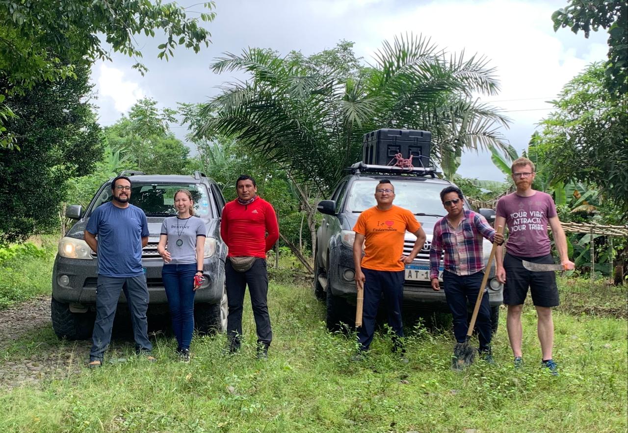
The joint team of IG, EPN Quito and GPI, KIT Karlsruhe after the successful deployment of 100 geophones in the greater Pedernales area in coastal Ecuador. Left to right: Dario Garcia, Lenny Mejia, Cristian Viracucha, Wilson Acero, Ivan Tapa and Benedikt Braszus. Photo: Ivan Tapa.
Many thanks to Benedikt for being our interview partner and provide us
with insights into this exciting field trip to Ecuador.