G
Geodesy

sea level change

Bits and Bites of Geodesy – Satellite radar altimetry: How do we know that sea level is rising?

Bits and Bites of Geodesy – Satellite radar altimetry: How do we know that sea level is rising?

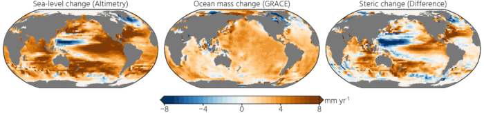
In a previous post, Thomas Frederikse briefly explained how geodesy is used to observe sea level change. In this part of Bits & Bites, Bene delves deeper into the topic. Rising sea levels are one of the consequences of climate change that already impacts people in low-lying coastal regions, and the future prospects are not exactly encouraging as well. We know that rising sea levels are caused ...[Read More]

Want to really understand sea-level rise? Bring in the geodesists!

Want to really understand sea-level rise? Bring in the geodesists!

  A remarkably large number of papers and proposals have sentences like “this study is critical to better project future sea-level rise” in their introduction. Most times this is just marketing to trick reviewers and program managers into believing the work is important. On the other hand, geodetic papers and proposals have some compelling reasons to use this statement: a lot of geodetic tech ...[Read More]