ERE
Energy, Resources and the Environment

Suzanne Hangx

Suzanne Hangx is a post-doctoral researcher at the High Pressure and Temperature Laboratory of Utrecht University, the Netherlands. Her research focusses on fluid-rock interactions and how they affect the mechanical properties of rocks. By breaking rocks on a (more or less) day-to-day basis, she aims to make a contribution to potential solutions of societally relevant earth scientific issues, such as subsurface CO2 storage or surface subsidence induced by hydrocarbon or groundwater pumping. Suzanne is currently the Subsurface Officer of the Energy, Resources and Environment (ERE) Division of the European Geosciences Union (EGU).

Words on Wednesday: River flood risk in Jakarta under scenarios of future change

Words on Wednesday aims at promoting interesting/fun/exciting publications on topics related to Energy, Resources and the Environment. If you would like to be featured on WoW, please send us a link of the paper, or your own post, at ERE.Matters@gmail.com.

***

Budiyono, Y., Aerts, J. C. J. H., Tollenaar, D., and Ward, P.: River flood risk in Jakarta under scenarios of future change, Nat. Hazards Earth Syst. Sci. Discuss., 3, 4435-4478, doi:10.5194/nhessd-3-4435-2015, 2015.

Abstract:

Given the increasing impacts of flooding in Jakarta, methods for assessing current and future flood risk are required. In this paper, we use the Damagescanner-Jakarta risk model to project changes in future river flood risk under scenarios of climate change, land subsidence, and land use change. We estimate current flood risk at USD 143 million p.a. Combining all future scenarios, we simulate a median increase in risk of +263 % by 2030. The single driver with the largest contribution to that increase is land subsidence (+173 %). We simulated the impacts of climate change by combining two scenario of sea level rise with simulations of changes in 1 day extreme precipitation totals from 5 Global Climate Models (GCMs) forced by 4 Representative Concentration Pathways (RCPs). The results are highly uncertain; the median change in risk due to climate change alone by 2030 is a decrease by −4 %, but we simulate an increase in risk under 21 of the 40 GCM-RCP-sea level rise combinations. Hence, we developed probabilistic risk scenarios to account for this uncertainty. Finally, we discuss the relevance of the results for flood risk management in Jakarta.
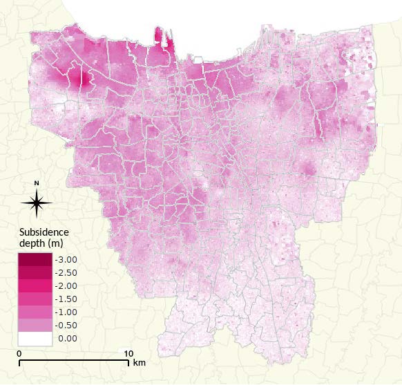
Spatial distribution of projected total land subsidence over the period 2012–2025.

Spatial distribution of projected total land subsidence over the period 2012–2025.
 

Row, Row, Row Your Boat: Predicting Flood Impact with Aqueduct Global Flood Analyzer

Row, Row, Row Your Boat: Predicting Flood Impact with Aqueduct Global Flood Analyzer

The Aqueduct Global Flood Analyzer of the World Research Insitute is a web-based interactive platform which measures river flood impacts by urban damage, affected GDP, and affected population at the country, state, and river basin scale across the globe. It aims to raise the awareness about flood risks and climate change impacts by providing open access to global flood risk data free of charge.

The Analyzer enables users to estimate current flood risk for a specific geographic unit, taking into account existing local flood protection levels. It also allows users to project future flood risk with three climate and socio-economic change scenarios. These estimates can help decision makers quantify and monetize flood damage in cost-benefit analyses when evaluating and financing risk mitigation and climate adaptation projects.

In short, the results of the Analyzer are meant to provide a first impression of the distribution of risk among countries, provinces, and basins. This provides an indication of risk magnitude, and an impression of the magnitude of future change in risk that can be expected. The results should be used to focus attention on particular vulnerable areas and open dialogues on the risks and how they can be managed. The results can certainly not be used for the dimensioning of specific flood protection measures. This would require more detailed and locally calibrated models that include additional information on local conditions, including more accurate river profiles, structures, existing flood protection, reservoir conditions and management during floods, and more accurate information on exposure and vulnerability. It would also require thorough engagement with local experts and stakeholders.

The Aqueduct Global Flood Analyzer was developed in collaboration with Deltares, Utrecht University, the Institute for Environmental Studies of the Free University of Amsterdam and the Netherlands Environmental Assessment Agency.

Living with water: Floods in the Netherlands

Rising sea levels due to climate change. Natural climatic cycles, like El Niño. Land subsidence due to fluid pumping.

There are many reasons that can increase the risk of flooding of cities and other areas. We might not always be able to control it, but is there a way to better predict and prepare for it?

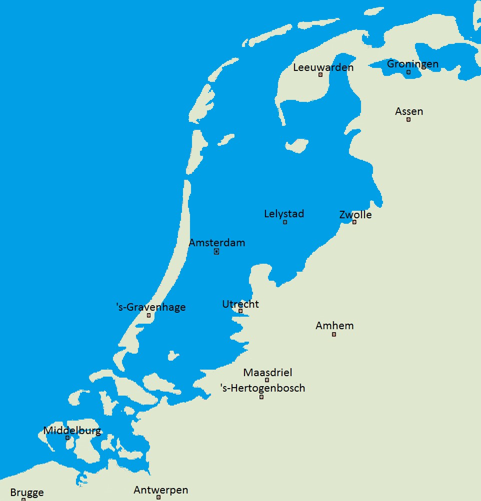
I come from the Low Lands (Netherlands), and that means we are very close to water, living on a delta created by the interplay of the North Sea and a total of four rivers. It has made the Dutch excellent water managers, with most of our current land that lies below sealevel being manmade (the Dutch ‘polders’). With a large part of the country being at or below sealevel (only half is more than 1 m above sealevel!) we have faced many floods in the past.

Without dikes, this part of the Netherlands would be flooded.  Credit:  Wikipedia

Without dikes, this part of the Netherlands would be flooded.Credit: Wikipedia 

The North Sea Flood of 1953 resulted from a storm tide and killed over 1000 people. After that a special committee, assigned to evaluate the potential to reduce the risk of such a flood in the future, developed the Deltaplan, aimed at closing off the estuary mouths in the south of the country to the sea. Nowadays, the Deltaworks, as these storm surge barriers are called, protect the country from high tides during storms. Under normal conditions they remain open to the sea, allowing sea water and the tides to reach inland.

At the same time, sea level rise has meant that we need to continuously re-enforce and broaden existing sea and river dunes. The Rhine River floods annually, resulting in significant economic and property damage. In an attempt to better guide these floods, and decrease their impact, the Room for the River project was started. Within this project, the four main rivers (the Rhine, the Meuse, the Waal and the IJssel) are literally given more room to flood, be moving some of the surrounding dykes broading the flood plain, increasing the depth of the flood plains and removing obstacles.

That’s how the Netherlands is trying to live with its surrounding water. This week, I will be posting a number of interesting papers and articles in relation to this topic. To illustrate if flood risk can be predicted, and what the flood risks are in other parts of the world.

Words on Wednesday: Brief Communication – The dark side of risk and crisis communication: legal conflicts and responsibility allocation

Words on Wednesday: Brief Communication – The dark side of risk and crisis  communication: legal conflicts and responsibility allocation

Words on Wednesday aims at promoting interesting/fun/exciting publications on topics related to Energy, Resources and the Environment. If you would like to be featured on WoW, please send us a link of the paper, or your own post, at ERE.Matters@gmail.com.

***

Scolobig, A.: Brief Communication: The dark side of risk and crisis communication: legal conflicts and responsibility allocation, Nat. Hazards Earth Syst. Sci., 15, 1449-1456, doi:10.5194/nhess-15-1449-2015, 2015.

Abstract:

Inadequate, misinterpreted, or missing risk and crisis communication may be a reason for practitioners, and sometimes science advisors, to become the subjects of criminal investigations. This work discusses the legal consequences of inadequate risk communication in these situations. After presenting some cases, the discussion focuses on three critical issues: the development of effective communication protocols; the role, tasks, and responsibilities of science advisors; and the collateral effects of practitioners’ defensive behaviours. For example, if the avoidance of personal liability becomes a primary objective for practitioners, it may clash with other objectives, such as the protection of vulnerable communities or the transparency of decision making. The conclusion presents some ideas for future research on the legal aspects of risk communication.