There has been considerable disagreement amongst researchers concerning the extent of South Georgia’s ice sheet during the Last Glacial Maximum (LGM). The sub-Antarctic islands (those below the polar front) may have been completely glaciated during previous glacials, and the last largest extent of the South Georgia ice sheet was during the LGM, about 21,000 years ago. But glaciologists don’t agree on the exact size of the ice sheet at that time. There are three main hypotheses: the aptly named big ice, little ice, and the little-big ice hypotheses (Figure 1).
Why is studying South Georgia so important?
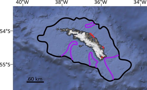
South Georgia is a narrow, mountainous island located in the eastern Scotia Sea (∼54°S, 37°W; Figure 2). South Georgia is 167.4 kilometres (104 mi) long and is a maximum of 37 km (0.9 to 23.0 miles) wide, making it the largest island in the Sub-Antarctic Zone. South Georgia’s position means that its climate is influenced by several different ocean currents. This makes South Georgia a good location to study how the positions of these currents have changed over time. Understanding the Southern Ocean is essential because it plays a pivotal role as a regulator of the global climate system. The currents that surround Antarctica are the only continuous ocean currents in the world. The enlarged size of the ice sheet covering South Georgia in past glacials could have influenced where these currents flowed.

Figure 2: Location of South Georgia and its stunning landscape. Maps from Google Maps. Photo credit: Christopher Michel (Creative Commons Attribution 2.0).
Why is studying palaeoclimate relevant?
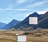
To get some idea of how the climate may change in the future due to anthropogenic forcings, it is necessary to see how glaciers changed in the past. Like much of the world, recent anthropogenic warming has impacted South Georgia’s climate. Glacier change is dramatic in South Georgia, with significant retreat recorded in >90% of its glaciers since the 1970s (Figure 3). To see how much impact man-made warming is having on South Georgia, we must know what the climate history and glacier extent was like in the past. Three ice sheet extents have been hypothesized and are still being debated!

Figure 3: The extent of glacial retreats from glaciers in South Georgia since the 1970s with the red lines representing the 1970s, yellow the 1990s, and the twenty-first century in increasing darkening greens. What this shows is that not only have the glaciers retreated, but the rate at which retreat is happening has accelerated in recent years. Adapted from The South Georgia Geographic Information System.
The big ice hypothesis
Some authors have argued that there was a very extensive ice sheet during the LGM. Clapperton et al. (1989) suggested that before 18 kyr BP (during the LGM), the South Georgia ice sheet extended to the continental shelf edge (where the continental shelf ends and starts to descend to the abyssal plain, the deepest and flattest part of the ocean floor) based on an analysis of terrestrial glacial geomorphology but with limited dating constraints. This extensive “big ice” hypothesis suggests that the glacial history of South Georgia was similar to that of the Antarctic Peninsula, with ice extending to the shelf edge during the LGM, followed by the glaciers’ retreat to their current extent. However, much of this early work lacked any chronological control (Barnes et al., 2016).
Graham et al. (2008) identified terminal moraines (moraines that form at the end of the glacier) at the shelf edge of some of the cross-shelf troughs. These cross-shelf troughs are extensions of the fjords that extend all the way to the shelf edge in places which were curved out by advancing glaciers. However, these moraines are thought to have been formed during more extensive past glaciations. It is possible that the “big ice” scenario did occur but likely in a previous glacial, and the glacial extent during the LGM was much smaller.
The restricted ice hypothesis
Other authors (e.g., Rosqvist et al., 1999; Bentley et al., 2007; Hodgson et al., 2014) have argued in favour of a much smaller ice sheet during the LGM, with its maximum extent restricted to within the inner fjords, especially on the more sheltered eastern side of the island. Detailed examination of the South Georgia fjord glacial geomorphology (geometry of the land) by Hodgson et al. (2014) revealed that glaciers were more extensive before the LGM, with glaciers restricted to the inner fjords during the LGM. The moraines identified by Graham et al., 2008 also correlate with the terrestrial features identified by Bentley et al. (2007).
The restricted (or little) ice hypothesis suggests that South Georgia’s glacial history is like that of Patagonia, where earlier glaciations extended beyond that seen during the LGM. Hodgson et al. (2014) attributed the more extensive glaciation to older glacial advances, most likely during Marine Isotope Stage 6 (MIS6; the glacial maximum before the last one; 185-135 ka). However, as Barnes et al. (2016) pointed out, this evidence is far from conclusive. It is possible that a larger ice cap existed on the South Georgia shelf but retreated to the inner shelf earlier than previously thought or that cold-based, non-erosive glaciers existed, leaving little or no geomorphological signature (Hodgson et al., 2014).
Hodgson et al. (2014) proposed that the South Georgia ice sheet was relatively restricted during the LGM due to a combination of sea-level control, with lower LGM sea-level causing some glaciers to ground on land within the fjords, and reduced precipitation. One hypothesis is that glacier extent was limited during the LGM because they were deprived of moisture by the more extensive sea ice around Antarctica and stronger Southern Hemisphere westerly winds. Alternatively, the restricted ice-sheet extent may not be related to climate but instead linked to glacial modification of the underlying topography, with numerous previous glacial cycles eroding the valleys and fjords to sufficient depth to reduce glacier length by making it impossible for them to anchor down on the bedrock (Hodgson et al., 2014).
The little-big ice hypothesis
Between these two hypotheses is the “little-big ice” scenario suggested by Barnes et al. (2016) which best fits the current evidence. Benthic (organisms that live on and beneath the sea floor) biodiversity changes during deglaciation measured in sediment cores around the shelf are consistent with extensive LGM grounded ice near the shelf edge in the majority, but not all areas around the South Georgia shelf. One area that mainly remained ice-free was the eastern shelf.
Based on trimlines, lateral and terminal moraines, the following model of environmental and climate changes was summarised by van der Putten and Verbruggen (2005):
- Icecap maximum extent before 18 kyr BP, to the edge of the continental shelf
- Withdrawal of the ice cap to a short distance beyond the present shore between 18 and 14 kyr BP
- Further glacier retreat to within fjords and bays between 14 and 10 kyr BP.
Where I come in
Much of the uncertainty regarding South Georgia’s glacial history is due to the absence of marine geological data and sediment cores encompassing the glacial to post-glacial periods. In my PhD project, I would like to find out more about the evolution of South Georgia’s climate by studying the diatom and foraminifera assemblages (the water column and benthic communities, respectively) and geochemistry (e.g., alkenone analysis to calculate past temperatures and δ13C of the amount of organic matter) over the last 15,000 years – since the last deglaciation.
References
- Barnes, D. K. A. et al. (2016) Biodiversity signature of the Last Glacial Maximum at South Georgia, Southern Ocean. Journal of Biogeography 43(12): 2391-2399
- Bentley, M.J. et al. (2007) Glacial geomorphology and chronology of deglaciation, South Georgia, sub-Antarctic. Quaternary Science Reviews 26: 644-677
- Clapperton, C.M. et al. (1989) Late-Glacial and Holocene glacier fluctuations and environmental change on South Georgia, Southern Ocean. Quaternary Research 31: 210-228
- Darvill, C.M., Bentley, M.J., Stokes, C.R., Hein, A.S. and Rodés, Á. (2015) Extensive MIS 3 glaciation in southernmost Patagonia revealed by cosmogenic nuclide dating of outwash sediments. Earth and Planetary Science Letters 429: 157-169
- Graham, A.G.C. et al. (2017) Major advance of South Georgia glaciers during the Antarctic Cold Reversal following extensive sub-Antarctic glaciation. Nature Communications, 8(14798)
- Hodgson, D.A. et al. (2014) Glacial history of sub-Antarctic South Georgia based on the sub-marine geomorphology of its fjords. Quaternary Science Reviews 89: 129-147
- Rosqvist, G. C. et al. (1999) Late glacial to middle Holocene climatic record of lacustrine biogenic silica oxygen isotopes from a Southern Ocean island. Geology 27(11): 967-970
- van der Putten, N. and Verbruggen, C. (2005) The onset of deglaciation of Cumberland Bay and Stromness Bay. South Georgia. Antarctic Science 17(1): 29-32
Acknowledgements
I would like to thank Dr Sev Kender (University of Exeter) for being my primary PhD supervisor and reviewing this article, Loeka Jongejans (Alfred Wegener Institute) for her comments and suggestions, and Marie Cavitte (Université catholique de Louvain-La-Neuve) for giving me the opportunity to publish an article for the EGU Cryosphere blog.
Edited by Loeka Jongejans and Marie Cavitte
 Jack Wilkin is a PhD student and teaching assistant in Geology at the Camborne School of Mines (University of Exeter, UK). His current research focuses on microfossil assemblages (foraminifera and diatoms) and geochemical proxies from sediment cores from the South Georgia shelf since the last deglacial. Jack can be reached at jack.wilkin@btinternet.com and on his LinkedIn profile.