Greenland, cold as it is, was appropriately front and center in the Cold War. Strategically placed between Europe and North America, the United States sought to maintain and enhance its position on the island so that American missiles and bombers were in striking range of many Soviet targets. Soviet bombers and missiles coming toward North America would streak over Greenland making early warning capabilities on the island crucial. During World War II, Americans defended Greenland under treaty with Denmark. The U.S. military learned the hard way that living in, rather than on, the ice sheet was far less risky and far more comfortable. They carried that knowledge into the Cold War.
Living in an Ice Sheet
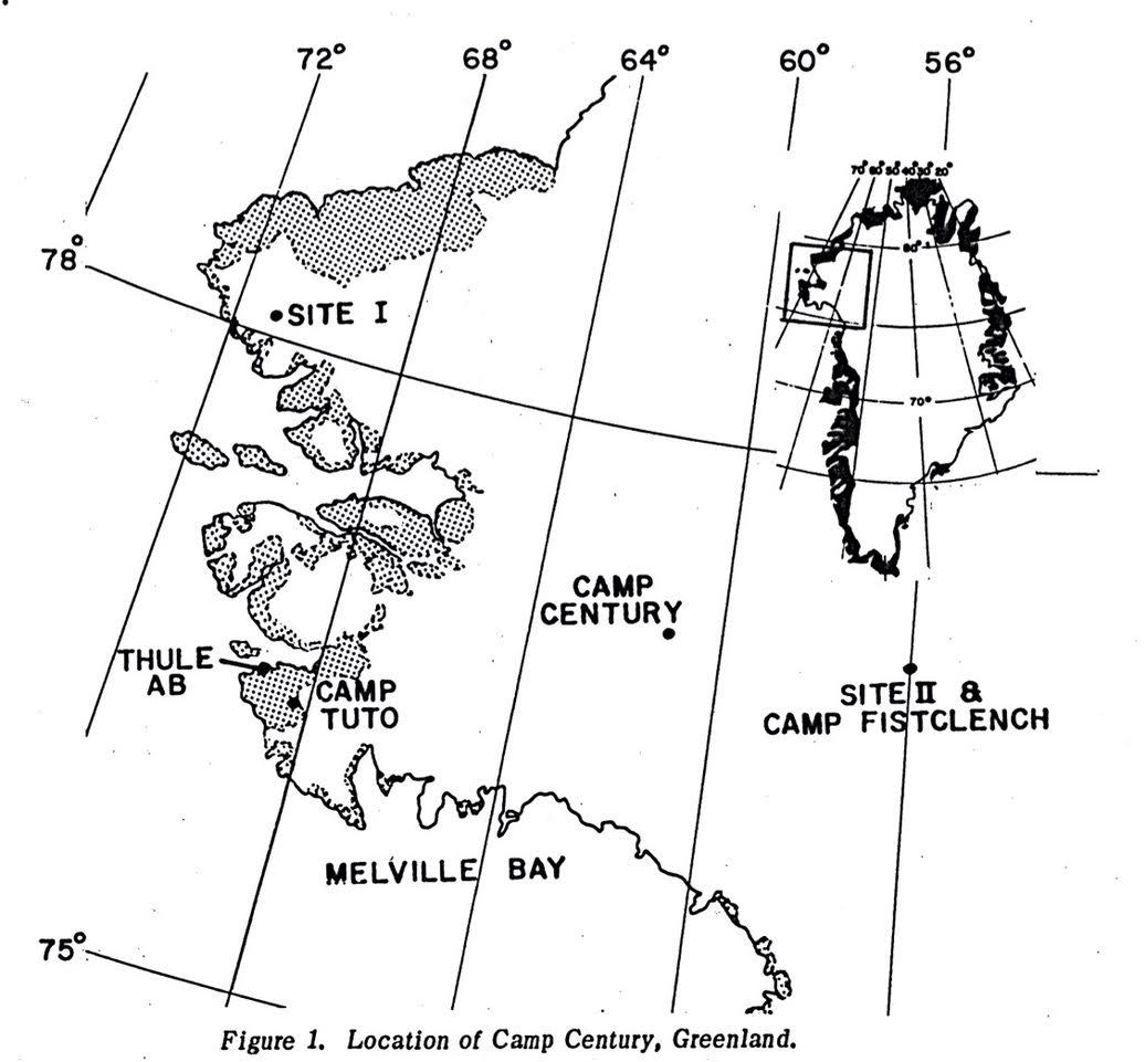
Location map showing the location of Camp Century, Site I, and Site II. [Credits: CRREL Special Report 150]
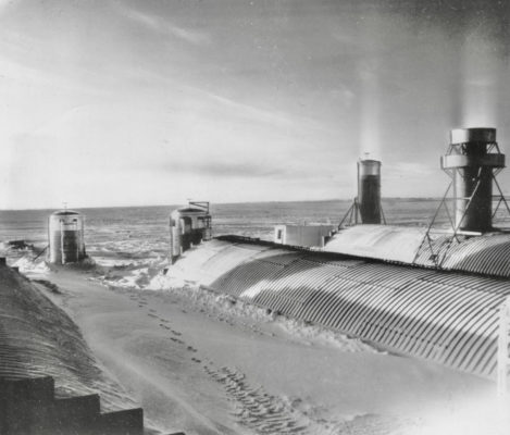
It’s October 1953 in northwest Greenland. Sixteen American servicemen are living inside the Greenland Ice Sheet, 200 kilometers north of Thule Airbase and about 1300 km from the north pole. Their housing was unique. They were living in a base made of corrugated steel tubes 30 meters long and 5.4 meters wide. Inside those tubes were insulated buildings, bunk rooms, a mess hall, and a recreation room along with a communication center and diesel generators (Mellor, 1964). This was Site I, which had several aliases: N-33, G-33, A-Site, Etah Station (Buss, L., 1957). Site I had a twin, Site II, which was located 385 km to the southeast, closer to the center of the ice sheet. Supplies came by airdrop and airplane to Site I.
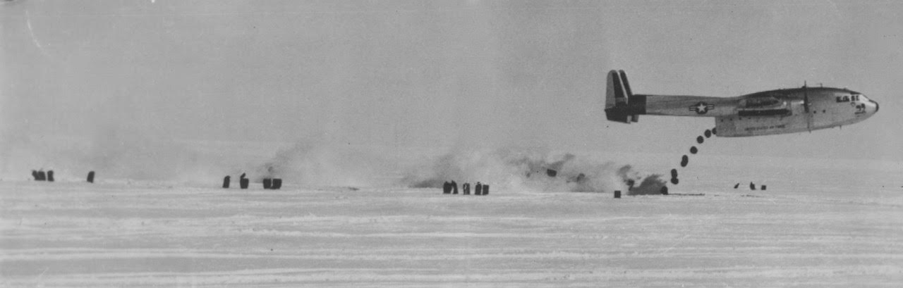
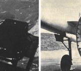
Supplies air dropped to Site I or Site II by a C-119, the flying boxcar, a workhorse cargo plane. [Credits: U.S. Air Force]
Camp Century, the U.S. military base built under the ice in 1959 and 1960 on the Greenland ice sheet, is certainly far more famous, but Sites I and II were the first large-scale American experiment in heated in-ice living. Both camps were secret but the public knew all about them, sort of. In 1954, photographs of the stations ran in newspapers across America in articles with titles like, The Army Gets a Mole Type of Arctic Tent, in the Austin American on December 21, 1954.
Sites I and II were touted as proud Army and Air Force weather stations on the ice cap. The locations were secret, just like the real purpose of the tubes and the men in them. Yes, the men did collect weather data but that was only part of the story. These were first and foremost radar stations on watch for Soviet missiles and bombers, 24/7. Their purpose was to fill the gap between the larger, more powerful radar stations of the Northeast Air Command. This was an early 1950s collaborative venture between the United States and Canada. By 1954, more than 20 radar stations scanned the arctic skies for a Soviet threat.

Air Force men moving cargo inside one of the 5.4 meter tubes. [Credits: U.S. Air Force]
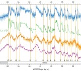
The camps and their tubes were built to be buried but the military didn’t know how well burial would work. So, they instrumented the stations with survey points and pressure transducers (Hansen, 1955). The warm stations melted some of the snow around the transducers making pressure measurements unreliable. But the survey points proved useful. Over a dozen years, engineers returned to the tubes at Site II and measured as their circular cross-sections, under the pressure of deepening snow above, slowly and steadily became ovals (Mellor, 1964). By 1965, a typical 5.4 meter tube was 82 cm shorter and 37 cm wider. Where a sewage pipe had leaked at Site II, spilling warm liquid into the firn below one of the tubes, the tube was tilting badly, reflecting the melt-induced collapse beneath.

The tubes slowly and steadily deformed over the decade they were monitored by the U.S. Army Corps of Engineers. These are data from 5.4 m diameter tubes measured between 1953 and 1963. Figures from Mellor (1964).
The Stations are Abandoned
The need for gap-filling radar quickly faded and, within a few years, Sites I and II were abandoned (Buss, 1957). The U.S. military knew that both stations were in the accumulation zone, where the amount of deposited snow exceeds the amount that is lost with melting. The snow line (the elevation above which the last winter’s snow does now fully melt in the following summer) in northwest Greenland in the 1950s was poorly known and reported as between sea level and about 900 meters elevation (Diamond, 1960). Site I sat at about 1200 meters elevation and about 15 km from the ice margin and the coast. Site II was much higher (2130 m) and more than 250 km further inland.
There’s no indication anything was removed from either Site I or II when they were abandoned. Left behind at each site were 2200 tons of metal, diesel generators, lead paint, fuel, caulking likely laced with PCBs, as well as three years of frozen sewage that had melted its way into the ice cap. The assumption was that all of this was buried in an icy grave, if not forever, then for long enough that no one would know, remember, or care when it melted out. That turned out to be a poor assumption.
William Colgan caught the public’s attention when he found Camp Century, the most famous U.S. military base built under the snows of the Greenland ice sheet. This base (look at this video if you want to know more) was a maze of tunnels occupied between 1960 and 1966 by up to 200 men. It was the site of the first deep ice core, drilled to the base of the ice sheet by a team from the U.S. Army Corps of Engineers and funded in part by the U.S. National Science Foundation. Next week’s post will go into much more detail about what’s been learned from this core about Greenland’s climate and glacial history.
Today, it lies below tens of meters of snow and ice (Colgan et al., 2016). Using ice penetrating radar, he identified the camp and clearly imaged the large, deep waste sumps full of sewage and glycol. His initial conclusion was that as the climate warmed and the ablation zone spread upward and inland, Camp Century would eventually daylight, perhaps as soon as 2100. Later work suggested such a rapid melt out was unlikely. Camp Century is more than 200 kilometers away from the margin of the ice sheet and sits at almost 1900 meters elevation. Site I is 700 meters lower and only 15 kilometers from the edge of the ice sheet and the coast. Its melt out will provide a dry run for its bigger, younger cousin, Camp Century.
It’s hard to know how deeply buried the top of Site I is today but we can take an educated guess. At Thule, 200 km south and at sea level, about 200 mm of precipitation (water equivalent) falls yearly. Presuming that much precipitation fell as snow at Site I since 1953 and none melted, that’s 69 years of accumulation, about 13.8 meters of water equivalent. If the density of firn above the tubes now averages 0.5 t/m3, the camp would be buried 28 meters. Alternatively, consider the data from Mellor’s 1964 report, which indicate that the 5.4 meter tubes were covered by 6 meters of snow in 1962 (that’s 9 years of accumulation). Sixty more years of accumulation would then give a total of 37 meters of snow using the density/depth curve of Mellor (1964) implying 266 mm of water equivalent deposited annually although the surface roughness provided by the camp buildings may have encouraged deposition initially. In either case, Site I might be under about as much snow and ice as Camp Century (Colgan et al., 2016). We and others have looked at the IceBridge radar data (a project that uses plane-based radar to probe the ice sheet’s internal structure) and have yet to find traces of Site I beneath Greenland’s snowy surface.
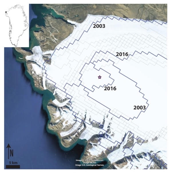
Google Earth image overlain with CryoClim snowline estimates and the location of Site I (purple star). Bold lines are the 2003 and 2016 snowlines. In 2003, local melt occurred in the area surrounding Site I, but below that elevation, some snow remained over summer. Inset shows Greenland with a box indicating the area of the larger image.
What’s next?
As the climate has warmed, the snowline has crept closer to Site 1. Based on remote sensing data, since 2001 Site 1 has been below the snow line at the end of two summers, 2003 and 2016. That means no net accumulation and the loss of some snow and ice that once covered the site. For the period 2001 to 2021, satellite-based snowline data (from the CryoClim project) indicates that the median snowline elevation is about 800 m around Site I.
Since it was built, Site I has been slowly moving lower and toward the coast with the ice that contains it. Ice velocity estimates from 1995 to 2015 (Joughin et al., 2017) suggest that Site I is moving west southwest at 8.5 meters per year. If this is the long-term average movement rate, then the metal tubes are almost 600 m closer to the coast and 10 m lower than when the camp was built. With the climate steadily warming and the Greenland Ice Sheet as a whole losing mass, it’s only a matter of time before the ablation zone comes to Site I. It’s the oldest, lowest, and closest to the ice margin of several 1950s U.S. military camps buried in the Greenland Ice Sheet. Even before the camp daylights, meltwater flowing through the firn will carry contaminants toward the coast and Baffin Bay.
Hindsight is 20/20. When these camps were installed in the 1950s, the highest priority was defense, not the environment. There was little thought that the camps and their waste would ever daylight. Just as tons of waste from decades of expeditions are now being removed from Mount Everest, cleanup of these military camps should be in our collective future. We can hope that our current understanding of ice dynamics, climate change, and the environmental impacts of depositing waste in the otherwise pristine arctic means that in the future we will not be so cavalier about what we leave behind. The bright side is that these abandoned camps, a time capsule from the 1950s and 1960s, provide insights into ice and material dynamics over more than half a century.
Acknowledgement
This work has been supported by the U.S. National Science Foundation under grant EAR- 2114629, A fossil ecosystem under the ice: deciphering the glacial and vegetation history of northwest Greenland using long-lost Camp Century basal sediment. Thanks to D. Dethier, T. Neumann, and W. Colgan for reading versions of this post and offering suggestions for improvement.
Further Reading
- Colgan et al. (2016) The abandoned ice sheet base at Camp Century, Greenland, in a warming climate. Geophys. Res. Lett. 43: 8091–8096, DOI: 10.1002/2016GL069688.
- Mellor (1964) Undersnow structures: N-34 radar station, Greenland. CRREL Technical Report 132.
- Mellor (1968), Methods of building on permanent snowfields. Cold Regions Research and Engineering Laboratory (U.S.), Monograph III-A2a.
Edited by Giovanni Baccolo
 Paul Bierman is a Professor of Natural Resources at the University of Vermont where he studies paleoclimate with a focus on the coming and going of Greenland’s Ice Sheet. He directs the NSF/UVM Community Cosmogenic Facility and is author of two geology textbooks. Bierman is currently completing a general audience book on the history of Camp Century, based on his recent work with Andrew Christ and an international team of collaborators on the basal sediment of the ice core collected there between 1960 and 1966.
 Amanda Schmidt is an Associate Professor of Geology at Oberlin College where she studies human-landscape interactions. She and her undergraduate research students run a gamma counting lab where they analyze short-lived fallout radionuclides. Amanda has expertise in spatial data analysis and the effect of landscape change on mass fluxes in tropical, developing nations.
Irene Quaile
Thanks for this! Very informative. I’m glad to have discovered the blog and will lookin more often.
Irene Quaile
http://Www.iceblog.org
Sophie Berger
You are welcome Irene!