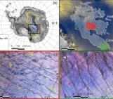
Figure 1: The Moderate Resolution Imaging Spectroradiometer (MODIS) on NASA’s Terra satellite acquired these images of the Maud Rise or Weddell polynya in the eastern Weddell Sea on September 25, 2017. The first image is natural color and the second is false color where areas of ice are in blue and clouds are in white. [Image credit: NASA Earth Observatory].
The mysterious appearance and disappearance of the Weddell Polynya, a giant hole in the ice, has long puzzled scientists. Recent work reveals that it is tightly tied to energetic storms. Read on to find out more…
The eastern side of the Weddell Sea is a region known for its low concentration of sea ice due to the presence of a seamount, an underwater plateau called the Maud Rise. The seamount influences ocean circulation by bringing warm water closer to the surface, preventing the formation of thick ice. In the early 1970s, when satellites first began snapping photos of Earth, scientists noticed a mysterious hole in Antarctica’s seasonal sea ice floating in this area. This phenomenon is known as a polynya, and for decades its occurrence went unexplained. Then in 2017, during the continent’s coldest winter months, when ice should be at its thickest, a giant 9,500-square-kilometre hole suddenly showed up in the same region (Figure 1). Two months later it had grown 740% larger, before merging with the open ocean at the beginning of the melt season.
The Weddell Polynya is a rather famous hole in the ice (see this previous post). Scientists have been investigating such features in the Southern Ocean for decades, but the true reasons for the appearance and disappearance of the Weddell Polynya were still surrounded by mystery – until now.
Why does the Weddell Polynya form?
Recently, our new study found that these mid-sea polynyas can be triggered by strong cyclonic storms. Using satellite observations and reanalysis data, we found that in some winters, atmospheric circulation moves a significant amount of heat and moisture from mid-latitudes to Antarctica, allowing large cyclones to develop over the sea ice pack. When strong cyclones – some as strong as hurricanes – form and spin over the ice pack, the strong cyclonic winds they can drag the floating sea ice in opposite directions away from the cyclone center, creating the opening.
Sea ice typically drifts in a direction turned 30° on average to the left of the atmospheric flow, with a speed amounting to 1–2% of the surface wind speed. Those rules, when applied to a cyclonic wind situation (i.e., two opposing winds around a center), imply divergence in the motion of sea ice leading to open water area within the cyclone center, as in Fig. 2. We can see how such a situation occurs in real life for the Weddell Polynya when looking at Fig. 3, where near-surface winds exceeding 20 m/s are pushing the ice in opposite directions away from the cyclone center, characterized by weak winds, and the hole in the ice underneath it.
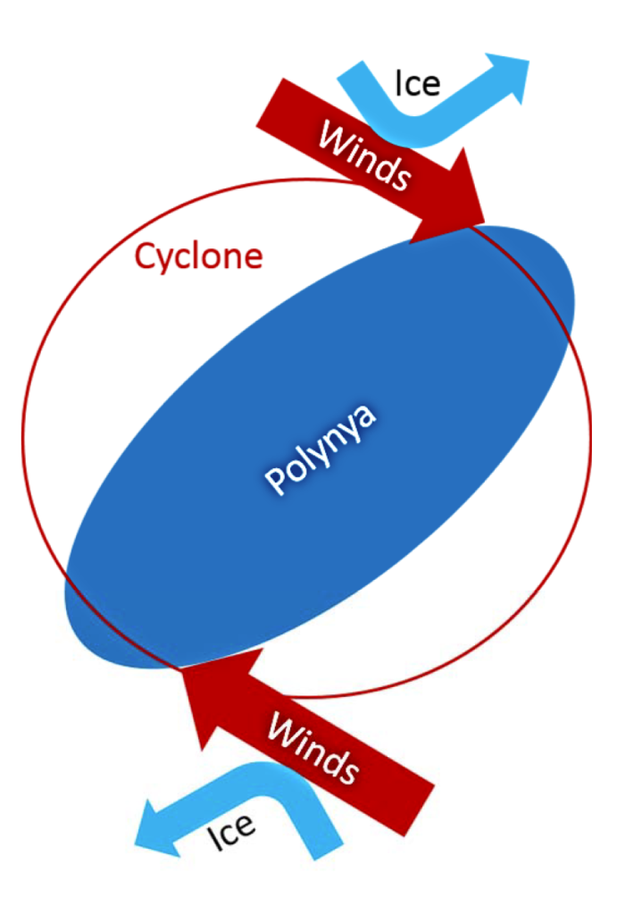
Figure 2: Sketch summarizing the mechanisms by which the cyclone can open the polynya [Credit: Francis et al., 2019].
Why does the Weddell Polynya matter?
Once opened, the polynya works like a window through the sea ice, transferring huge amounts of energy during winter between the ocean and the atmosphere. Because of their large size, mid-sea polynyas are capable of impacting the climate regionally and globally. This includes impact on the regional atmospheric circulation, the global overturning circulation, Antarctic deep and bottom water properties, and oceanic carbon uptake. It is important for us to identify the triggers for their occurrence to improve their representation in models and their effects on climate.
What might happen in the future?
Under future warming-climate conditions, previous studies have predicted an intensification of the activity of polar cyclones and a poleward shift of the extratropical storm track. Others have shown that a poleward shift of the cyclone activity can result in a reduced sea ice extent, a situation similar to that observed in 2016 and 2017. When the sea ice extent is reduced, preferable polynya areas (i.e. areas of thinner ice, for example the Maud Rise) located in the ice pack become closer to the ice edge and hence to the cyclogenesis zone. Given the link between polynya occurrence and cyclones, polynya events may thus become more frequent under a warmer climate.
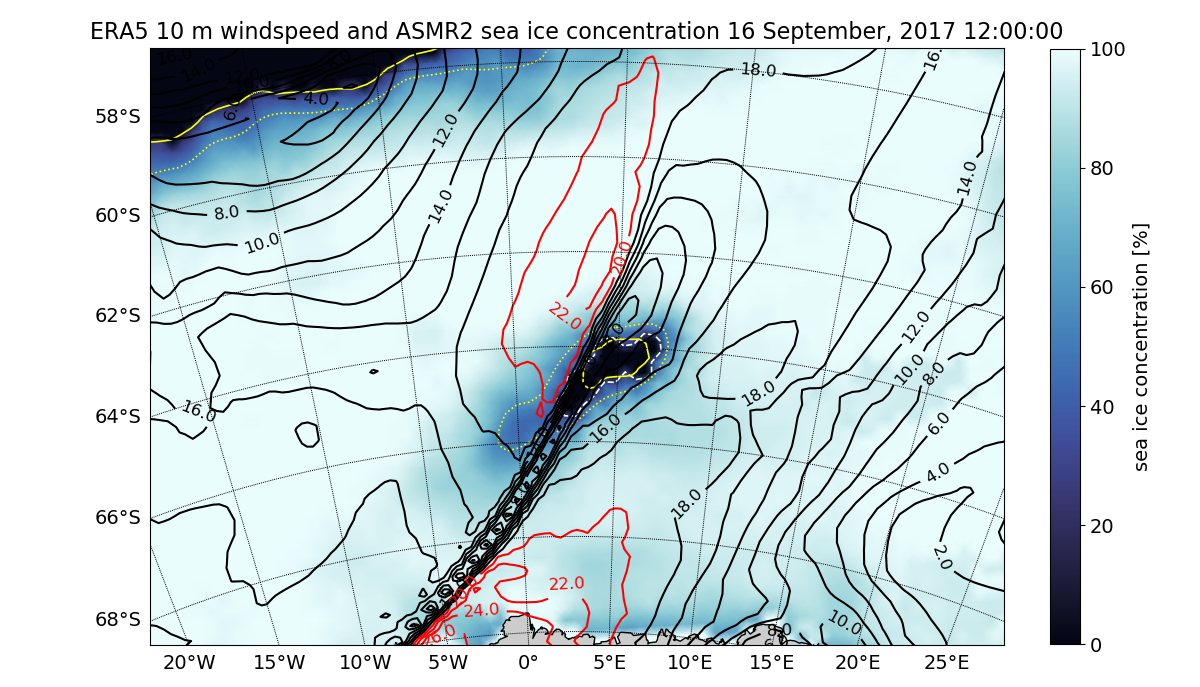
Figure 3 AMSR2‐derived sea ice concentrations on 16 September 2017 at 1200 UTC (colors) and ERA5 10‐m winds less than 20 m/s in black contours, and greater than 20 m/s in red contours.The solid yellow contour is the 15% ERA‐Interim sea ice contour, the dotted yellow contour is the 50% ERA‐Interim sea ice contour, and the dashed white contour is the 15% ice from satellite data delineating the polynya area. [Credit: Francis et al., 2019].
Further reading
- Francis et al. (2019b), Polar cyclones at the origin of the reoccurence of the Maud Rise Polynya in austral winter 2017, Journal of Geophysical Research: Atmospheres, 124. https://doi.org/10.1029/2019JD030618.
- Jena et al. (2019), Recent Reoccurrence of Large Open‐Ocean Polynya on the Maud Rise Seamount, , Geophysical Research Letters, https://doi.org/10.1029/2018GL081482.
- Bailey et al. (2004), Relationship between synoptic forcing and polynya formation in the Cosmonaut Sea: II. Regional climate model simulations, Journal of Geophysical Research, 536 doi:10.1029/2003JC001838
- Image of the Week – A Hole-y Occurrence, the reappearance of the Weddell Polynya
Edited by Lettie Roach
 Diana Francis is an atmospheric scientist at New York University Abu Dhabi, UAE. She investigates atmospheric dynamics in polar regions with focus on polar meteorology and links to changes in land and sea ice conditions. To this end, she uses regional models together with available observations and reanalyses. She tweets as @drdianafrancis.
Contact Email: diana.francis@nyu.edu

