Current position: 89°31.85 N, 62°0.45 E, drifting with a multi-year ice floe (24th August 2018)
With a little more than three weeks into the Arctic Ocean 2018 Expedition, the team has found the right ice floe and settled down to routine operations.
Finding the perfect ice floe for an interdisciplinary science cruise is not an easy task. The Arctic Ocean 2018 Expedition aims to understand the linkages between the sea, microbial life, the chemical composition of the lower atmosphere and clouds (see previous blog entry) in the high Arctic. This means that the “perfect floe” needs to serve a multitude of scientific activities that involve sampling from open water, drilling ice cores, setting up a meteorological tower, installing balloons, driving a remotely operated vehicle, measuring fluxes from open leads and sampling air uncontaminated from the expedition activities. The floe hence needs to be composed of multi-year ice, be thick enough to carry all installations but not too thick to allow for drilling through it. There should also be an open lead large enough for floating platforms and the shape of the floe needs to be such that the icebreaker can be moored against it on the port or starboard side facing all for cardinal directions depending on where the wind is coming from.
The search for the ice floe actually turned out to be more challenging than expected. The tricky task was not only to find a floe that would satisfy all scientific needs, but getting to it north of 89°N proved exceptionally difficult this year. After passing the marginal ice zone north of Svalbard, see blue line on the track (Figure 2), progress through the first year ice was relatively easy. Advancing with roughly 6 knots, that is about 12 km/h, we advanced quickly. After a couple of days however, the ice became unexpectedly thick with up to three meters. This made progress difficult and slow, even for Oden with her 24,500 horse powers. In such conditions the strategy is to send a helicopter ahead to scout for a convenient route through cracks and thinner ice. However, persistent fog kept the pilot from taking off which meant for the expedition to sit and wait in the same spot. For us aerosol scientists looking at aerosol-cloud interactions this was a welcome occasion to get hand on the first exciting data. In the meantime, strong winds from the east pushed the pack ice together even harder, producing ridges that are hard to overcome with the ship. But with a bit of patience and improved weather conditions, we progressed northwards keeping our eyes open for the floe.
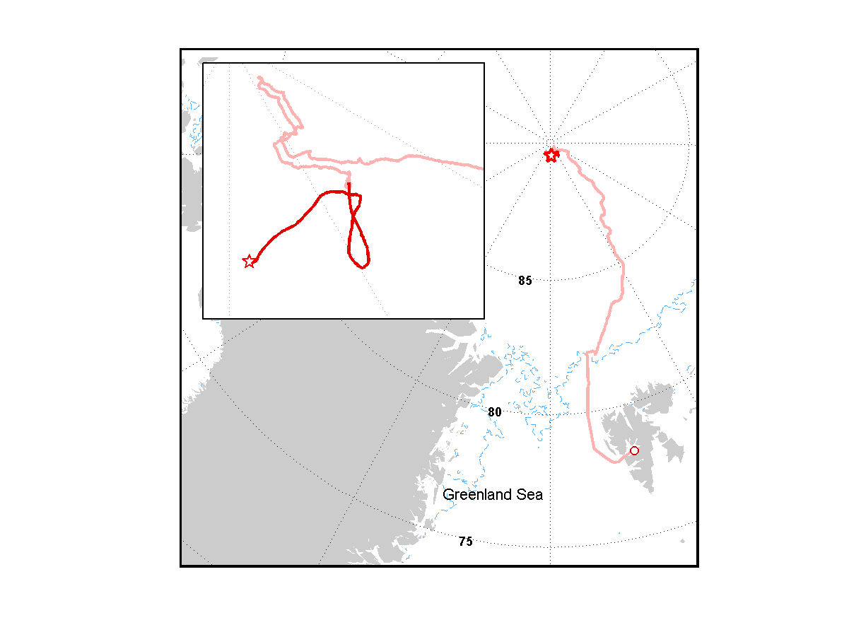
Figure 2: Cruise track with drift. The light red line indicates the track to the ice floe, the dark red line indicates the drift with the floe. The thin blue line is the marginal ice zone from the beginning of August.
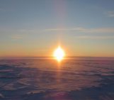
As it happened, we met unsurmountable ice conditions at 89°54’ N, 38°32’ E, just about 12 km from the North Pole – reason enough to celebrate the farthest North.

Figure 3: Expedition picture at the North Pole. (Credit: SPRS)
Going back South from there it just took a bit more than a day with helicopter flights and good visibility until we finally found ice conditions featuring multiple floes.
And here we are. After a week of intense mobilization on the floe, the four sites on the ice and the instrumentation on the ship are now in full operation and routine, if you stretch the meaning of the term a bit, has taken over. A normal day looks approximately like this:
7:45: breakfast, meteorological briefing, information about plan of the day; 8:30 – 9:00: heavy lifting of material from the ship to the ice floe with the crane; 9:00 (or later): weather permitting, teams go to the their sites, CTDs are casted from the ship if the aft is not covered by ice; 11:45: lunch for all on board and pick-nick on the floe; 17:30: end of day activities on the ice, lifting of the gangway to prevent polar bear visits on the ship; 17:45: dinner; evening: science meetings, data crunching, lab work or recreation.

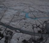
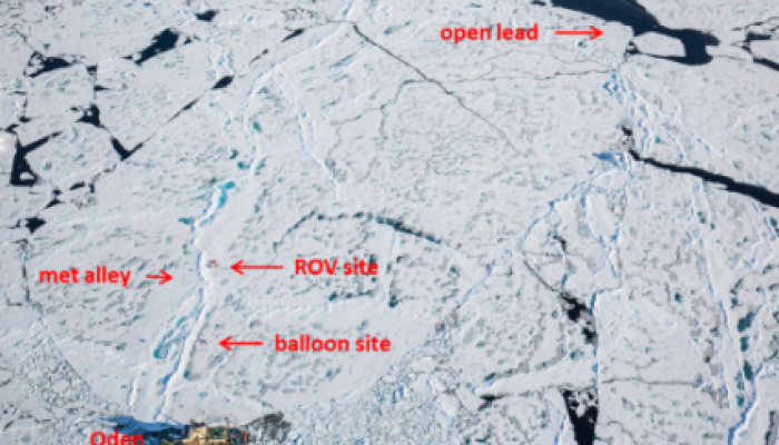
Figure 4: Sites on the floe, nearby the ship. (Credit: Mario Hoppmann)
At the balloon site, about 200 m from the ship, one balloon and one heli-kite are lifted alternately to take profiles of radiation, basic meteorological variables and aerosol concentrations. Other instruments are lifted up to sit over hours in and above clouds to sample cloud water and ice nucleating particles, respectively. At the met alley, a 15 m tall mast carries radiation and flux instrumentation to characterize heat fluxes in the boundary layer. The red tent at the remotely operated vehicle (ROV) site houses a pool through which the ROV dives under the flow to measure physical properties of the water. The longest walk, about 20 minutes, is to the open lead site, where a catamaran takes sea surface micro layer samples, a floating platform observes aerosol production and cameras image underwater bubbles. The ice core drilling team visits different sites on the floe to take samples for microbial and halogen analyses.
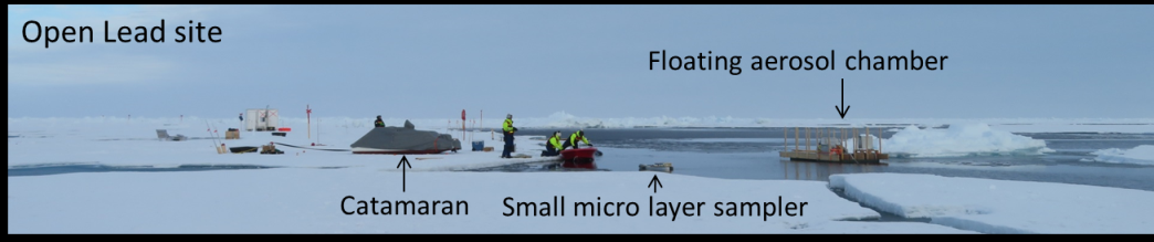
Open Lead site. (Credit: Julia Schmale)
Importantly, all activities on the ice need to be accompanied by bear guards. Everybody carries a radio and needs to report when they go off the ship and come back. If the visibility decreases, all need to come in for safety reasons. Lab work and continuous measurements on the ship happen throughout the day and night. More details on the ship-based aerosol laboratory follow in the next contribution.
Edited by Dasaraden Mauree
 Julia Schmale is an atmospheric scientist at the Paul Scherrer Institute in Switzerland. Her research focuses on aerosol-cloud interactions in extreme environments. She is a member of the Atmosphere Working Group of the International Arctic Science Committee and a member of the Arctic Monitoring and Assessment Programme Expert Group on Short-lived Climate Forcers .