The Dead Sea is one of the saltiest lakes on Earth, located at the lowest point of the globe. For centuries it has been known for the restorative powers of its muds and waters. Their hypersalinity means it is possible to easily float on the lake’s surface.
Bordering Israel, the West Bank and Jordan, it is a unique environment in an otherwise arid region. Changing climate, which is seeing temperatures rise in the Middle East, and the increased demand for water in the region (for irrigation) mean the areas on the banks of the lake are suffering a major water shortage. As a result, the lake is shrinking at an alarming rate.
The changing geomorphology of the Dead Sea region is now the focus of a large international project (DESERVE) to address the resulting geohazards at the Dead Sea.
One of the consequences of the rapid fall of the water level (>1 m per year), is that vast areas of salt-rich ground of the shrunken Dead Sea are prone to strong dissolution and mechanical erosion of the subsurface processes. This leads to the widespread land subsidence and the development of sinkholes, which pose a major geological hazard to infrastructure, local population, agriculture and industry in the Dead Sea area, writes Djamil Al-Halbouni in an abstract presented at the EGU 2016 General Assembly.
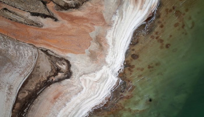
Today’s Imaggeo on Monday’s image was taken in the purpose of investigating the sinkhole phenomenon along the coastline.
“Near-surface aerial photography offer valuable hints on possible processes that lead to the formation of huge depression zones, e.g. the ground and surface water flow, the existence of vegetation and water sources or simply the morphology,” explains Djamil.
Sets of images are then combined into digital terrain models to quantitatively estimate hazard potentials and development of sinkholes via repeated measurements.
Specifically, this image was taken by a camera on a helikite balloon from 150m altitude. It shows a canyon penetrating the whitish pure salt shoreline at the Jordanian coast. It also reveals, in its’ magnitude surprising for the scientists involved, round structures under the shallow water, which are interpreted as submarine springs and possible submarine sinkholes close to the shore.
By Laura Roberts and Djamil Al-Halbouni of the German Research Center for Geosciences, Physics of the Earth, Potsdam, German
Imaggeo is the EGU’s online open access geosciences image repository. All geoscientists (and others) can submit their photographs and videos to this repository and, since it is open access, these images can be used for free by scientists for their presentations or publications, by educators and the general public, and some images can even be used freely for commercial purposes. Photographers also retain full rights of use, as Imaggeo images are licensed and distributed by the EGU under a Creative Commons licence. Submit your photos at http://imaggeo.egu.eu/upload/.