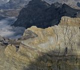
The Gulf of Corinth, in southern Greece, separates the Peloponnese peninsula from the continental mainland. The structural geology of the region is complex, largely defined by the subduction of the African Plate below the Eurasian Plate (a little to the south).
The Gulf itself is an active extensional marine basin, i.e., one that is pulling open and where sediments accumulate. Sedimentary basins result from the thinning, and therefore sinking, of the underlying crust (though other factors can also come into play). The rifting in the region is relatively new, dating back some five million years, and results in rare but dangerous earthquakes.
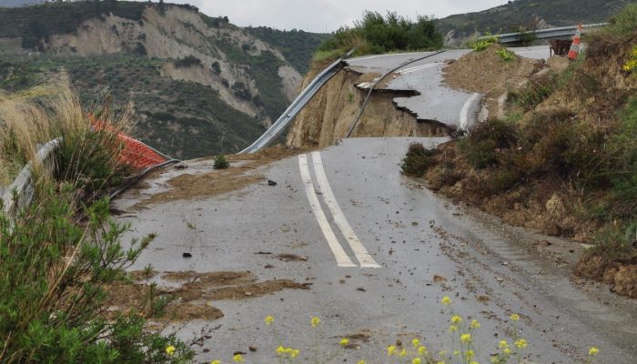
The active tectonics result in a plethora of other natural hazards, not only earthquakes. Minor and major faults crisscross the area and have the potential to trigger landslides, posing a threat to lives and infrastructure. A road, swept away in a landslide, in the northern Peloponnese (along the southern margin of the Corinth rift) is a clear example of the hazard.
“This photo was taken in the Valimi fault block [editor’s note: a section of bedrock bound on either side by faults], east of the Krathis valley. West of this valley, the landscape is characterised by narrow and deep gorges as the present day rivers cut into the well-consolidated conglomerates deposited during the active extension of the basin,” explains Romain Hemelsdaël, author of this week’s imaggeo on Mondays photograph.
Characteristically, sediments deposited in actively extensional rifts where the Earth’s crust and lithosphere are being pulled apart, as at the Gulf of Corinth, change in size (both horizontally and vertically) and composition. To the east of the Krathis valley, the sediments are being uplifted and are dominated by less competent sandstones and siltstones, as opposed to the conglomerates found in the Valimi fault block.
“The present landscape along this part of the rift margin forms large valleys covered by active landslides,” clarifies Romain. “In this photograph, the road was initially constructed directly on silts which were deposited by lakes and rivers. Up the hill, a temporary track currently replaces the road but this track still remains within an active landslide.”
Imaggeo is the EGU’s online open access geosciences image repository. All geoscientists (and others) can submit their photographs and videos to this repository and, since it is open access, these images can be used for free by scientists for their presentations or publications, by educators and the general public, and some images can even be used freely for commercial purposes. Photographers also retain full rights of use, as Imaggeo images are licensed and distributed by the EGU under a Creative Commons licence. Submit your photos at http://imaggeo.egu.eu/upload/