EGU Blogs

499 search results for "Imaggeo on Mondays"

GeoLog

Imaggeo on Mondays: Civita di Bagnoregio – the dying town

Imaggeo on Mondays: Civita di Bagnoregio – the dying town

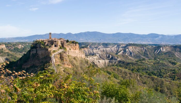
On top of a steep cliff standing out from the surrounding countryside, lies the small town of Civita di Bagnoregio, one of the most famous villages of Italy. It is often called the dying town, although more recently people have started to refer to it as fighting to live. What this little town is fighting against is the threat of erosion, as its walls are slowly crumbling down. Located in central I ...[Read More]

GeoLog

Imaggeo on Mondays: Rocks weather, soil takes form

Imaggeo on Mondays: Rocks weather, soil takes form

This image depicts the soil formation, that is weathering of rock. Soil is actually formed by weathering of rock by physical, chemical and biological methods. This image depicts physical and biological weathering. Physical weathering by the action of temperature and biological weathering by the growth of some species of grass through the cracks. Image clicked from Trivandrum district of Kerala, In ...[Read More]

GeoLog

Imaggeo on Mondays: Subsurface meteorolgy in Iceland

Imaggeo on Mondays: Subsurface meteorolgy in Iceland

With a total length of about 2 km, the Surdsellir lava cave is part of the Hallmundarhraun lava field in western Iceland. The caves ceiling is partly broken in, forming entrances and windows towards the earths surface. On this day of typically Icelandic weather, meteorological conditions changed quickly between sun, clouds, rain and wind. While walking through the cave during a rain shower, the su ...[Read More]

GeoLog

Imaggeo on Mondays: The glacier surviving climate change

Imaggeo on Mondays: The glacier surviving climate change

Human impacts on the climate are nowadays clearly discernible, and the changes to our climate that previously happened in geologic time scales are currently happening during the span of a human lifetime. Our planet is warming and temperature today is now more than 1°C higher than it was in the pre-industrial world and rises by about 0.15-0.2°C on average each decade. The dramatic effects of this r ...[Read More]

GeoLog

Imaggeo on Mondays: A walk at the glacier

Imaggeo on Mondays: A walk at the glacier

In 2012 I had the opportunity to help lead a teaching excursion to the Norwegian archipelago Svalbard. On this trip, geography students from the Ruhr-University of Bochum in Germany had the chance to learn more about the nature of this fascinating island. In addition to Svalbard’s climatology and the wildlife, the region’s glaciology and geomorphology were the main topics we focused on. For exampl ...[Read More]

GeoLog

Imaggeo on Mondays: An expedition to better understand Antarctic soils

Imaggeo on Mondays: An expedition to better understand Antarctic soils

A dramatic evening sky puts the frame to a photo taken during the Brazilian Antarctic expedition to James Ross Island in 2016. Brazilian palaeontologists and soil scientists together with German soil scientists spent over 40 days on the island to search for fossils and sample soils at various locations of the northern part of the island. The island was named after Sir James Clark Ross who led the ...[Read More]

GeoLog

Imaggeo on Mondays: The colourful sinkhole clusters at Ghor Al-Haditha

Imaggeo on Mondays: The colourful sinkhole clusters at Ghor Al-Haditha

Sinkholes that form on the Dead Sea shore at Ghor Al-Haditha, Jordan, often occur in clusters, with many holes packed into a small area. However the visual appearance of neighbouring sinkholes can vary significantly. Mineral precipitation in the foremost sinkhole in this picture, which has no fresh water supply, gives it a garish pink-orange colouration. The larger hole behind has a groundwater-de ...[Read More]

GeoLog

Imaggeo on Mondays: The polje between sky and Earth

Imaggeo on Mondays: The polje between sky and Earth

Poljes are one of the most impressive features existing in karst landscapes. These large flat closed depressions are prone to regular flooding that can form temporary lakes on their surface. Planinsko Polje [in Slovenia] is surely the most famous example of polje existing. The highest floods can reach up to 8 metres above the gauging station and last for more than two months. The lake is then more ...[Read More]

GeoLog

Imaggeo on Mondays: How do Earth’s Northern Lights form?

Imaggeo on Mondays: How do Earth’s Northern Lights form?

Aurora Borealis, which means Northern Lights are caused by electrically charged particles from the sun, which enter the Earth’s atmosphere and collide with gases such as oxygen and nitrogen. When the charged particles are blown towards the Earth by the solar wind, they are largely deflected by the Earth’s magnetic field. However, the Earth’s magnetic field is weaker at the poles and therefore some ...[Read More]

GeoLog

Imaggeo on Mondays: A lifeline between light and shadow

Imaggeo on Mondays: A lifeline between light and shadow

The Rapaälven making its way through the Rapadalen valley in Northern Sweden. After over a week of hiking through pure wilderness I reached the summit of Skierffe together with three friends. We were just blown away by the view and completely in awe for the beautiful shape of the rivers course… little lakes in between river channels of different sizes as well as dense vegetation forming a ha ...[Read More]