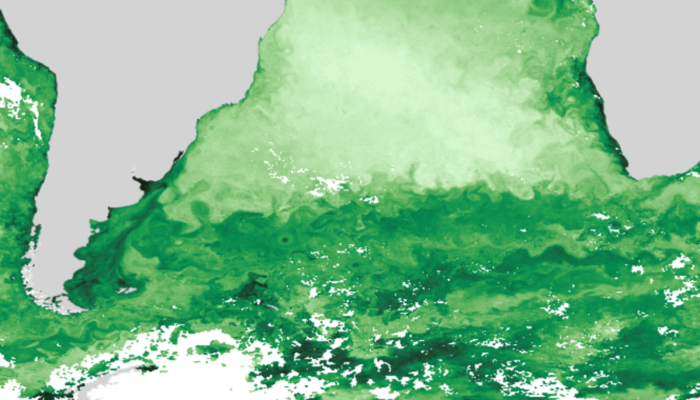
Subduction zones are dynamic regions where intense geological processes like earthquakes, volcanic eruptions, and the recycling of oceanic crust are constantly at play. A key factor that influences the behavior of these zones is *interface rheology*—the strength and viscosity of the boundary (the interface) between the subducting and overriding plates. Understanding this interface is crucial for i ...[Read More]
If you didn't find what you was looking for try searching again.
GeoLog
Hera: A journey to Mars kicks off Earth’s latest defence plan
And what if we could prevent a catastrophe as old as the dinosaurs?… As Hera’s mission launched last month, this blog post aims to give you insights into this mission and why it matters. Continue reading and find out! One of humans’ biggest rebellious acts against insignificance is staring at the sky and wondering what else is out there, then thinking “We can definitely fin ...[Read More]
GeoLog
From ‘real life’ to a fantastic quirky teaching tool – try a PodCast Class
A giant microphone sits a few cm’s from my face. I am having vivid flashbacks to pre-show jitters and stage-fright from my earlier forages into on stage productions. Only now I’m an adult, an expert, a scientist. Our host pushes the record button. Live radio! A brilliant (?) idea takes shape I was contacted by a Norwegian scientific radio programme, Abels Tårn, and asked if I could answer question ...[Read More]
GeoLog
Holding it in (the learning, not the pee) – The gendered importance of toilet breaks for geoscience students during field-courses
Field-based teaching is a cornerstone of geoscience education. Concepts such as scale, complexity, spatial awareness, 3D geometries, methods, skills, and techniques are inherently difficult to teach from a lecture theatre. However, achieving the benefits of field-based teaching might require a learning module not always considered as a prerequisite: planning and providing information about bathroo ...[Read More]
Cryospheric Sciences
Crossing borders – Glacier fieldwork at Sulitjelma/Salajekna
The time I first set foot at the university, I didn’t expect that two weeks later I would be looking at a backpack more than half my size, turning my back to the shelter of our rental car and walking almost 100 km in the Norwegian Arctic. Howling winds, heavy backpacks, daunting bridges, and endless beauty – that’s how I would describe my first experience with glacier fieldwork. I, Silje Waa ...[Read More]
Geodynamics
DYNAMICE: An ERC Starting grant project to bridge the gap between geodynamics and ice modelling
In the 2024 ERC Starting Grant call, the European Research Council received nearly 3,500 proposals, of which approximately 14% were awarded funding. Among the 20 projects funded in the field of Earth System Sciences is DYNAMICE, led by Ágnes Király, the 2023 recipient of the EGU GD Division Outstanding Early Career Award. Through this blog, Ágnes will introduce us to her project. The vast ice shee ...[Read More]
Stratigraphy, Sedimentology and Palaeontology
Drilling on world’s rooftop – the Nam Co-ICDP campaign on the Tibetan Plateau
International Scientific Continental Drilling Program (ICDP) campaigns may lead scientists from all over the world to most exciting places that are often of extraordinary beauty and remoteness. All these attributes certainly apply to Lake Nam Co situated at an altitude of 4700 m above sea level on the Tibetan Plateau in the Himalayas. Today this area supplies one third of the humankind with fresh ...[Read More]
Geomorphology
Highlights from Taiwan: Sampling environmental DNA (eDNA)
This blog post is part of our series: “Highlights” for which we’re accepting contributions! Please contact one of the GM blog editors, Emily (eb2043@cam.ac.uk) or Emma (elodes@asu.edu), if you’d like to contribute on this topic or others. by Caro Krug, Doctoral Student, ETH Zurich, Switzerland Email: cakrug@eaps.ethz.ch The Formosan landlocked salmon (Oncorhynchus masou formosanus) can only be fo ...[Read More]
GeoLog
Was that a meteor or a re-entry ? The final frontier for satellites when their mission ends
Like humans, satellites have a lifespan. These machines orbiting high above Earth serve various critical purposes that range from monitoring weather systems and tracking greenhouse gases to studying the cosmos. But even the most advanced satellites reach a point when their electronics wear out, their fuel depletes, and their missions come to an end. When their time is up, what becomes of these tir ...[Read More]
Hydrological Sciences
Mapping the Future of Freshwater: An Interview with Niko Wanders on the World Water Map Project
Back in 2022, two hydrologists and water resources specialists from University of Utrecht launched the World Water Map in collaboration with the National Geographic Society and ESRI. Based on the outputs of their global hydrological model PCR-GLOBWB, the team of Marc Bierkens and Niko Wanders map global water resources and identify the regions most at risk of water scarcity. The maps combine stat ...[Read More]