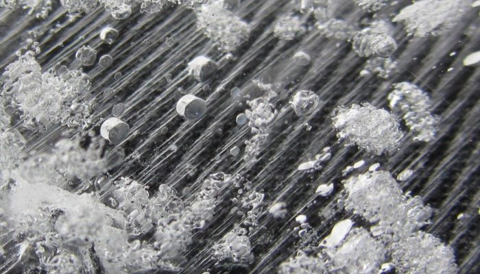
My friend John Jamieson, who is now a prof in the geology department at Memorial University in Newfoundland and Canada Research Chair in marine geology and is also a former GeoSphere guest poster is currently on a research cruise near Fiji. John researches deep sea vents, aka. black smokers/seafloor massive sulphide deposits that are exhaling super heated water at tectonic plate boundaries around ...[Read More]
If you didn't find what you was looking for try searching again.
GeoLog
Vlogging 101: A beginners guide to video blogging
Ensuring research outputs and findings have an impact in society is becoming an increasingly important part of successfully securing research funding. Perhaps even more importantly, some might argue that it is the responsibility of all geoscientists to communicate their science and research. Whatever your motivations for choosing to engage colleagues and non-scientific audiences with your research ...[Read More]
Geology Jenga
Lake mud can offer a crucial long-term perspective on flooding
The severe flooding that has hit much of northern England during the last few weeks (and northeastern Scotland right now) has generated significant discussion and debate about why floods happen, how often they occur and what we can do about it. The fact is there’s no simple answer to any of these questions: the hydrometeorological cycle is a complex beast and our actions have altered it in m ...[Read More]
GeoLog
The best of Imaggeo in 2015: in pictures
Last year we prepared a round-up blog post of our favourite Imaggeo pictures, including header images from across our social media channels and Immageo on Mondays blog posts of 2014. This year, we want YOU to pick the best Imaggeo pictures of 2015, so we compiled an album on our Facebook page, which you can still see here, and asked you to cast your votes and pick your top images of 2015. From the ...[Read More]
Biogeosciences
Insights into the ocean crust and deep biosphere – ECORD Summer School 2015
Summer time as an early career geochemist can mean many things, to some it is vacation time, to others it is field season, and yet for others it is time to enroll in a summer school. ECORD, the European Consortium for Ocean Drilling, offers at least one summer school a year. If you work with foraminifera you may be familiar with the Urbino Summer School in Paleoclimatology, sorry to disappoint, bu ...[Read More]
GeoLog
Imaggeo on Mondays: What a thin section has to say about the deformation of the Zagros Mountains
The impressive Zagros Orogeny, as seen from a bird’s-eye view, has featured on Imaggeo on Monday’s blog posts a few times recently. From its fluvial dissection features, through to a false colour LANDSAT 7 image which reveals a velociraptor hiding among fold and thrusts, we’ve looked at the broad scale structures which shape the Zagros mountains. This week, the scale changes entirely: we zoom righ ...[Read More]
GeoSphere
Guest Post: Jeremy Bennett – Approaches to modelling heterogeneity in sedimentary deposits
Hello everyone. Great that you could make it out to my blog post. I would like to introduce you to some ideas about environmental modelling that I have recently discovered during my work. These ideas are from this paper by Christine Koltermann and Steven Gorelick back in 1996. Whilst the primary focus of their paper is on modelling hydrogeological properties such as hydraulic conductivity, I think ...[Read More]
Soil System Sciences
Turning unproductive soil into profits
Preeti Roychand La Trobe University AgriBio Centre for AgriBioscience Melbourne, VIC, Australia Sandy soils in Western Australia are bad soils for growing plants due to their poor nutrients and water holding capacity (see an example in Figure 1). In general, these soils are water repellent, which leads to land degradation by increasing soil erosion risk and run-off rates. Nevertheless, these soils ...[Read More]
GeoLog
Imaggeo on Mondays: Velociraptor in the Zagros Mountains
How many times have you turned your head up to the sky and spotted familiar shapes in the clouds? Viewing structures from afar can reveal interesting, common and, sometimes, funny patterns. Satellite images are often used to map geological terrains. They offer a bird’s eye view of the planet and the opportunity to see broad scale structures, the scale of which would be impossible to grasp from the ...[Read More]
GeoLog
Imaggeo on Mondays: Sunset over the Labrador Sea
Ruby skies and calm waters are the backdrop for this week’s Imaggeo image – one of the ten finalist images in this year’s EGU Photo contest. “I took the picture while on a scientific cruise in West Greenland in 2013,” explains Christof Pearce, a postdoctoral researcher at Stockholm University. “We spent most of the time inside the fjord systems around the Greenland capital, Nuuk, but this specific ...[Read More]