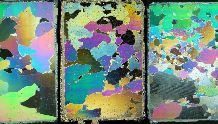
This week’s Imaggeo on Monday’s post, captured by Maksim Cherviakov, shows students from Saratov National Research University practicing a method to measure lake ice thickness. The students are using an ice auger to manually burrow through the ice. Afterwards, the ice depth is recorded using a tape measure. “We measure ice thickness every year on the lakes located in the floodplain of the Vo ...[Read More]
If you didn't find what you was looking for try searching again.
Cryospheric Sciences
Image of the Week — Allez Halley!
On the Brunt Ice Shelf, Antarctica, a never-observed-before migration has just begun. As the pale summer sun allows the slow ballet of the supply vessels to restart, men and machines alike must make the most of the short clement season. It is time. At last, the Halley VI research station is on the move! Halley, sixth of its name Since 1956, the British Antarctic Survey (BAS) has maintained a resea ...[Read More]
GeoLog
GeoTalk: Using satellites to unravel the secrets of our planet’s polar regions
Geotalk is a regular feature highlighting early career researchers and their work. In this interview we speak to Bert Wouters, a polar scientist at the University of Utrecht, and winner of one of the 2016 Arne Richter Awards for Outstanding Young Scientists. At a time when the polar regions are facing increasing challenges resulting from climate change, understanding how they might respond to them ...[Read More]
Cryospheric Sciences
Ice Cores “For Dummies”
Ice cores are important tools for investigating past climate as they are effectively a continuous record of snowfall, which preserves historical information about climate conditions and atmospheric gas composition. In this new “For Dummies” post, we discuss the history and importance of ice-core science, and look at the way we can use ice core chemistry to reconstruct past climate. Ice sheets, arc ...[Read More]
GeoLog
GeoPolicy: A new vehicle emissions test to be introduced, say EU’s top scientists
Last year the European Commission appointed a panel of world leading scientists to advise on key science policy issues. In November, the panel issued their first recommendation report focusing on CO2 vehicle emissions. The month’s GeoPolicy post takes a closer look at this high-level advisory panel and the recommendations they have published. In 2015, the Scientific Advice Mechanism (SAM) w ...[Read More]
GeoLog
Imaggeo on Mondays: “Vancouver! Vancouver! This is it!”
On May 18th 1980 Mount St Helens (an active stratovolcano of the Cascades located in the North West US), erupted explosively following a magnitude 5.1 earthquake. The quake triggered a devastating landslide which swept away the volcano’s northern flank – in what is the largest debris avalanche recorded on Earth to date. Removal of a section of the edifice depressurised the volcano’s magmatic ...[Read More]
Cryospheric Sciences
Image of the Week – Blood Falls!
If glaciers could speak, you might imagine them saying – “HELP!” The planet continues to warm and this means glaciers continue to shrink. Our new image of the week shows a glacier that appears to be making this point in a rather dramatic and gruesome way – it appears to be bleeding! If you went to the snout of Taylor Glacier in Antarctica’s Dry Valley region (see map ...[Read More]
Biogeosciences
Coffee break biogeosciences–high resolution δ18O record from bivalves
Much like trees, clam shells have growth rings. The chemistry of these rings can be used as a proxy for ocean chemistry. Recently, an international team of scientists used the growth rings found in shells of Arctica islandica to produce an annual absolutely dated marine δ18O record for the last millennium which was published in Nature Communications. The record represents the first fine scale arch ...[Read More]
Geology for Global Development
Friday Photo: Tensional cracks from Kaikoura earthquake
This photo was taken by Jack Williams from the University of Otago during mapping of the surface rupture from the recent Kaikoura earthquake. Birds eye view of tensional cracks in ground adjacent to fault trace.
Tectonics and Structural Geology
Minds over Methods: studying dike propagation in the lab
Have you ever thought of using gelatin in the lab to simulate the brittle-elastic properties of the Earth’s crust? Stefano Urbani, PhD student at the university Roma Tre (Italy), uses it for his analogue experiments, in which he studies the controlling factors on dike propagation in the Earth’s crust. Although we share this topic with our sister division ‘Geochemistry, Mineralogy ...[Read More]