EGU Blogs

499 search results for "Imaggeo on Mondays"

GeoLog

Imaggeo on Mondays: Santorini cliffs sculpted by wind and sea

Imaggeo on Mondays: Santorini cliffs sculpted by wind and sea

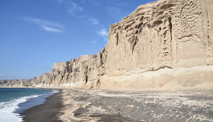
The cliffs look like a bas-relief sculpted by a tireless artist. Naturally carved by the wind and sea, Vlychada’s white cliffs border its black sands, on the southern shore of Thera (Santorini), Greece. Both are of volcanic origin. The material originates from the Late Bronze Age eruption around 1600 BCE, which also buried the prosperous Akrotiri settlement. This massive Plinian eruption led to th ...[Read More]

GeoLog

Imaggeo on Mondays: Sampling sulfurous sinkhole water

Imaggeo on Mondays: Sampling sulfurous sinkhole water

Sampling of water present in sinkhole formed in superficial salt-rich lacustrine deposits at Ghor Al-Haditha, Dead Sea eastern shore, Jordan, during a field campaign in October 2018. The water in this sinkhole flows into the Dead Sea in a surface stream channel formed in 2012. The water was highly acidic and extremely conductive, with a strong sulfurous odour. Understanding the chemistry of the wa ...[Read More]

GeoLog

Imaggeo on Mondays: When boulders hitch a ride from glaciers

Imaggeo on Mondays: When boulders hitch a ride from glaciers

Glen More, on the Isle of Mull, Scotland, is a classic locality for studying glacial landforms and sediments. Here, two prominent ice-transported boulders stand guard at the head of the valley, left behind after the Loch Lomond Readvance (Younger Dryas stade), the final pulse of Quaternary glaciation in Scotland. Behind them in the characteristic U-shaped valley, hummocky morraines are littered wi ...[Read More]

GeoLog

Imaggeo on Mondays: The best of imaggeo in 2019

Imaggeo on Mondays: The best of imaggeo in 2019

Imaggeo, our open access image repository, is packed with beautiful images showcasing the best of the Earth, space and planetary sciences. Throughout the year we use the photographs submitted to the repository to illustrate our social media and blog posts. For the past few years we’ve celebrated the end of the year by rounding-up some of the best Imaggeo images. But it’s no easy task to pick which ...[Read More]

GeoLog

Imaggeo on Mondays: Happy holidays!

Imaggeo on Mondays: Happy holidays!

The EGU wishes all our readers happy holidays and very warm wishes for the new year. And for a chance to be featured on GeoLog throughout the new year, don’t forget to submit your field and lab based photographs and other visuals to Imaggeo: our open access image repository. All geoscientists (and others) can submit their photos and videos to this gallery and, since it is open access, these images ...[Read More]

GeoLog

Imaggeo on Mondays: Rain on the Namib Desert

Imaggeo on Mondays: Rain on the Namib Desert

Pictured here is the arid Namib Desert on a not-so-arid day. The desert is known for its extremely dry conditions and abundance of sunshine, but this photo, taken by Christoph Schmidt, chair of geomorphology at the University of Bayreuth in Germany, gives us a rare glimpse of a rainy day. The Namib Desert spans about 81,000 square kilometres in southwest Africa, stretching throughout the entire co ...[Read More]

GeoLog

Imaggeo on Mondays: Setting trees aflame to understand the carbon balance of fires

Imaggeo on Mondays: Setting trees aflame to understand the carbon balance of fires

Smoke clears after an experimental wildfire in Australian eucalyptus forest carried out for carbon balance estimations of wildfires. We meticulously measured the carbon in all leaves, twigs, logs and bark in a forest block about 35km east of Manjimup and then they set it on fire with help from the Dept. of Parks and Wildlife, [Western Australia]. We the counted the carbon all over again including ...[Read More]

GeoLog

Imaggeo on Mondays: Mount Bromo – volcanic deity

Imaggeo on Mondays: Mount Bromo – volcanic deity

Featured in this photo, rising out from a sea of violet fog at dawn, is one of Indonesia’s most iconic volcanoes, Mount Bromo. The mountain is a large volcanic crater, also known as a caldera, which formed when an ancient cone volcano collapsed in the late Pleistocene and early Holocene epochs, between 126,000 and 8,300 years ago. The current structure stands at 2,392 metres in the eastern region ...[Read More]

GeoLog

Imaggeo on Mondays: Journey to Bolivia’s Laguna Negra

Imaggeo on Mondays: Journey to Bolivia’s Laguna Negra

This week’s featured photo showcases one of the most geologically diverse landscapes of South America: the Altiplano, the high plateau of the Andes. This plateau covers roughly 200,000 square kilometres in central South America, stretching from southern Peru to northern Argentina. The high-elevation plain sits between the eastern and western chains of the Central Andes and is home to a myriad of n ...[Read More]

GeoLog

Imaggeo on Mondays: Great sand dunes and beyond

Imaggeo on Mondays: Great sand dunes and beyond

Driving eastwards through the San Luis Valley in south central Colorado, United States, the Great Sand Dunes emerge at the foot of the Sangre de Cristo Range in the northeast of the region’s upland plain. The origin story of these great dunes begins during a time of glacial melt, five to three million years ago, when the rivers of the surrounding mountains filled the basin with water and sediments ...[Read More]