EGU Blogs

499 search results for "Imaggeo on Mondays"

GeoLog

Imaggeo on Mondays: America’s dead sea

Imaggeo on Mondays: America’s dead sea

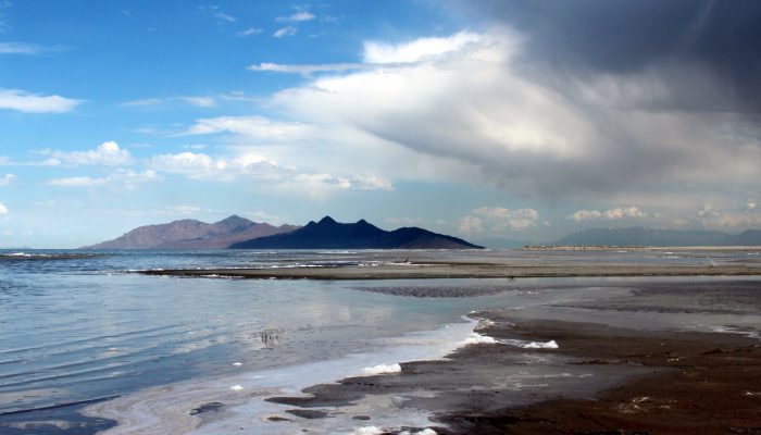
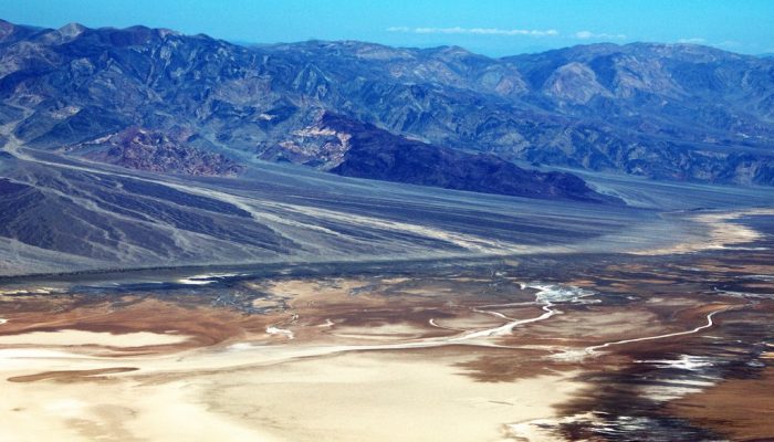
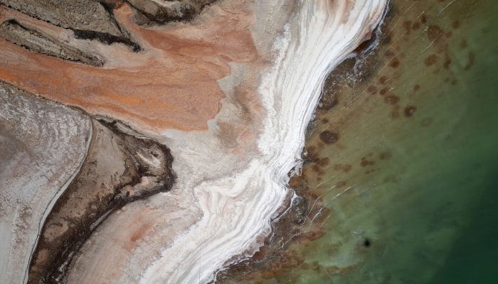
On the blog today, Jennifer Ziesch, a researcher at the Leibniz Institute for Applied Geophysics, takes us on a tour of the Great Salt Lake, located in the north of Salt Lake City (Utah). Did you know it is one of the largest salt water lakes in the world? The large salt lake and Salt Lake City, named after the lake, lie on a flat plain about 1300 m above sea level. The salt lake is bordered to th ...[Read More]

GeoLog

Imaggeo on Mondays: Deep in the Himalayas

Imaggeo on Mondays: Deep in the Himalayas

The Himalayas: vast, formidable and home to the Earth’s highest peaks. The mountain range stretches inexorably through Indian, Bhutan, Nepal, China (Tibet) and Pakistan separating the Tibetan Plateau to the north from India’s alluvial plains to the south. India, as we know it today, started life much further south, as an island not far off the coast of Australia. It was separated from ...[Read More]

GeoLog

Imaggeo on Mondays: Life on bare lava

Life on bare lava

There are plenty of hostile habitats across the globe but some flora and fauna species are resourceful enough to adapt and make extreme environments their home. From heat-loving ants of the Sahara to microbes living in the light-deprived ocean depths, through to beatles who brave the bitterly cold Alaskan winter, there are numerous examples of plants, animals and bugs who strive in environments of ...[Read More]

GeoLog

Imaggeo on Mondays: littoral rainforests

Littoral rainforests

Making room for growing populations, and the resources they demand, comes at the cost of precious natural environments. Rainforests, globally, are under threat from farming, logging and ever expanding cities. It is reported that if current rates of exploitation continue, the world’s rainforests could be lost within the next century. Like almost anything else, rainforests come in all shapes a ...[Read More]

GeoLog

Imaggeo on Mondays: the remotest place on Earth?

Imaggeo on Mondays: the remotest place on Earth?

Perhaps a bold claim, but at over 4,000 km away from Australia and 4,200 km from South Africa, Heard Island is unquestionably hard to reach. The faraway and little know place is part of a group of volcanic islands known as HIMI (comprised of the Heard Island and McDonald Islands), located in the southwest Indian Ocean. Shrouded in persistent bad weather and surrounded by the vast ocean, Heard Isla ...[Read More]

GeoLog

Imaggeo on Mondays: Don’t miss the abstract deadline

Imaggeo on Mondays: Don’t miss the abstract deadline

The EGU General Assembly brings together geoscientists from all over the world to one meeting that covers all disciplines of the Earth, planetary and space sciences. The conference is taking place in Vienna on 23–28 April 2017, providing an opportunity for both established scientists and early career researchers to present their work and discuss their ideas with experts in all fields of the geosci ...[Read More]

GeoLog

Imaggeo on Mondays: Tones of sand

Tones of Sand

With rocks dating as far back as the Precambrian, mountain building events, violent volcanic eruptions and being covered, on and off, by shallow seas, Death Valley’s geological history is long and complex. Back in the Cenozoic (65 to 30 million years ago), following a turbulent period which saw the eruption of volcanoes (which in time would form the Sierra Nevada of California) and regional uplift ...[Read More]

GeoLog

Imaggeo on Mondays: Ice drilling

Ice drilling in Saratov

This week’s Imaggeo on Monday’s post, captured by Maksim Cherviakov, shows students from Saratov National Research University practicing a method to measure lake ice thickness. The students are using an ice auger to manually burrow through the ice. Afterwards, the ice depth is recorded using a tape measure. “We measure ice thickness every year on the lakes located in the floodplain of the Vo ...[Read More]

GeoLog

Imaggeo on Mondays: “Vancouver! Vancouver! This is it!”

Mount St Helen's, Washington, seen from Johnston Ridge.

On May 18th 1980 Mount St Helens (an active stratovolcano of the Cascades located in the North West US), erupted explosively following a magnitude 5.1 earthquake. The quake triggered a devastating landslide which swept away the volcano’s northern flank – in what is the largest debris avalanche recorded on Earth to date. Removal of a section of the edifice depressurised the volcano’s magmatic ...[Read More]

GeoLog

Imaggeo on Mondays: The shrinking of Earth’s saltiest lake

One of the consequences of the rapid fall of the water level (>1 m per year), is that vast areas of salt-rich ground of the shrunken Dead Sea are prone to strong dissolution and mechanical erosion of the subsurface processes.

The Dead Sea is one of the saltiest lakes on Earth, located at the lowest point of the globe.  For centuries it has been known for the restorative powers of its muds and waters. Their hypersalinity means it is possible to easily float on the lake’s surface. Bordering Israel, the West Bank and Jordan, it is a unique environment in an otherwise arid region.  Changing climate, which is seeing tempera ...[Read More]