EGU Blogs

499 search results for "Imaggeo on Mondays"

GeoLog

Imaggeo on Mondays: Arctic cottongrass in Svalbard

Imaggeo on Mondays: Arctic cottongrass in Svalbard

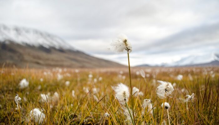
In the High Arctic, where vegetation is limited in height, cottongrass stands out as some of the tallest plant species around. This photo shows a wispy white patch of Arctic cottongrass growing amongst other tundra vegetation in the Advent river floodplain of Adventdalen, a valley on the Norwegian archipelago island Svalbard. Svalbard is of particular scientific interest as it is a relatively warm ...[Read More]

GeoLog

Imaggeo on Mondays: Science in the Arctic trenches

Imaggeo on Mondays: Science in the Arctic trenches

Pictured here are climate scientists processing ice core samples in the East Greenland Ice-core Project (EastGRIP) science trench 10 m under the surface of the Greenland ice cap. The trenches of this ice core camp require minimum building materials, utilising giant inflatable balloons that are dug in and covered with snow. The snow is left to compact for a few days, thereafter leaving back an arch ...[Read More]

GeoLog

Imaggeo on Mondays: The breath of our Earth

Imaggeo on Mondays: The breath of our Earth

This picture was taken in the Myvatn geothermal area in southeast Iceland. Seeing the geothermal steam vent in this area while the temperature was -22 degrees Celsius is the best experience in Myvatn. The difference between Iceland’s cold ambient temperature and the released heat from inside the Earth is a really stunning event to see. Iceland is situated in the middle of two tectonic plates (the ...[Read More]

GeoLog

Imaggeo on Mondays: Hints of an eruption

Imaggeo on Mondays: Hints of an eruption

The photograph shows water that accumulated in a depression on the ice surface of Vatnajökull glacier in southeastern Iceland. This 700m wide and 30m deep depression [1], scientifically called an ‘ice cauldron’, is surrounded by circular crevasses on the ice surface and is located on the glacier tongue Dyngjujökull, an outlet glacier of Vatnajökull. The photo was taken on 4 June 2016, less than 22 ...[Read More]

GeoLog

Imaggeo on Mondays: A Colombian myth with geologic origins

Imaggeo on Mondays: A Colombian myth with geologic origins

This photograph shows El salto del Tequendama, a natural waterfall of Colombia, located in the Department of Cundinamarca at an altitude of 2400 metres above sea level and approximately 30 kilometres southwest of the country’s capital, Bogotá. The Salto del Tequendama is a space of transit and connectivity between the warm lands of the Magdalena river basin and the cold lands of the Sumapaz ...[Read More]

GeoLog

Imaggeo On Mondays: Reservoir in the Italian Alps

Imaggeo On Mondays: Reservoir in the Italian Alps

Mountain natural streams and reservoirs have a relevant hydrological and ecological importance since they represent reliable sources of freshwater supply to lowland regions and high-quality habitats for fish and cold-water communities. Moreover, streams in mountain environments are of significant importance for users in several socio-economic sectors, such as agriculture, tourism and hydropower. G ...[Read More]

GeoLog

Imaggeo on Mondays: A volcanic point of view

Imaggeo on Mondays: A volcanic point of view

It’s not every day that you can peer into a volcano, much less gaze out at the sky from the inside of one. The Algar do Carvão, or “the Cavern of Coal,” is one of the few places on Earth where you can explore the underground reaches of a volcanic site. The volcanic pit is found on the island of Terceira, part of the Azores archipelago. This collection of islands is an autonomous region of Portugal ...[Read More]

GeoLog

Imaggeo on Mondays: River in a charoite schist

Imaggeo on Mondays: River in a charoite schist

Polarized light photomicrograph of a thin section of a charoite-bearing schist. Charoite is a rare silicate found only at one location in Yakutia, Russia. For its beautiful and uncommon purple color it is used as a semi-precious stone in jewelry. Under the microscope charoite-bearing rocks give an overall feeling of movement, with charoite forming fibrous mats that swirl and fold as a result of de ...[Read More]

GeoLog

Imaggeo on Mondays: Probing the Pliocene

Imaggeo on Mondays: Probing the Pliocene

The heights we go to for science… This photograph shows a member of our team preparing to abseil down a cliff in the Charyn Canyon, in the Ili River basin of southeast Kazakhstan. The Charyn River and its tributaries, a branch of the Ili River north of the Tien Shan Mountains, have cut canyons up to 300 metres deep, carving through rocks of different geologic ages, some as old as 540 million years ...[Read More]

GeoLog

Imaggeo on Mondays: Iceland’s original birch forest

Imaggeo on Mondays: Iceland’s original birch forest

Iceland is a country of dramatically rugged landscapes. The region is home to sweeping valleys and mountain ranges, dotted with lava fields, large glaciers, hot springs and impressive waterfalls. The territory is also notoriously treeless. As of 2016, forests only made up 1.9 percent of Iceland, according to the Icelandic Forest Service. However, about a thousand years ago the country’s landscape ...[Read More]