Thermal imaging using infra-red cameras is now a widely used tool in the monitoring and analysis of volcanic explosions, and this pair of time-series snapshots of two short-lived ‘Vulcanian‘ explosions at Volcán de Colima, Mexico, shows one example of why. In each panel, times (in seconds) are times since the start of the explosion sequence; and the temperature scales (vertical colour ...[Read More]
The destruction of St Pierre, Martinique: 8 May, 1902
May 8th marks the anniversary of one of the worst volcanic disasters on record: the destruction of St Pierre, Martinique, in 1902, at the climax of the eruption of Mont Pelée. Below are a snapshot of images from one of the contemporary accounts of the disaster, ‘The volcano’s deadly work‘, written by Charles Morris in 1902. This eruption followed just one day after a similarly de ...[Read More]
‘An amazing and portentous summer..’
Book review: Island on Fire, Alexandra Witze and Jeff Kanipe In Island on Fire, Alexandra Witze and Jeff Kanipe take the reader on a dramatic tour of volcanic eruptions, death and destruction. At its heart is the story of the great 1783-1784 Laki fissure eruption, one of the most significant historical eruptions of Iceland, which belched 120 million tonnes of sulphur dioxide into the atmosphere, a ...[Read More]
Growth of the Kameni Islands Volcano, Santorini, Greece
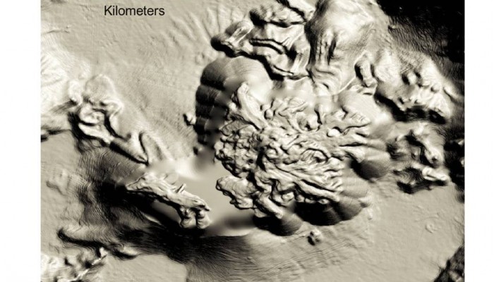
The Kameni islands, Greece
A new paper, published in the journal GeoResJ, reveals the intricate details of the volcanic Kameni islands that lie in the flooded caldera of Santorini, Greece. The Kameni islands started growing shortly after the explosive eruption that formed much of the present day caldera. For the past 3500 years or so these islands have grown in pulses, with each new eruption adding more material to the edif ...[Read More]
Small volcanic eruptions and the global warming ‘pause’
A new paper in Nature Geoscience by Santer and colleagues revisits the volcanic scenarios used in modern climate model simulations. The authors consider the effects of including a ‘more realistic’ model for the influence of small volcanic eruptions on the climate system over the past two decades. Of course, more realistic means more difficult.. and one of the long-standing and unresolv ...[Read More]
Update on the eruption of Gunung Kelud
The dramatic eruption of Gunung Kelud, or Kelut, led to a flurry of images of ash appearing on many social media platforms, including Flickr, Instagram and Twitter. As an experiment in a volcanology class, we sought out images that we could locate on a map, and by classifying the ash deposits as ‘light’, ‘moderate’ or ‘heavy’, generated a very rough contour map ...[Read More]
The eruption of Kelut, Java, February 2014
I have used storify.com to put together a synopsis of the February eruption of Kelut, Java, Indonesia. There are some additional links to more detailed posts and related information below. Related posts Fascinating technical analysis of the satellite data from Nicarnica Aviation Erik Klemetti on Wired Volcano Discovery updates on Kelud Satellite imagery collated by Imageo on Discover Magazine Coll ...[Read More]
The Kameni islands, Santorini, Greece
A glimpse of the spectacular Kameni or ‘burnt’ islands of Santorini, Greece from the air reveals in intricate detail the overlapping lava flows, explosion craters and fields of volcanic ash from which the islands have been built in successive eruptions over the past 2000 years, and more. Of course, what we can see from the air is just the literal ‘tip’ of the present-day vo ...[Read More]
Friday Field Photo – Alutu volcano, Ethiopia
Update: June 2015 Our open access research paper on Aluto volcano is now available online: Hutchison et al., 2015, Structural controls on fluid pathways in an active rift system: A case study of the Aluto volcanic complex, Geosphere 11, 542-562, doi:10.1130/GES01119.1
A volcanic retrospective: eruptions of the Soufrière, St Vincent
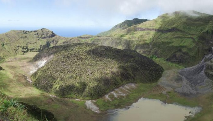
SV Crater
The records, reports and testimonies of past volcanic eruptions and their consequences contain a wealth of information from which we can learn valuable lessons. This, in a nutshell, is the starting point of one strand of the STREVA project, ‘Strengthening Resilience in Volcanic Areas‘, which is a large programme funded by two British funding agencies (NERC and ESRC) and directed from t ...[Read More]