The records, reports and testimonies of past volcanic eruptions and their consequences contain a wealth of information from which we can learn valuable lessons. This, in a nutshell, is the starting point of one strand of the STREVA project, ‘Strengthening Resilience in Volcanic Areas‘, which is a large programme funded by two British funding agencies (NERC and ESRC) and directed from the University of East Anglia by Jenni Barclay. This week, researchers from the STREVA team met in a workshop on St Vincent, a luxuriantly vegetated volcanic island in the southern Caribbean, to see what can be learned from the past history of this volcano and how this learning can be used mitigate the risks of future volcanic activity.

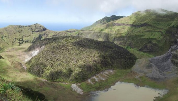
Spectacular view across the crater of the Soufrière St Vincent, showing the lava dome that erupted in the centre of the crater in 1979-1980, and signs of recent land-sliding. The crater walls have been gradually enlarged and re-cut by successive eruptions, and their internal layers reveal the past volcanic history of the Soufrière.
Photo by Paul Cole, University of Plymouth, January 2014.

Aerial view of the south-east corner of St Vincent, looking north along the windward coast. Inland, the topography is rugged, and often heavily vegetated, and rises towards the active volcano, the Soufriere of Sty Vincent, which is hidden under cloud at the top left of the picture. The new airport runway, at Argyle, runs across the brown strip of land forming the eastern-most headland.
St Vincent is a volcanic island, and part of the arcuate chain of the Lesser Antilles volcanic arc. The active volcano on St Vincent is called the Soufrière; a name that describes its sulfurous nature, and shared by other volcanoes in the Antilles including the Soufrière Hills volcano (Montserrat), and the Soufrière of Guadeloupe. While the geological record of past eruptions of St Vincent stretches back for hundreds of thousands of years, the historical record of known eruptions is short, but dramatic.
The first known explosive eruption of St Vincent was in March 1718. By all accounts this was a major eruption, preceded by an extended period of felt earthquakes. While there are no known first-hand descriptions of this eruption, a writer, thought to be Daniel Defoe, published an “An account of the Island of St. Vincent in the West Indies, and of its entire destruction on the 26th March last” in the Weekly Journal or Saturday’s Post of July 5th, 1718 (also known as Mist’s Journal), based on correspondence from ships that had been in the vicinity. This describes a short, but violent explosive eruption “They saw in the night that terrible flash of fire, and .. heard innumerable clashes of thunder”, and the fallout of ash far downwind “In the afternoon they were surpriz’d with the falling of something upon them as thick as smoke but fine as dust, and yet solid as sand ; some ships had it nine inches, others a foot thick, upon their decks; the Island of Martenico [Martinique] is covered with it at about 7 to 9 inches thick; at Barbadoes it is frightful, even to St. Christophers it exceeded four inches.” Defoe’s account became well known when it was later included in a collection of his works (Romances and Narratives, Volume 15, edited by George Aitken and published in 1895/6).
The first detailed account of the crater of the Soufrière dates to 1784 – when Alexander Anderson, then curator of the Botanic Gardens of St Vincent, wrote an account of “The mountain of Morne Garou in the island of St Vincent and the volcano in its summit“. This letter was published in the Philosophical Transactions of the Royal Society, along with a fabulous plate showing the crater, partly filled with water and with a steaming dome (of what we now know to be lava) at its centre. In many respects, this view is remarkably similar to the state of the crater at the present day.
The next major eruption of St Vincent occurred in 1812, in an event which was captured dramatically both in written reports, and in a painting by JMW Turner (The eruption of the Souffrier Mountains, in the Island of St Vincent, at midnight on the 30th of April, 1812, from a sketch taken at the time by Hugh P. Keane). The observer who provided the sketch, Hugh Perry Keane, was a barrister and plantation owner; his diary of the eruption survives in an archive in Virginia, but not the sketch.

‘Description of the eruption of the Souffrier Mountain on Thursday night the 30th April 1812, in the island of Saint Vincent’. Extract from the Report from the Committee on Petition of Persons Interested in Estates in the Island of Saint Vincent, Parliamentary Papers of the House of Commons, Printed by Command, 7 May 1813, pp 182-193. The same description was published in The Times newspaper of 30 June 1812.
British Parliamentary Papers from 1813 contain a ‘Description of the eruption of the Souffrier Mountain on Thursday night the 30th April 1812, in the island of Saint Vincent’ which introduces the volcano and describes the precursory activity. This account had previously been published in The Times newspaper, and appears to be based on written testimonies from residents on the island that had been sent to the newspaper.
“The Souffrier Mountain, the most northerly of the lofty chain running through the centre of this island .. had for some time past indicated much disquietude; and from the extraordinary frequency and violence of Earthquakes, which are calculated to have exceeded two hundred within the last year, portended some great movement or eruption..“. This account also provides a vivid and detailed description of the short-lived but violent eruption, and its immediate aftermath: “The birth of May dawned like the day of judgement. A chaotic gloom enveloped the mountain, and an impenetrable haze hung over the sea with black sluggish clouds of a sulphurous cast; the whole island was covered with .. cinders, scoria and broken masses of volcanic matter.”
A petition from landowners across the island to the British Government outlined the extent of losses and damage from the eruption, explaining that parts of the island “have suffered in an extreme degree; the showers of volcanic matter .. having covered the whole surface of the ground [in that area] about ten inches deep;.. but most providentially, not many lives were lost.”
Nearly a century went by before the next eruption; a hugely destructive event that began in earnest on 7th May 19o2, just a day before the destruction of St Pierre on the nearby island of Martinique, following the eruption of Mont Pelée. The 1902 – 1903 eruptions of St Vincent resulted in a great loss of life (at least 1500), and severe economic impacts, all of which were widely documented in articles and reports at the time. As a result, we have a fantastic archive of primary observations, data and material to work with as we set out to investigate, retrospectively, the nature and consequences of the 1902 eruption – a type of event which has occurred three times in the past 300 years.
Documentary evidence from this eruption includes the correspondence, reports and photographs from the wonderfully named Tempest Anderson, an opthalmologist, photographer and early volcano-tourist. Anderson was rapidly commissioned to make a field visit to the island, which he published in early 1903. As this letter to the Royal Society attests he was a stickler for detail, and his accounts and photographic records from the time make for astonishing reading.

Letter from Tempest Anderson to the Assistant Secretary, Royal Society, from the Royal Society Archives.
Feb 15., 1903.
‘Dear Sir, with reference to the Plates for the Report on the Volcanic Eruptions in the West Indies which have been engraved by Collings from my negatives, I wish to inform you that Dr Flett and I have had great difficulty with Collings and have only at last with considerable perseverance been able to [over] get satisfactory proofs. As even now it is quite possible that some failures may occur when they are carefully printed I would be much obliged if you could arrange for printer pulls of all the plates be sent to me before the printing is finally proceeded with …’
Meanwhile, the details of the eruption and its effects are exhaustively recorded in Colonial Reports and Parliamentary Papers from the time.

Colonial Reports – Annual – for 1902-1903. St Vincent. ‘All minor events are eclipsed by the appalling eruption of the Soufrière volcano, which on 7th May awoke from its 90 years’ slumber to again hurl death and devastation over nearly one-third of the hapless Island of St Vincent‘, Edward J Cameron, Administrator.
After 1903, Soufrière St Vincent returned to a state of quiescence which wasn’t disturbed until 1971, when a remarkably quiet eruption built a new lava dome within the flooded crater of the volcano. This new activity, and the subsequent unrest on the nearby island of Guadeloupe in 1976, helped to stimulate the expansion of networks of instruments, including seismometers and tiltmeters, to monitor the volcano. This investment paid off quickly, with the rapid onset of new activity in 1979.
The 1979 eruptions began with only a very short period of unrest, starting with a strong local earthquake on April 12. Eruptive activity began with a series of short-lived but violent explosions and that lofted a series of ash plumes, high into the sky on April 13, 1979; Good Friday. This heralded two weeks of vigorous activity that peaked with an 18 km high plume on April 17, and ended, with the cessation of measurable seismicity on April 29. After this, the eruption switched to the quiet extrusion of lava, slowly forming the dome that still sits in the crater today. The 1979 eruption caused much disruption, with 20,000 people evacuated to shelters, but no direct loss of life.
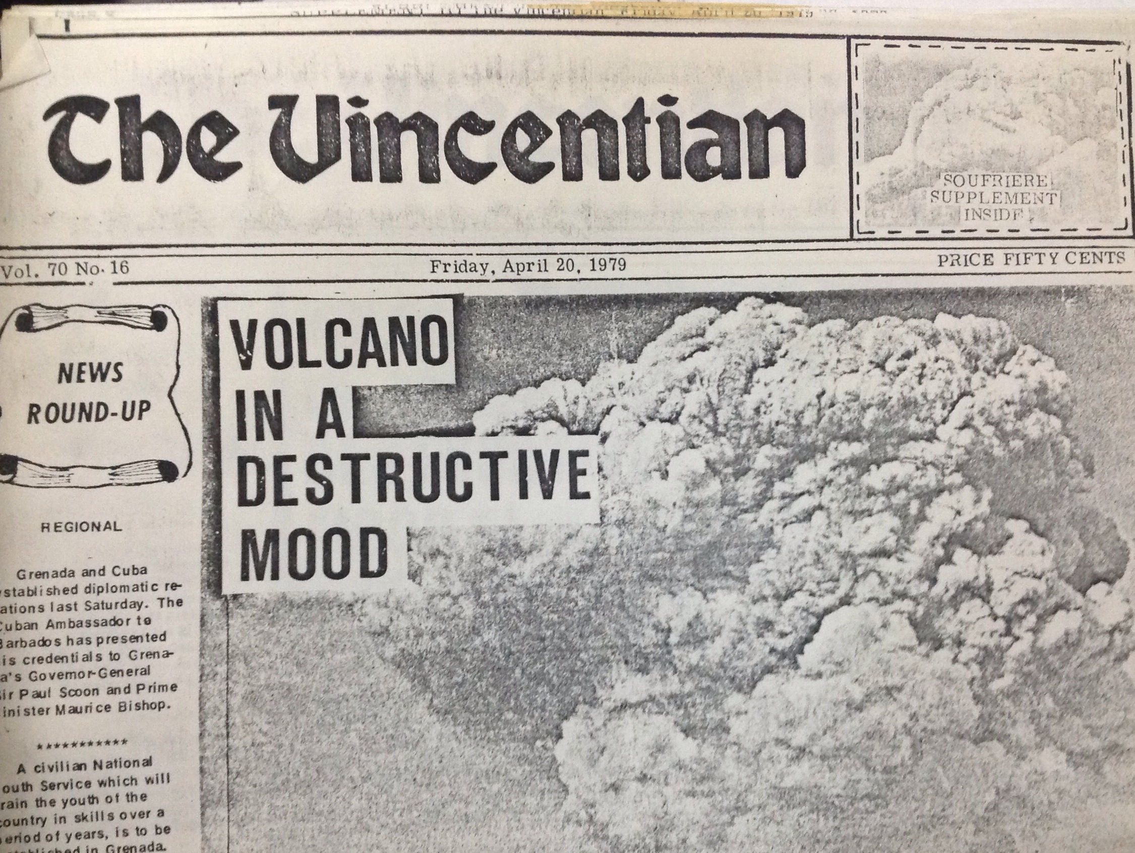
The Vincentian newspaper, Friday 20 April 1979 – one week into the eruption.
One of the goals of the workshop on St Vincent was to find out from the residents of St Vincent and neighbouring islands about the current awareness of volcanic risk, and risk communication. Participants included representatives of emergency management organisations both from St Vincent and the Caribbean region, as well as residents of St Vincent from all walks of life, including those with direct experience of the eruptions of the 1970’s, and people currently charged with reponsibilities across the spectrum of disaster management and response, both in the public and private sectors. This was a tremendous experience, and the STREVA team arel now working hard to analyse the results, develop new ideas and share understanding of how best to improve preparedness for future volcanic unrest and the response to future volcanic emergencies.
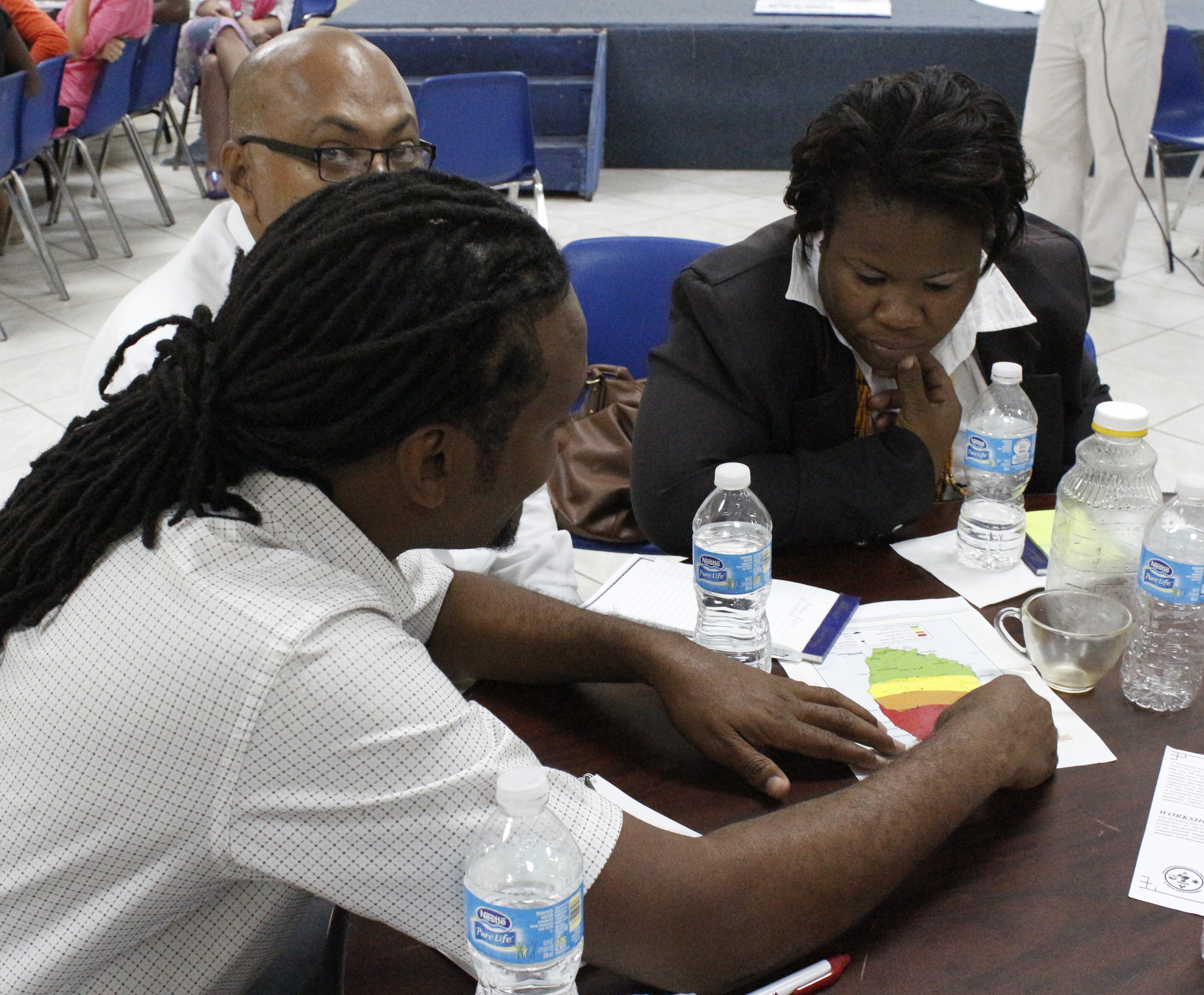
Workshop discussions of the likely response to a future volcanic scenario, focussing on the current volcanic hazard map of St Vincent.
Acknowledgements
I wish to thank archivists and librarians at the Royal Society, the Geological Society of London, the National Archives of St Vincent and the Grenadines, the Barbados Museum and Historical Society, the British Library, Cambridge University Library and the Bodleian Libraries, University of Oxford, for access to archives and literature sources. Many thanks also to Paul Cole for the wonderful photo of the crater, to Willy Aspinall for the trails to Daniel Defoe and JMW Turner, and to Anna Hicks and Jenni Barclay for all of their work in putting the workshop together.
The STREVA project is funded by UK Research Councils NERC and ESRC under the Improving Resilience to Natural Hazards programme.
The workshop on St Vincent was supported by the National Emergency Management Organisation (NEMO) of St Vincent and the Grenadines, the Caribbean Disaster Emergency Management Agency (CDEMA), and the University of the West Indies Seismic Research Centre and we acknowledge the support of many people and organisations both in St Vincent and across the Caribbean for their contributions to the discussions and for helping to make this event such a success.
Related Posts
Post on the Botanic Gardens of St Vincent and the Grenadines.
Report on the STREVA workshop on Montserrat, October 2012: Montserrat, Open for Business.
Field Photo, Soufrière Hills Volcano, Montserrat, 1998.
Post from Charly Stamper – Soufrière Saint Vincent on the blog Between a Rock and a Hard Place.
londonvolcano
Reblogged this on londonvolcano and commented:
An introduction to the past activity of the Soufrière volcano, St. Vincent, and some of the sources describing these past eruptions.
Pingback: The Island | Volcano Gameplay
Pingback: There’s (volcanic) dust in the archives | volcanicdegassing
Pingback: Under the volcano – londonvolcano
Pingback: “I’ll never forget that day” – 36th Anniversary of La Soufriere, St. Vincent | Volcano Gameplay
Pingback: “When I played the game, I saw those clouds all over again” | Volcano Gameplay
Pingback: 'Explosive Eruption' Rocks St. Vincent as Soufriere Volcano Spews Ash Across the Caribbean | Masoud ILDEREMI
Pingback: Soufriere Volcano's 'Explosive Eruption' Rocks St. Vincent - View Orbit
Pingback: Saint Vincent hit by the explosive eruption of the Soufriere volcano – JT NEWS
Pingback: St. Vincent Hit by Soufriere Volcano ‘Explosive Eruption’ - 5Gigbucks News
Pingback: St. Vincent Hit by Soufriere Volcano 'Explosive Eruption' - 365 News Channel
Pingback: St. Vincent Hit by Soufriere Volcano ‘Explosive Eruption’ – BuytechNow.UK