EGU Blogs

Environmental Change

Lake mud can offer a crucial long-term perspective on flooding

Lake mud can offer a crucial long-term perspective on flooding

The severe flooding that has hit much of northern England during the last few weeks (and northeastern Scotland right now) has generated significant discussion and debate about why floods happen, how often they occur and what we can do about it. The fact is there’s no simple answer to any of these questions: the hydrometeorological cycle is a complex beast and our actions have altered it in myriad ways, from contributing to a warming climate, modifying flow pathways and building in less-than-ideal locations. I recently co-authored a piece at The Conversation that offers some wider context to these discussions.

https://commons.wikimedia.org/wiki/File:Wetherby_Bridge_during_the_December_2015_floods_%2826th_December_2015%29_001.JPG

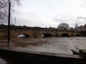
Wetherby Bridge, 26 December 2015. Photo by: MTaylor848 (WikiCommons).

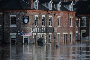
https://commons.wikimedia.org/wiki/File:York_Floods_2015_-34.jpg

Flooding in York, 27 December 2015. Photo by: Richard Scott (WikiCommons).

While the physics dictating that a warmer atmosphere can hold more moisture is long established, attributing single weather events to climate change and detecting whether floods are becoming more frequent and/or severe floods here in the UK remains tricky business (e.g., Pall et al. (2011) Nature, Trenberth (2011) Wiley Interdisciplinary Reviews: Climate Change or Trenberth et al. (2015) Nature Climate Change, Watts et al. (2015) Progress in Physical Geography). One complicating factor that is widely accepted is that the short duration of existing hydrological records – typically a few decades or less for river gauging stations – means attempts to identify an anthropogenically-triggered signal from natural variability have produced ambiguous results.

This is where sediment sequences may be able to contribute some valuable data, as floods can leave behind an imprint that is sedimentologically different to the material that accumulates day-to-day on a lake bed or on a floodplain. The field of palaeohydrology has a long history but emphasis has really been placed on lake sediment sequences in the past few years. Two recent comprehensive reviews of the state of lacustrine palaeoflood research (Schillereff et al. (2014) Earth-Science Reviews and a book chapter from Gilli et al. (2012)) highlight much impressive work coming from the European Alps, Scandinavia, North America and indeed globally.

There are a number of crucial considerations: how certain can we be that a distinct layer of sediment was in fact deposited by a historical flood? Do all floods leave an imprint? If not, must an event reach a certain discharge for a detectable deposit to be preserved?

When I started my PhD investigating palaeoflood records from British lakes, I quickly discovered another significant barrier: the difficulty of distinguishing flood layers in lakes that accumulate homogeneous sediments, typically fine-grained, organic-rich material – in other words, squishy brown gloop. These sorts of lakes are common in the UK and globally prevalent, especially in temperate regions.

My ex-PhD supervisors and I published a paper in Geology this month (Schillereff et al. ‘Hydrological thresholds and basin control over paleoflood records in lakes‘) that successfully demonstrates a method to obtain palaeoflood records from such lakes (please note the paper is Open Access). Working at Brotherswater, a small lake in the eastern English Lake District, we were able to confirm the provenance of coarse-grained samples (i.e., they were deposited during high river flows), establish the hydrological threshold at which a sedimentary imprint is preserved (i.e., what discharge is required) and ultimately, we hope, provide a blueprint for acquiring palaeoflood records from these sorts of systems elsewhere in the world.

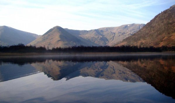
The view south across the catchment of Brotherswater. Photo by: D. Schillereff.

The view south across the catchment of Brotherswater. Photo by: D. Schillereff.

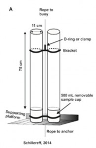
What did the work involve? We installed sediment traps (tubes with exchangeable containers at the bottom – see diagram) in the lake for 18 months enabling us to directly measure the calibre of particles delivered to the lake as incoming river discharge fluctuates through the year. We then looked at sediment cores from the same location; these were made up of material that had accumulated at the lake bed since ~1960 and some of these samples were characterised by very coarse material.

Schematic of the sediment traps installed in Brotherswater. Source: Schillereff, 2014.

Schematic of the sediment traps installed in Brotherswater. Source: Schillereff, 2014.

Statistical analysis of these data indicated there were different groupings of particle sizes that we linked to separate hydrological processes. The coarsest group, or end member, appears in sporadic samples and we infer its appearance to be indicative of a major flood. Our dating of the sediment enables us to pinpoint the timing of each flood and comparing their occurrence with local river flow records has enabled us to establish the discharge threshold that will result in a sedimentary deposit being preserved.

The next image, Figure 3 in our paper, hopefully explains the processing. The left-hand triplet of graphs are the particle size distributions of all samples; the black line (furthest right) in the middle plot represents the coarse fraction. The middle (sediment traps) and right-hand (cores) pairs of graphs depict the contribution each end-member makes through time. The black bars periodically reach well over 50%; material of this calibre almost certainly must have been delivered during high discharges, so we can use its appearance as a palaeoflood signature.
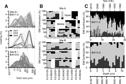
End-member modelling of particle size data from sediment trap and core samples. See text for explanation. Source: Schillereff et al. (2016)

End-member modelling of particle size data from sediment trap and core samples. See text for explanation. Site A is closer to the inflow, site B is in the lake centre. Source: Schillereff et al. (2016)

Having established more confidently the characteristics of palaeoflood laminations, we can begin to examine long sediment cores and count the frequency and calculate the magnitude of floods that have occurred during past centuries and ideally millennia. This work is progressing nicely and we plan to submit our findings from Brotherswater and other regional lakes that place the recent Cumbrian floods (2005, 2009, 2015) in a longer-term context for peer-review this year.
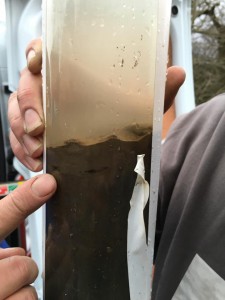
Sediment core extracted from Bassenthwaite Lake, Cumbria, on 7 January 2016. The light-coloured band at the surface most likely reflects material deposited by the severe flood triggered by Storm Desmond in early December. Photo courtesy of R. Chiverrell, University of Liverpool.

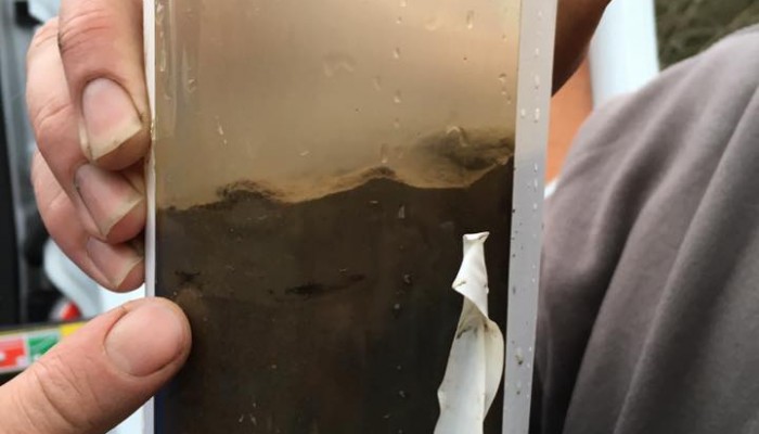
Sediment core extracted from Bassenthwaite Lake, Cumbria, on 7 January 2016. The light-coloured band at the surface most likely reflects material deposited by the severe flood triggered by Storm Desmond in early December. Photo courtesy of R. Chiverrell, University of Liverpool.
Outreach on the slopes.

Outreach on the slopes.

One of the beauties of living in Munich is that the Alps are, practically, on your door step. As I mentioned in one of our more recent posts, now that I am here, I’m looking forward to exploring the city, its surroundings and further afield!

Making it to the top

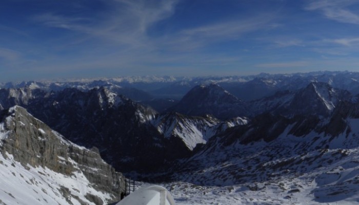
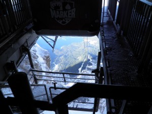
View of the cable car ascent from the Zugspitze summit.

View of the cable car ascent from the Zugspitze summit. Looking north towards Lake Eibsee. (Credit: Laura Roberts)

That is exactly what I did a few weekends ago. After a little research, I chose to visit the town of Garmisch-Partenkirchen, at the foothills of the Alps. I’d discovered it offered some good hiking and that the town itself was lovely too. It turns out it is also home to Germany’s highest peak, the Zugspitze, a 2962 m towering mass or rock, ice and snow. Climbing to the summit is beyond my capabilities but I still found the less challenging alternative to reach the summit is not for the faint hearted either! It starts with a pleasant (but slow) train journey to Lake Eibsee. You then transfer on to a cable-car which transports you from ca. 1000m above sea level, right up to the summit of the Zugspitze in a hair-raising 10 minute (near-vertical) ascent! Like I said, not for the faint hearted! You can make the whole journey on a cog-wheel train (Zugspitzbahn), if you don’t fancy the rather scary cable car.

[Read More]

A much shorter review of flood stratigraphies in lake sediments

A much shorter review of flood stratigraphies in lake sediments

Earlier this year my PhD supervisors and I (Daniel) had a paper accepted for publication in Earth-Science Reviews entitled ‘Flood stratigraphies in lake sediments: A review’ (Schillereff et al., 2014). It’s been fairly popular in terms of downloads but it occurred to me the other day that many of those prospective readers may be put off somewhat by its hefty word count. Thus, putting together a shortened version outlining the main points and conclusions seemed wise!

The review stems from my PhD research investigating whether sediment cores extracted from UK lakes contain distinct layers deposited by severe floods that occurred in past decades or centuries. It follows many neat papers illustrating similar case studies from every continent bar Antarctica. (We’ve included a KML GoogleEarth file in the Supplementary Info enabling users to fly to the sites of each published palaeoflood record mentioned in the text).

[Read More]

Moraines in Costa Rica? Really?

Moraines in Costa Rica? Really?

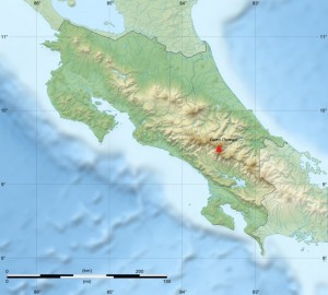
During a recent trip to Costa Rica in May, I had a conversation with some family and friends in which I uttered those words: “Moraines in Costa Rica? Really?” as they were describing a trek they’d undertaken earlier this year to the summit of Cerro Chirripó. This is the highest peak in the country (3819 m a.s.l.), part of the Cordillera de Talamanca (9°30′ N, 83°30′ W) in southern central Costa Rica.

Relief of Costa Rica and location of Cerro Chirripó. Base map courtesy of Sting (WikiCommons CC BY-SA 3.0)

Relief of Costa Rica and location of Cerro Chirripó. Base map courtesy of Sting (WikiCommons CC BY-SA 3.0)

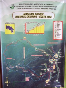
Map board at entrance to Parque Nationale Chirrippo. Photo courtesy of Scott Schillereff.

Map board at entrance to Parque Nationale Chirrippo. Photo courtesy of Scott Schillereff.

While the photographs looked stunning (on a clear day, both oceans are visible from the summit), I was especially intrigued by their description of the landscape surrounding the peak: curved valleys, moraines and other landforms often associated with glacial activity were visible as they were above the tree-line. There are certainly no glaciers there at present (apparently hail occurs occasionally at the summit) and Costa Rica can definitely be classified as a tropical environment today. However this inspired me to track down research confirming (or not) that these landforms are indeed glacial in origin and, if so, discover the timing and duration of this period of high-altitude tropical glaciation.

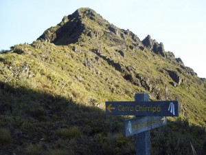
The summit of Chirrippo (trail with hikers on left for scale). Photo courtesy of Scott Schillereff.

The summit of Chirrippo (trail with hikers on left for scale). Photo courtesy of Scott Schillereff.

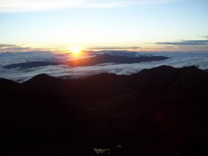
Sunrise over the Caribbean from the summit of Cerro Chirripó. Photo courtesy of Scott Schillereff.

Sunrise over the Caribbean from the summit of Cerro Chirripó. Photo courtesy of Scott Schillereff.

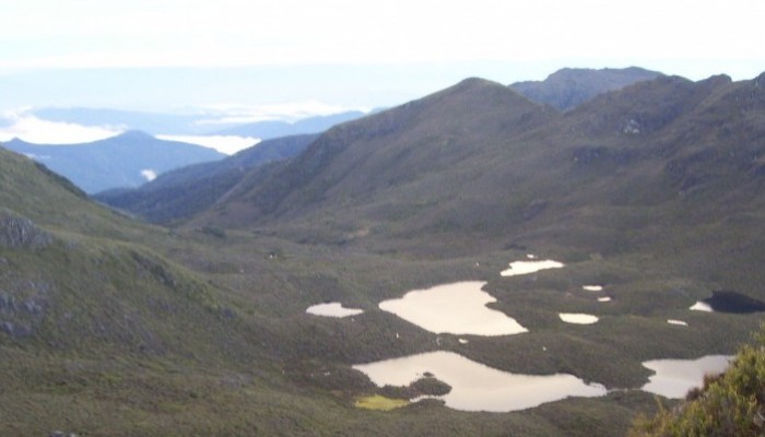
It turns out the first papers on episodic glaciations in Costa Rica and other Central American countries emerged in the 1950s and investigations have continued through to the present day (particularly by researchers at the University of Tennessee). Much of the peer-reviewed research I found for Cerro Chirripó in particular is based on geomorphic surveys as well as analysis of sediment cores extracted from lakes located on valley floors along the flanks of the mountain. Many of these lakes have formed behind what appear to be moraines (see photo). A particularly interesting feature near the base of these sediment cores is a distinct shift from light-coloured material dominated by mineral particles to much darker brown or black sediments rich in organic matter. This transition is observed in lacustrine sequences all over the world, and certainly here in the UK, and is commonly attributed to the transition from the Younger Dryas interstadial at the end of the last glacial period into the early Holocene. The dark, more organic sediments are typical of deposition through the Holocene as the climate warmed and vegetation cover expanded around the world. A series of radiocarbon dates confirm a similar timing for these sediment transitions in multiple lakes around Cerro Chirripó, ranging between 12, 360 and 9, 470 calibrated years Before Present (BP) within the dating uncertainties (Horn, 1990; Orvis and Horn, 2000). The span of these dates likely relates to the relative position of the each lake with respect to the retreating glacier during the period of deglaciation, and the timing corresponds nicely with the Younger Dryas event (12, 900 – 11, 600 cal. yr BP). In fact, evidence for a Younger Dryas re-advance has been reported elsewhere in the neotropics including the Columbian Cordillera, the Eastern Cordillera of Equador, the Cordillera Real in Bolivia and around the Malinche volcano in central Mexico (references are found in Lachniet, 2004).

Panoramic view from summit of Cerro Chirripó with lakes visible in the foreground that have formed behind what appear to be moraines. Photo courtesy of Peter Anderson (WikiCommons CC BY-SA 3.0)

Panoramic view from summit of Cerro Chirripó with lakes visible in the foreground that have formed behind what appear to be moraines. Photo courtesy of Peter Anderson (WikiCommons CC BY-SA 3.0)

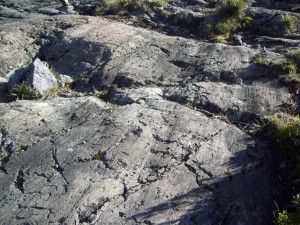
In terms of geomorphic evidence, phases of glacial advance and retreat are recorded by the large medial (a ridge running through the middle of a valley where two glaciers meet), lateral (two parallel ridges on either side of a glacier) and terminal (ridges formed at the end of a glacier) moraines found in the valleys around Cerro Chirripó. These fingerprints are found up to four hundred metres below the summit (Lachniet, 2004). Other field evidence includes striated bedrock (smoothed and grooved rock formed as ice moves across the surface; see photo).

Striated bedrock near Cerro Chirripó. Photo courtesy of Scott Schillereff.

Striated bedrock near Cerro Chirripó. Photo courtesy of Scott Schillereff.

To date, researchers have been unable to find suitable organic material at the base of the moraines to attempt radiocarbon dating but they are assumed to represent the maximum extent of the last ice advance, equating to a total ice-covered area of 35 km2. Similar features found at lower elevations in other parts of the Cordillera may point towards even more extensive ice cover during stages earlier in the Pleistocene but no effort to date these landforms has yet been invested. A recent review paper (Lachniet and Roy, 2011) emphasised that obtaining further radiocarbon dates from the lake sediments and landforms is critical to better understand the timing and duration of local and wider tropical glaciations. They also suggest OSL may be suitable, but cosmogenic radionuclide dating has been largely unsuccessful due to intense weathering of rock surfaces in the humid tropical environment.

Looking into the research and browsing through photographs of Cerro Chirripó has certainly inspired me to aim to hike up the mountain on my next visit to Costa Rica. One of the amazing things about Costa Rica and other Central American countries that I have backpacked through is how much the climate and landscape and culture can vary across relatively short distances – but trying to imagine glaciers sweeping down the valleys is very difficult to imagine!!

References

Horn, S.P. (1990) Timing of deglaciation in the Cordillera de Talamanca, Costa Rica. Climate Research 1, 81-83. PDF

Lachniet, M. (2004) Late Quaternary glaciation of Costa Rica and Guatemala, Central America. In: Ehlers, J., Gibbard, P. (Eds.) Quaternary Glaciations – Extent and Chronology Part III: South America, Asia, Africa, Australasia, Antarctica. Elsevier, Amsterdam, 135-138. DOI: 10.1016/S1571-0866(04)80118-0

Lachniet, M. and Roy, A. (2011) Costa Rica and Guatemala. In: Ehlers, J., Gibbard, P., Hughes, P. (Eds.) Quaternary Glaciations: Extent and Chronology. Elsevier, Amsterdam, 843-848. DOI: 10.1016/B978-0-444-53447-7.00060-X

Orvis, K. and Horn, S.P. (2000) Quaternary glaciers and climate on Cerro Chirripó, Costa Rica. Quaternary Research 54, 24-37. DOI: 10.1006/qres.2000.2142