The Dead Sea is one of the planet’s truly otherworldly places: a peculiarity of water distribution, climate and altitude, it is even more extroadinary in that it is a site of religious, cultural and political significance. Viewed by many as a natural wonder, its characteristics and location within one of the most entrenched political situations in modern history makes it intriguing and troubled in equal measure.
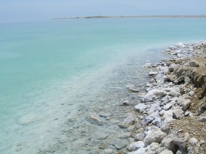
The Dead Sea is the deepest hypersaline lake in the world, situated at the lowest point on earth. It has a salinity of 33.7% due to high concentrations of NaCl and other mineral salts. The Dead Sea, aside from being a misnomer (it is actually an inland lake) is so-called because of the harsh living conditions that the salinity engenders. Many organisms such as fish cannot live there, in fact only populations of bacteria and microbial fungi can thrive.
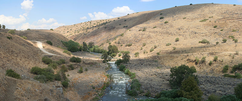
Located in the Jordan rift valley bordering Jordan to the east, and Israel and Palestine to the west, it is served only by the Jordan River to the North. A combination of the mineral content of the water, low content of pollens, the reduced ultraviolet component of solar radiation and the higher atmospheric pressure at this depth have specific health effects which have borne a booming spa-tourism economy. This along with the dramatic scenery and tranquil waters is why it has long been a site of tourism and refuge; King David used it as such and it was one of the world’s first health resorts for Herod the Great.
There are two schools of thought as to how it formed; one is that the depression forms part of the East African rift valley complex and, another more recent hypothesis describes the formation as a ‘step over’ discontinuity along the Dead Sea Transform creating an extension of the crust. The sea was once connected to the Mediterranean and experienced regular flooding, resulting in thick layers of salt deposition. The land between the Mediterranean and the Dead Sea subsequently rose to cut the basin off and create a lake.
What’s the status now?
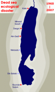
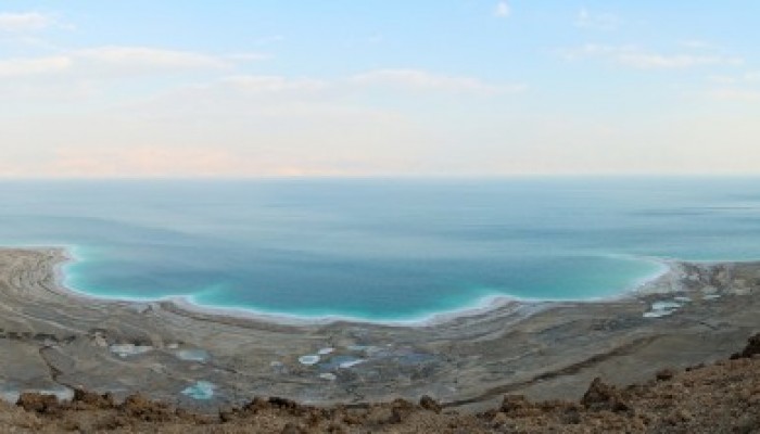
The dwindling water level of the Dead Sea. Source
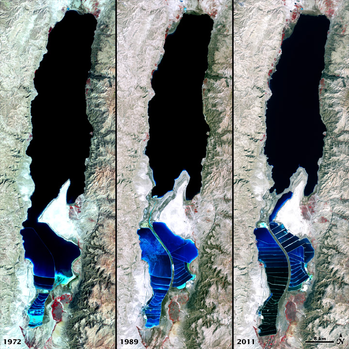
The Dead Sea in more recent years has been characterised by a decline in water levels, a drop of ~30m since 1960 alone and is currently shrinking by around 1m/year. This is in part due to a drop in rainfall and the use of water upstream of the Jordan river for irrigation projects. Declining water levels have resulted in a wide variety of environmental issues for the Dead Sea ecosystems and surrounding region. One such issue is the ever-feared rumble that precedes the formation of sinkholes; these can be unpredictable and can occur suddenly almost anywhere in the Dead Sea region. Indeed, the level of uncertainty and rapidity of sinkhole formation is such that around 10 years ago, renowned geographer-geologist and expert on sinkhole phenomena Eli Raz was swallowed up by one and waited 14 hours for rescue!
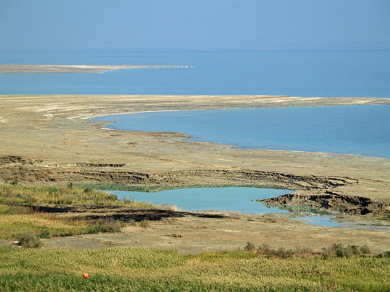
Sinkholes in the Dead Sea area are caused by the interaction of incoming freshwater with subterranean salt layers. As the sea level drops, high levels of salt are left behind in the soil and when freshwater washes in from the Jordan River it dissolves the salts and cavities are created. This process continues until the subterranean structure loses integrity and sinkholes are formed. It is estimated there are now about 3000 in the region of the dead sea with an opening up of around 1 a day.

Sinkholes along the shore of the Dead Sea. Source.
Why is the water level dropping?
Jordan, Syria, Palestine and Lebanon have all tapped the Jordan river for water over the last few decades for irrigation purposes resulting in a reduced flow into the Dead Sea. An area with historically low rainfall, ~ 2 inches a year, enormous amounts of water is also piped off to fill evaporation pools for the potash and magnesium industries which sit at the very southern end of the sea. This alone is thought to result in a 30-40% reduction in water.
In the last 50 years, the population in the surrounding countries of Israel, Palestine and Jordan has increased from 5.3 million to over 20 million with an increase in the settled population in the Dead Sea region. Currently, tens of thousands of tourists visit every year to bathe in the sea and use the many resorts and spas found along the shores and visit the mighty ruin of Masada (including me!) that overlooks the Dead Sea. Tourism is growing in this area and makes up about 40 percent of the income of local residents and this is putting further pressure on diminishing water resources.
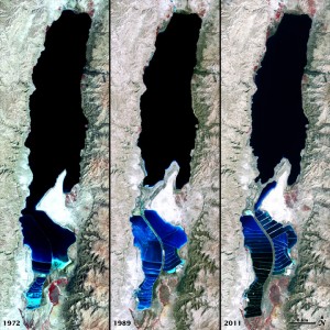
Views of the Dead Sea in 1972, 1989, and 2011 compared. Source.
How can environmental catastrophe be avoided?
The delicate balance of inflows, outflows, evaporation and rainfall has been severely disturbed in the last 50 years, and this hasn’t gone unnoticed. A highly ambitious project is underway to replenish the Dead Sea and ameliorate some of the water and energy shortage issues in the region. The World Bank, together with the local governments is planning to create a canal linking the Red Sea to the Dead sea. The project includes a series of studies including feasibility, environmental and social assessment with the aim of generating a trilateral agreement between Palestine, Jordan and Israel. If the plan goes ahead as detailed, the pipeline will deliver 2 billion cubic metres of sea water per year from the Gulf of Aqaba through Jordanian territory and to the Dead Sea. The plan is to also use the downwards flow between the Red Sea and the Dead sea to incorporate a hydroelectric plant. This is in turn will power a desalination plant which would provide up to 850 million m3 of fresh water per year to a water parched region. The briny discharge from the desalination plant would then be discharged into an already-saline Dead Sea. The project is likely to cost at least US $10 billion, a significant proportion of this is taken up by the cost to pump the desalinated water 200km over an altitude change of 1000m from the Dead sea towards Amman, an extremely parched area.

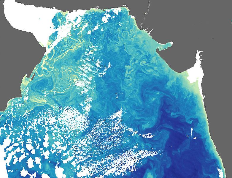
Algal Blooms in the Arabian Sea. Source.
So, it sounds good but is it really that simple? Many studies find that if more than 400 million m3 of sea water is added to the Dead Sea, this could result in the formation of algal bloom and unsightly gypsum crystals, the effects of which have effects that are difficult to predict, this will impact on the image and chemistry of the Dead Sea. Although the ecological effects of these chemical changes are still unclear, they would likely diminish the sea’s tourist appeal. This is in addition to the fact that the amount of water supplied would not be enough to stabilise or increase the level of the Dead Sea. There is also concern about the effects of mixing Red Sea water with Dead Sea water. Many other alternatives have been mooted by environmental groups, such as water recycling and conservation by Israel and Jordan, importing water from Turkey and desalinating sea water on the Mediterranean coast. Whilst pumping desalinated sea water from the Mediterranean to Ammam would be easier and cheaper, the geopolitics are concerning. Many worry that Israel would control the supply to Ammam. Another very real concern is the high frequency of earthquakes in the region, seismic activity could cause salt water to leak into underground fresh water aquifers. Others would prefer to see the rehabilitation of the Jordan River with a greater utilisation of desalination to provide water to the Mediterranean coast. All of these alternatives however require cooperation and a regional approach to water sharing which is difficult in this part of the world to say the least.
Regional Water Security
This issue sits within a wider problem. This is a region with extremely low levels of rainfall and a booming population. Jordan are well behind the Red-Sea-Dead-Sea project largely because the country’s access to fresh water is extremely restricted, which has been exacerbated by the arrival of more than a quarter of a million Syrian refugees since the outbreak of the civil war.
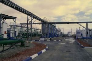
Nitzana desalination plant in Israel. Source.
Israel has long had issues with water scarcity. Due to low rainfall and a booming industry, the demand on water outstrips conventional water resources. This is put under further strain from the water-intensive agricultural practices used throughout the country.This is in part alleviated by their technologically advanced desalination plants dotted along the Mediterranean coast.
Gaza, on the Mediterranean coast is thought to be heading for a serious water crisis in the coming decade with 90-95% of the main aquifer contaminated, the UN suggest the water might be unusable by 2016. Meanwhile water shortages in the West Bank affect the provision of drinking water, water used for farming and agriculture in addition to that required for basic sanitation.
Regional Geopolitics
The regional geopolitics is intensely complex with many historic and current political factors at play. Others can write much more authoritatively on the area but it is worth mentioning here because, as with many geological issues, the interplay between the two is important.
The main regional players are Israel, Palestine and Jordan. Jordan, with few freshwater resources and no oil to power desalination plants, has long been considering an engineered solution to alleviate the water issue in Jordan. At peace with Israel since the signing of a treaty in 1994, the Jordanian government is hoping the plan goes ahead in full.
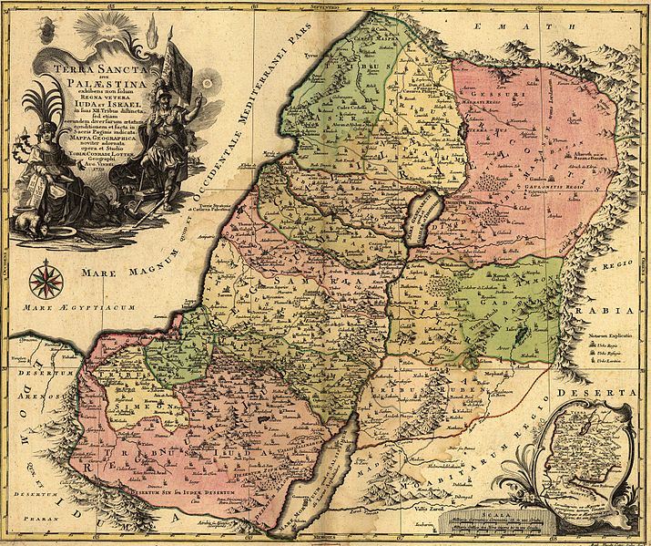
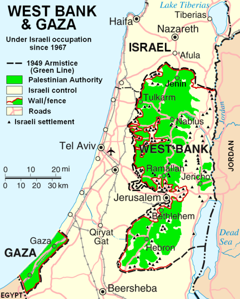
Israel and Palestine are significantly more complicated. The current de facto borders of Israel and Palestine are broadly along the lines drawn following the ‘Six Day War’ in 1967, as seen in the image, where Israel extended its borders and captured, among other territories, the West Bank.
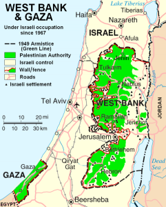
Map of the West Bank and Gaza Strip. Source.
Contemporary Palestine now exists as two non-coterminous territories: the Gaza strip, which is on the Mediterranean coast (run by Hamas) and whose borders are controlled by Israel and Egypt, and the West Bank (the name of which refers to the Jordan River) which borders Israel to the north, south and west, and Jordan to the east. Civil and military authority in the West Bank is a mixture of the Fatah-led Palestinian Authority and the Israeli state. The Dead Sea spans the south east corner of the West Bank, as well as parts of Israel and Jordan. Whilst the West Bank shares a geographical border with Jordan, this is controlled by Israel, and the West Bank remains under Israeli occupation under international law.
In a region with scarce water resources, distribution can be controversial – and Israel’s monopoly over a shared aquifer and access to the Jordan River has resulted in the state being accused of restricting access to water for Palestinians.
Palestine (despite divisions in governance across the two territories) is still seeking independent statehood, and in 2012 was recognised at the United Nations as a ‘Non-member observer state’. As such, negotiations over multilateral initiatives such as the Red Sea-Dead Sea project have enormous geopolitical implications.
Other Cross-boundary Water Conflicts
There are many examples of delicate border regions which cut across natural river systems, such is the nature of modern national borders, they very rarely follow catchment areas and as such control over and use of water bodies can be highly contested.
Cross boundary water engineering negotiation goes on in many areas around the world and these often intersect with political and environmental issues. In addition to the Dead sea and Jordan river the Nile is subject to boundary issues, running through Egypt, Sudan and Ethiopia. Egypt and Ethiopia are currently negotiating over a billion dollar dam project being built in Ethiopia. Egypt are looking to help with the construction of the dam project.
The Caspian Sea has also had more than its fare share of water-rights disputes. A massive sea in Central Asia, its issues descend from the break up of the Soviet Union in 1991 and thus increasing the number of countries with an interest. As such a number of plans have been proposed and rejected due to lack of unanimity leaving the legality and governance of the area up in the air and resulting in resource grabs and export of resources struck without agency.
As with the Dead Sea, these examples show the great complexity in dealing with cross-boundary water management and no situation is the same, and must be dealt with carefully and on a case by case basis.
Flo
Further Reading
BBC News – Project to replenish Dead Sea water levels confirmed
Phys Org – Dead Sea, Red Sea plan raises environmental hackles
Nature – Environmental concerns reach fever pitch over plan to link Red Sea to Dead Sea
Slate – The Dead Sea is Dying


