EGU Blogs

Flo Bullough

Flo is a Policy Assistant at The Geological Society with experience and interests in Water Geochemistry and Environmental Geoscience. She helps to promote the Environment Network & interdisciplinary approaches to geological problems and policy issues. Tweets as @flo_dem.

Rocks in the right place at the right time…

Rocks in the right place at the right time…

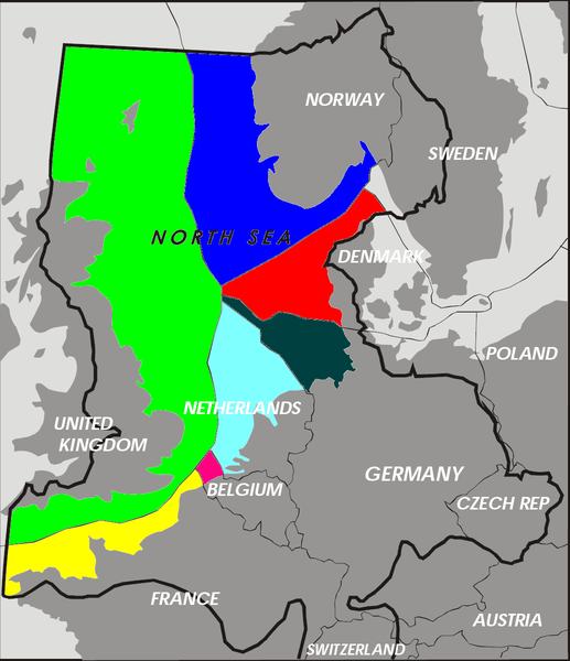
Flo looks two examples of the strange and important ways that geology and where it’s located can affect international governance and regulation. From the presence of tiny coralline islands to ownership of the Arctic!

I’ve always had an interest in the peculiarities of geology and geomorphology and the inordinate (sometimes almost absurd!) ways that they play their part in deciding on big international governance. Humanity has long-relied on the presence of geological features such as mountain ranges, coasts, rivers etc. to delineate ownership and basis on which to set ‘ground rules’.These geological features account for many historic and modern day national borders and so the odd rock in the right place at the right time can be very handy (or not, depending on which side of the coin you’re on…).  Sometimes this works well, countries such as India and Chile use enormous, previously impassable mountain ranges such as the Himalayas and the Andes as their natural borders and this has worked relatively well. Island states such as the UK assume their land borders at the point where land meets the sea, which also works for now but is ultimately just a function of current sea level. But in a dynamic world, the formation and loss of landmass and particularly changing sea levels will be shifting quite considerably in the face of human-induced climate change, and so the previously established rules and regulations about ownership and governance may start to become and bit less solid than it was…so where does this leave us?

I’m going to look at a couple examples of where geological features have influenced the distribution of governance responsibility among nations, and just how flimsy that burden of proof can get!

The Arctic

2007_Arctic_Sea_Ice - Copy (2)

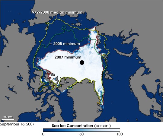
The image shows a record sea ice minimum in the Arctic, taken in September 2007. Image Credit – NASA, Wikimedia Commons.

One great example of how small, uncontrollable things can influence major decisions and changes, is the right to ownership and governance of the Arctic. The ongoing in reduction of sea ice in the Arctic due to climate change and recent developments in technology that would allow development of Arctic resources has led to something of an arms race with countries laying claim to large tracts of the region. The scientific basis for many of these claims is based on the mapping of ocean ridges and where they sit in relation to the Arctic states (Canada, US, Russia, Denmark, Finland, Iceland, Norway and Sweden).

The process for assigning areas of the Arctic is both scientific and political but nation states must prove through surveying that there is continuity and that they are geologically ‘attached’ to the Arctic by a ridge. The most recently lodged claim is that of Denmark, who, via Greenland a semi-autonomous Danish territory (another potentially fortuitous link in this chain), can lay claim to an area of 895,000 square kilometers due to the extension of the

Bathymetric map of the Arctic Ocean. Image Credit - NOAA, Wikimedia Commons.

Bathymetric map of the Arctic Ocean. Image Credit – NOAA, Wikimedia Commons.

Lomonosov ridge, according to a senior geophysicist with the Geological Survey of Denmark and Greenland. Denmark has filed a claim to the area to the UN linked to the ridge, and if successful will have access to a sizable chunk of the Arctic’s resources. The regulation that covers these kind of claims is the U.N. Convention on the Law of the Sea which states that nations are entitled to a distance of 200 nautical miles from their coast, any claims beyond this reach need to be supported by scientific data. This most recent claim is the fifth from Denmark who have also previously submitted claims north of the Faroe Islands (another Danish territory) and in an area south of the Faroe Islands. This builds on a body of work where Danish scientists surveyed a 2000 kilometer long underwater mountain range that runs north of Siberia, they concluded that this ridge is geologically attached to Greenland. All of the submissions await consideration by the Commission on the Limits of the Continental Shelf , the Danish statement currently overlaps with with Norway’s continental shelf beyond 200

A USSR postcard depicting Soviet dominance of the Arctic! Image Credit - kristofer.b, Wikimedia Commons.

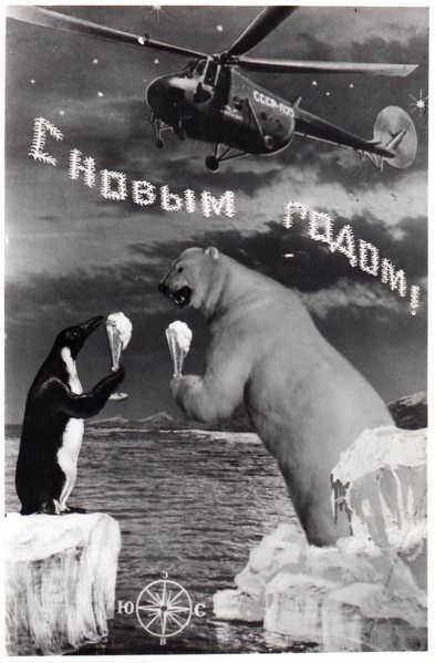
A USSR postcard depicting Soviet dominance of the Arctic! Image Credit – kristofer.b, Wikimedia Commons.

nautical miles and there are also potential overlaps with claims by Canada, Russia and the U.S.

Some people involved in the process had hoped that control of the Arctic would be decided on through a ‘Gentleman’s agreement’ rather than the tough negotiations that will now ensue.

The United Nations panel will eventually decide control of the area, and the sea floor boundaries will be settled by international negotiations but this process won’t begin until the  scientific data has been examined. This is expected to take 10-15 years, by which stage the politics around accessible resources in the Arctic will have intensifed due to increased global warming creating easier access to many of the oil and mineral reserves, so this topic isn’t going away!

Okinotori Islands

This tiny uninhabited set of islands, 1100 miles south of Tokyo in the Phillippine Sea is currently also responsible for lending control of a 160,000-square-mile economic zone in the surrounding waters. The most southerly of Japan’s landmass is only 7 miles around and it is just, and only just, keeping its head above water. Herein lies the problem, according the the UN’s ‘Law of the Sea’ ( useful but problematic bit of regulation), any claim to an exclusive economic zone, (such as Okinotorishima, or ‘distant bird island’) like the one in Japan is

Location of the Okinotorishima islands in the Phillippine Sea. Image Credit - ForestFarmer, Wikimedia Commons.

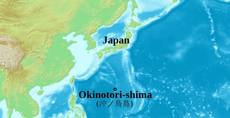
Location of the Okinotorishima islands in the Phillippine Sea. Image Credit – ForestFarmer, Wikimedia Commons.

dependent on the existence of a habitable island landmass existing in the area. If this island sinks beneath the water then the whole claim to the economic zone sinks with it, along with important mineral and fish resources for Japan. The claim, even if the islands stay above water isn’t uncontested, China disputes the ownership stating that  the islands are just a cluster of uninhabitable rocks and doesn’t fulfill the requirement of ‘habitable’ at all! While it’s true that no one lives there, the small area is host to a small man-made islet with a platform which is used as a weather monitoring station with a building that houses researchers.

The usefulness (and contention) of these islands and their slow sinking has not bypassed the Japanese government who have set up programs (and considerable investment) to keep the islands bobbing above sea level. The project to keep the island above water is two-fold, the Japanese government have installed protection around the island in the form of  cement, steel blocks and titanium mesh to protect from erosion and the increasing number of tropical storms.

800px-Okinotorishima2

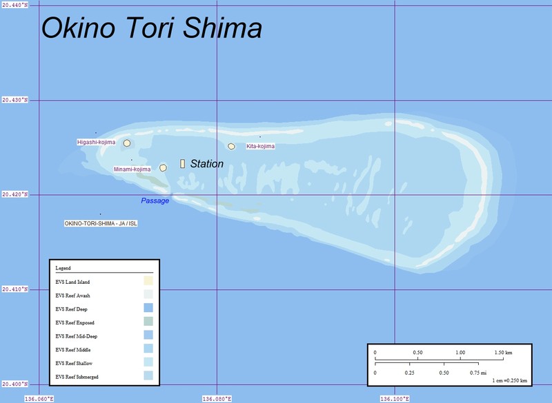
Map of Okino-Torishima, Pacific Ocean. Image credit – Ratzer, Wikimedia Commons.

However the ‘sinking’ is not just due to erosion and damage but also due to the low production of coral.  This is thought to be due to the warmer waters in the area lowering coral growth.  This loss of landmass and the important politics associated with it has meant that several agencies have made it a priority to revitalise the growth of  corals, although it’s not quite that simple! This involves applying a method of sexual reproduction developed over the past 20 years to cultivate corals. According to the fisheries agency, about $19 million ( of tax payers money…) has been spent to breed about 100,000 coral plants using the method with a success rate of approximately 20%. It remains to be seen whether this rock, doctored or otherwise, will be in the right place for the Japanese authorities in years to come…..

It’s worth reflecting that with both these examples, not only are they wholly reliant on the location of bits of geology to define long-lasting rules, regulations and potentially economic opportinities that can make or break countries but also these rocks (in a geological sense) are totally transient, and the ridges that secure the Arctic and the corals that secure the economic zone for Japan just happened to be in the right place at the right time. Throw in an exntending ridge of a destructive plate margin somewhere else and this fragile hierarchy would be thrown into disarray.

Further Reading

BBC News – Denmark challenges Russia and Canada over North Pole.

Phys.Org – Denmark claims North Pole link via Greenland ridge link

NPR.org – Denmark Claims Part Of The Arctic, Including The North Pole

Global News – Denmark claims North Pole through Arctic underwater ridge link from Greenland

New York Times –Growing Coral to Keep a Sea Claim Above Water

You Tube – China refutes Japanese claim about Okinotori Reef as island

Asia-Pacific Journal – Japan Focus – The US-Japan-China Mistrust Spiral and Okinotorishima


Geology and the Autumn Statement

Geology and the Autumn Statement

So George Osborne donned the ceremonial red briefcase on wednesday and took to the helm in the House of Commons (rather inconsiderately while I was in Brussels and couldn’t follow the news…) to deliver the Autumn Statement, one of the two statements that the HM Treasury makes each year to Parliament upon publication of economic forecasts (the other being the Budget which is normally announced in March-time).

George Osborne and Danny Alexande make their way to the House of Commons for the Autumn Statement Announcement. Source - Getty UK

George Osborne and Danny Alexander make their way to the House of Commons for the Autumn Statement Announcement. Source – Getty UK

Statements in the run up to wednesday suggested that Science and Engineering were likely to be singled out as the Chancellor’s ‘personal priority.  In amongst all this were some announcements which relate directly to geology and in particular, Energy.

1 – North Sea Oil and Gas

The government announced plans to help maximise the economic benefits of the oil and gas resources in the UK Continental Shelf (UKCS). They estimate there is between 11-31 billion barrels still to be exploited and argue that it can provide considerable eonomic benefits to the UK through much sought energy security, high-value jobs and other things. These plans include setting out major reforms to the oil and gas fiscal regime which include a 2% reduction in the rate of the Supplementary Charge from 32-30%.

See 1.124 and 1.125 in the ‘Green Book‘ for more details.

2 – Investment fund for Shale Gas

The UK government has long championed shale gas development as a tool to increase the UK’s energy security, create new jobs and create tax revenue. As part of the government’s ongoing progress in shale gas development, the Autumn Statement detailed a new ‘£5 million fund to provide independent evidence directly to the public about the robustness of the existing regulatory regime’. The reasoning for this is that it will ensure the public is better engaged in the regulatory process.

See section 1.121 in the ‘Green Book‘ for more details.

3 – Funding for sub-surface testing facilities

An interesting inclusion is a £31 million fund for investment into creating so-called ‘sub-surface research test centres’ through the Natural Environment Research Council (NERC). These will be designed to develop world leading knowledge of energy technologies such as shale gas and carbon capture and storage.

See section 1.122 in the ‘Green Book‘ for more details.

4 – Move towards developing the Swansea Bay Tidal Lagoon

As part of the governments commitments to decarbonisation targets they have announced plans for ‘closer discussions’ with the company managing the project at Swansea Bay, Tidal Lagoon Power Ltd to establish whether a tidal lagoon project is affordable and value-for-money for consumers. If this project were to progress it could become the first tidal lagoon project in the world.

For more information on the proposed tidal lagoon project see this story on the BBC News Website and see 1.129 in the ‘Green Book‘.

Swansea Bay where the new Tidal Lagoon would be located. Source - Kakoui, Wikimedia Commons.

Swansea Bay where the new Tidal Lagoon would be located. Source – Kakoui, Wikimedia Commons.

5 – Postgraduate Funding

And lastly there was a pretty important note about Postgraduate Taught Masters funding. The geological community has been dismayed at the lack of funding for postgraduate taught masters for sometime in particular becuase many of the Taught Masters Programs (such as Petroleums Geophysics and Hydrogeology) are seen as essential for careers in these areas. The lack of any funding framework for such courses, and the reduction in Industrial funding and scholarships has put real pressure on students wanting to pursue careers in this highly technical area. The government announced in the Autumn Statement that it will introduce a postgraduate loans system offering £10,000 to students under 30 (bit mean!) from 2016-2017. A consultation to inform the design of the scheme is set to follow early next year.

For more information on this announcement see this piece in the Times Higher Education webpage.


What’s geology got to do with it? 5 – Scottish Independence Referendum

What’s geology got to do with it? 5 – Scottish Independence Referendum

Flo summarises 5 geo-relevant policy issues that are likely to impact on the Scottish Independence Referendum.

Sooooo apologies for the long blog holiday we’ve been on of late, Marion and I have had a fairly hectic summer, but fear not, we will be updating on a more regular basis from now on!

800px-Scottish_Flag

Source – Wikimedia Commons, Credit: Smooth_O.

Hitting the headlines in the UK this week is the impending referendum for Scottish Independence taking place on the 18th September. Latest polling suggests that the vote outcome is on a knife-edge. Either way, the build-up and inevitable political wrangling after the result undoubtedly means that the situation has changed for everyone, regardless of the outcome. One thing is for sure: the implications of an independent Scotland means big changes for both countries, the shape of which is still little understood and requires much discussion in the negotiation stages.

Taking a sidestep from the core politics for the moment, I’m going to have a brief look at 5 geology related topics in the run up to the referendum that could be affected, for better or worse depending on your point of view, by the decisions made next week!

This topic, like others with a geopolitical element, tells another interesting story about the link between the fortuitous geo-location of resources and the creation of nation states.

Fossil Fuel Reserves: The North Sea and Shale Gas

North Sea Licence

Exclusive economic zones for the North Sea, the green refers to the area covered by the UK Continental Shelf. Source – Wikimedia Commons, Credit: Inwind.

North Sea oil and gas has formed a significant proportion of revenue for the UK since the mid 60’s when the UK Continental Shelf Act came into force. Since then the UK government, via the UK continental shelf economic region, has controlled licensing of hydrocarbon extraction. This has been a particularly crucial source of revenue for the UK which peaked in 1999 with production of 950,000m3 (6 million barrels a day). In an independent Scotland, income from the remaining hydrocarbons in the North Sea would provide a considerable amount of revenue, but the rights over the North Sea, in the event of an independent Scotland are unclear, as it is yet to be negotiated. The majority of the confusion over this issue arises from the line in the North Sea that would demarcate Scottish territory. Many agree that this is likely to be drawn along the ‘median line’ or ‘equidistance principle’: a ‘line between the nearest points of land on either side using the baselines established around the coast of the UK in accordance with international law’ (from the UK Government’s Scotland Analysis: Borders and Citizenship). On this basis, Scotland’s share of the North Sea would be somewhere between 73-95% according to different sources. Further complications lie in the debate over the estimates of reserve remaining and whether it is more difficult to extract (geologists will be more than familiar with this sort of uncertainty!!).

North Sea oil and gas fields distribution. Source - Wikimedia Commons.

North Sea oil and gas fields distribution. Source – Wikimedia Commons, Credit: Gautier, D.L .

A fact check produced by Channel 4 earlier this year cast doubt on the values of remaining reserves. These unknowns have made confident and informed arguments on this topic difficult for both sides. This may not be critical, however, as leaving the North Sea out of the Scottish economy completely, it is still a thriving economy: only slightly smaller than that of the UK.

Another issue that has been discussed in the run up to the Scottish independence referendum is Scotland’s shale gas reserves and the issue of fracking. A report published just last week by the N56 business body claimed that fracking of what would be Scotland’s oil and gas reserves could almost double the amount recoverable from oil and gas in the North Sea, the target being the Kimmeridge Bay formation, an Upper Jurassic organic rich shale which is the major oil and gas source rock for the Central and Northern North Sea. The BGS has since debunked this estimate stating that there is only “a modest amount” of shale gas and oil reserves

There is a more detailed discussion of these issues on Carbon Brief’s blog

Climate Change and Renewable Energy

Wether_Hill_wind_farm_-_geograph.org.uk_-_414459

Wether Hill, Dumfries and Galloway wind farm. Source – Wikimedia Commons, Credit: Walter Baxter.

Scotland has some pretty impressive environmental credentials when it comes to renewable energy, a staggering 69% of Scotland’s electricity was generated from a combination of renewables (29.8%) and nuclear (34.4%) in 2012. Scotland has a massive renewable resource and the Scottish National Party (SNP) have been vocal in stating that they want to make Scotland the green capital of Europe. The Yes campaign website states that ‘Scotland is on target to meet all of its electricity needs, and 11% of its heat requirements, from renewable sources such as wind, wave, tidal, solar and biomass by 2020′. As it stands, control over energy policy and funding resides with Westminster. The Scottish Government has shown a commitment to low-carbon energy sources in its 2009 paper which introduced ambitious plans to reduce emissions by at least 80% by 2050.

Carbon Capture and Storage

798px-Peterhead_Power_Station_from_Boddam

Peterhead Power Station, Site of DECC CCS funding. Source – Wikimedia Commons, Credit: PortHenry.

After some very slow progress in the DECC CCS competition (see my earlier post on this), the shortlist (not even the final selection) was eventually announced last year with two shortlisted sites, one of which is the Peterhead Project off the coast of Aberdeenshire, which has been awarded a funded contract to undertake front-end engineering and design studies. The Peterhead Project may well have an uncertain future if the referendum turns out a ‘Yes’ result. Energy Secretary Ed Davey admitted that the progress of the Peterhead CCS plant would be significantly trickier in the event of independence. While the Yes campaign has outlined its low-carbon credentials, a future Independent Scotland may find it hard to justify funding the very expensive CCS scheme alone. We could, however, end up in a situation where rUK (rest of the UK – the successor state in the event of Scottish independence) projects send their CO2 to storage sites in the North Sea, the revenues of which would go to an independent Scotland. This would mean that Scotland could still benefit from CCS development even if development at Peterhead is cancelled.

Research and Science Funding

OLYMPUS DIGITAL CAMERA

Grant Institute, School of Geosciences, Edinburgh University. Source – Wikimedia Commons, Credit: Kay Williams.

Much has been written about the future of science research and  funding in the event of a Yes vote at the referendum. Some groups of scientists have come out to say that a Yes for independence could damage the country’s research base and hurt the economy, this was stated most recently by the presidents of the Royal Society, the British Academy and the Academy of Medical Sciences. In contrast, the ‘Academics for Yes‘ group states that Scottish independence will secure and enhance the international profile of Scottish universities and also boost work between the research sector and the government to develop Scotland’s economy, as well as giving them control of research priorities. A piece posted just this week in Nature showed that opinion is split with regards to the impact of independence on science research and funding, with some touting improved innovation under independence and others saying that the border would hinder the open exchanges under which science thrives.

Radioactive Waste Disposal

800px-Dounreay_Nuclear_Power_Development_Establishment_geograph-3484137-by-Ben-Brooksbank (1)

Dounreay nuclear power development, Caithness. Source – Wikimedia Commons, Credit: Ben Brooksbank.

The Scottish Government’s energy policies, in contrast to Westminster, favour renewable energy as well as use of North Sea Oil and Gas over what is described as ‘risky’ nuclear power and their policies for radioactive waste disposal also differ from that of Westminster. While Scotland has stated that it won’t be developing new-nuclear power it has an extensive history of nuclear power generation which has its own legacy waste associated with it.  The Scottish Government, unlike the UK Government, has stated it will not use geological disposal as a method of waste storage and their policy is that waste should be stored in near-surface facilities and recognises that ‘long-term management options may not be feasible at present or have yet to be developed‘.  A recent academic paper on this issue suggested the following: 

‘In an independent or further devolved Scotland the task of building the necessary installations for nuclear waste disposal will be a significant cost to a new nation. However, there is also a lack of a legal framework, and this should be addressed with immediate effect.’

Additional confusion with regards to radioactive waste policy arises from the difference between ‘spent fuel’ and waste. Spent fuel is defined by the US Nuclear Regulatory Commission as:

the bundles of uranium pellets encased in metal rods that have been used to power a nuclear reactor. Nuclear fuel loses efficiency over time and periodically, about 1/3 of the fuel assemblies in a reactor must be replaced. The nuclear reaction is stopped before the spent fuel is removed. But spent fuel still produces a lot of radiation and heat that must be managed to protect workers, the environment and the public.

Spent fuel is not currently classified as waste, and therefore can be traded and sent overseas for processing, whereas this is banned for material classified as ‘waste’. Currently, the Thorp Reprocessing plant at Sellafield accepts spent fuel contracts from around the world (including Scotland), that would include an independent Scotland. However, the Thorp plant is due to close in 2018 when current contracts have been completed. This may create an issue with any remaining spent fuel in the UK, regardless of an independent Scotland. However, if either an independent Scotland or the remaining UK decided to reclassify ‘spent fuel’ as waste, this would remove the option to export waste for processing and would require an independent Scotland to develop additional infrastructure to deal with this new waste.

Further Reading

What’s geology got to do with it? 4 – Tennis!

What’s geology got to do with it? 4 – Tennis!

 As part of the ‘What’s geology got to do with it?’ series, Flo takes us on a tour of the links between geology and tennis! Warning: You may not want to read this if you have no interest in Geology OR tennis…. 

Now the disclaimer’s out of the way, I thought it was about time I married two of my greatest loves in life, Geology and Tennis. These two interests may seem completely at odds in terms of relevance, but as is the beauty with geology, it relates to just about everything!

So, summer in the northern hemisphere and therefore the two biggest Grand Slams in tennis are upon us!  The French Open, the king of the clay-court season is currently underway and Wimbledon, the jewel (and one of the few remaning…) grass court tennis tournaments is just around the corner.

But for a sport containing so few tangible objects: a court, a racket, a person and a tennis ball, how does it relate to Geology? Well….

Tennis Courts

491px-ND_DN_2006FO

Court Philippe Chatrier Court at the French Open, the only Grand Slam played on red clay. Source – Wikimedia Commons

Professional tennis is  played on 3 types of court surface, each with its own season during the tennis calendar.  You have the hard court season, which dominates most of the year between July and February, beloved by Djokovic, then you have the European and North and South American clay court season from February to May, favourite of clay-court extroadinaire Rafa Nadal and then the shortest season of all, the grass court season, occupying all of 4 weeks in the summer, from June-July, once dominated by Federer and recently by Murray! The most obvious link to geology here is the clay courts, so how do you go about building a clay court and what materials do you need?

Red Clay Courts

Well first of all, very few clay courts are actually made of natural clay. This is because they can take a very long time to dry out (which you’ll know if you’ve ever done any pottery….). For this reason, the red clay courts as seen at the French Open and numerous other clay court tournaments are actually made from crushed brick or shale. Bricks are used because they absorb water less easily than natural clay and are produced from a mix made from Alumina (clay), sand, lime and iron oxide before being fired until dry.


guga-kuerten-trophy-frenchopen08

Guga Kuerten being awarded a cross-section of the court in his last match at the French Open in 2008. Source – Tennis Served Fresh Blog

So if you want to build a clay court like the famous red-clay courts of the French Open, first of all you need to lay a base layer, this is covered with a layer of crushed stones, this is then overlain by a layer of clinker. This is then followed by a layer of crushed limestone and finally, the crushed brick forms the thinnest layer at the top. A cross section of the layering under the court surface formed the trophy that former French Open champion Guga Kuerten received when he played his last match at the tournament in 2008!

800px-Drying_mud_with_120_degree_cracks,_Sicily

You wouldn’t want the Philippe Chatrier court looking like this after a few hours of sunshine! Source – Wikimedia Commons.

Maintenance of the court after completion is a bit tricky as the clay needs to be constantly smoothed and watered in order to prevent dewatering cracks, a feature that many geologists are very familiar with!

Green Clay Courts
800px-Maria_Sharapova,_2008_Family_Circle_Cup

Maria Sharapova playing on the ‘green clay’ at the Family Circle Cup. Source – Wikimedia Commons

Not all tournaments use red clay, so called ‘green’ clay’ or ‘Har-Tru’ has become very popular in the United States. Har-Tru courts are similar in construction but are made from crushed basalt rather than brick meaning they are slightly harder and faster. According to their website, Har-Tru courts are made from ‘billion-year old Pre-Cambrian metabasalt found in the Blue Ridge Mountains of Virginia‘. This rock has two important properties, which is that it is hard and angular which allows it to ‘lock together to form a stable playing surface’ and the hardness provides ‘exceptional durability’.

Tennis rackets

800px-Tennis_Racket_and_Balls

A modern tennis racket with a carbon fiber-reinforced polymer frame. Source – Wikipedia Commons

As with many manufactured items, the raw materials required to make them eventually leads us back to our natural resources in the ground. Earlier tennis rackets were always made from wood, with strings made from gut, but these days, advancements in materials technology means that the majority of professional frames are made from ‘high modulus graphite and/or carbon fibre while titanium and tungsten are often added to give the frame more stiffness and the strings are made from nylon (although Federer and Sampras are famous for using natural gut strings).

Supplies of pure titanium are rare although titanium ores such as ilmenite and rutile are much more common. Titanium is largely mined in the titanium-rich sands of Florida and Virginia as well as Russia, Japan, Kazakhstan and other nations. Much more rare is Tungsten, which has seen a rapid rise in price in recent years as supplies dwindle. Tungsten has recently emerged as a ‘critical’ metal with the majority of the world’s tungsten supply located in China. However Hemerdon mine  in Devon which has been closed since 1944, is thought to host one of the largest tungsten and tin deposits in the world, and is set to reopen under control of an Australian firm in the near future with permit plans progressing this year.

For more on how a tennis racket is made: http://www.madehow.com/Volume-3/Tennis-Racket.html

Tennis Balls

427px-Tennis_balls,_advertisement,_19th_century

Tennis ball advertisment, 19th century. Source – Wikimedia Commons

According to an article in the guardian published in 2013, manufacture of Slazenger tennis balls now has a 50,000 mile production journey before they end up in Centre Court at Wimbledon. Part of this journey includes the transport of various mineral resources. These include the transport of clay from the United States,  Petroleum Napthalene (derived from coal tar) from China, Sulphur from South Korea, Magnesium Carbonate from Japan, Silica from Greece and Zinc Oxide from Thailand. This exemplifies not just the truly global nature of the manufacturing markets but also the complex importing and exporting of many natural resources for something as simple as a tennis ball.

For more on how tennis balls are made, see the ITF website: http://www.itftennis.com/technical/balls/other/manufacture.aspx


Tennis Net

courtmaster-net

Anatomy of a tennis net. Source – Do it tennis website.

The majority of the different parts of a tennis net are made up from either polyester or polyethylene, both formed synthetically. However, the raw materials required to synthesise both materials  started off as extracted hydrocarbons. Polyester synthesis requires the polymerisation of ethylene which is derived from petroleum.

60 million tonnes of polyethylene is manufactured each year and is the world’s most important plastic. It is made by several methods by addition polymerisation of ethene, which is principally produced by the cracking of ethane and propane, naptha and gas oil, all hydrocarbon fractions. In Brazil, a plant is being constructed to make polyethylene from sugar cane via bioethanol.


And that’s how geology underpins everything we know and love about tennis!


For more information on the link between sports and geology, see the United States Geological Survey’s article on ‘Minerals in Sports: Tennis’: http://minerals.usgs.gov/minerals/pubs/general_interest/sport_mins/tennis.pdf