EGU Blogs

Flo Bullough

Flo is a Policy Assistant at The Geological Society with experience and interests in Water Geochemistry and Environmental Geoscience. She helps to promote the Environment Network & interdisciplinary approaches to geological problems and policy issues. Tweets as @flo_dem.

What’s Geology got to do with it? 2 – Coffee

We should start this post with a declaration of interest. We absolutely love coffee. Whether it’s  latte, macchiato, flat white (or cafe au lait for Marion!) we drink it everyday! So for our second installation of “What’s geology got to do with it?’ we’re going to highlight the connections between coffee and geology!

fpVcA2_imgur

Coop loves his coffee! Source

As well as being absolutely delicious (and often powering an entire community of researchers, PhD Students, lawyers etc through work on a daily basis!) coffee is the 2nd most traded commodity in the world, sitting in a list dominated by other commodities important to geoscience!

  1. Crude Oil
  2. Coffee
  3. Cotton
  4. Wheat
  5. Corn
  6. Sugar
  7. Silver
  8. Copper
  9. Gold
  10. Natural Gas

Coffee and Soils!

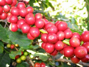
800px-CoffeeCatucai

Coffee berries, a variety of Coffeea Arabica. Source – Marcelo Corrêa, Wikimedia Commons.

In order to supply the international demand for coffee, coffee trees require a large supply of nutrients. These nutrients are delivered through soils which are ultimately formed from the breakdown and erosion of rocks. In addition to allowing coffee trees to grow, the soil makeup will also contribute to a coffee’s unique flavour profile. Having said that, the combination of factors affecting taste is so complex, that even from a single plantation you can find variation in quality and taste.

What does coffee need to grow?

Aside from cool-ish temperatures (~20 degrees) and high altitude (1000-2000 metres above sea level), Coffee requires a wide variety of essential elements in order to grow and deliver the delicious stuff we drink. These elements are delivered through the soil profile. The usual suspects like Phosphorus, nitrogen, potassium, calcium, zinc and boron are all very important. The level of potassium influences total sugar and citric acid content while nitrogen is important for amino acid and protein buildup and can influence caffeine build up. Boron is important for cell division, cell walls and involved in several enzyme activities. It also influences flowering and fruit set and affects the yield. In addition to soil type and content, factors such as slope angle (15% is optimal), water supply (good supply with interspersed dry periods are essential) and altitude exert strong influence on the success of coffee growth.

What soils are best?

Coffee can be grown on lots of soils but the ideal types are fertile volcanic red earth or deep sandy loam. For coffee trees to grow it is important that the soil is well draining which makes heavy clay or heavy sandy soils inadequate. Some of the most longstanding and famous coffees are grown on the slopes of volcanoes or in volcanic soil, also known as ‘Andisols’.

Definition of Andisol (USDA soil taxonomy) – ‘Andisols are soils formed in volcanic ash and defined as soils containing high proportions of glass and amorphous colloidal materials, including allophane, imogolite and ferrihydrite.’
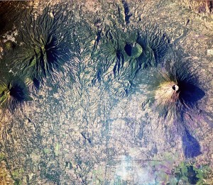
102 SSC2_No_Folder _33R

Coffee grows on the slopes of these volcanoes in El Salvador. Source – NASA, Wikimedia Commons

But why are they so fertile? This is due to how young, or immature they are as soils. They still retain many of the elements that were present during the formation of the rock, they haven’t been plundered over hundreds of years of agriculture, they haven’t undergone extensive leaching and are relatively unweathered. This means they often include basic cations such as Mg, Ca or K (which can be easily leached out) and often retain a healthy supply of trace elements. Whilst these soils are very fertile, they only cover around 1% of the ice-free surface area of the earth. They can usually support intensive use for growing coffee and other mass crops such as maize, tea and tobacco. Despite the high fertility of volcanic soils, many do need a nutrient top-up during the growth cycle that comes from natural manure or fertilisers, which are themselves in diminishing supply.

Volcanic soils also have a good structure and texture for coffee growth as they often contain vesicles, which makes them porous and ideal for retaining water. Shallow groundwater is bad for coffee growing as it can rot the roots and it needs to be at least 3 metres deep. Roots of coffee have a high oxygen demand so good drainage is essential.

Where does coffee grow and why?

It is no surpise then that some of the most famous and historic coffee growing regions are in areas of past and current volcanic activity such as Central America, Hawaii and Indonesia. Coffee trees produce their best beans when grown at high altitudes in a tropical climate where there is rich soil. Such conditions are found around the world in locations along the Equatorial zone.
Coffee is grown in more than 50 countries around the world including the following;

  • Hawaii – coffee is grown in volcanic soil or directly in the loosened rock. The location and island climate provides good growing conditions. 
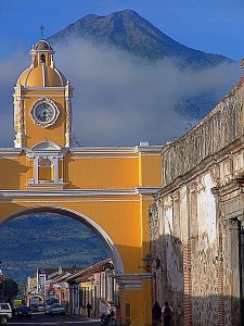
    GT056-Antigua_Arch-low.jpeg

    Volcán de Agua overlooking Antigua in Guatemala an area with a big coffee production industry. Source – Zack Clark, Wikimedia Commons.

  • Indonesia – coffee production began with the Dutch colonialists and the highland plateau between the volcanoes of Batukaru and Agung is the main coffee growing area. Ash from these volcanoes has created especially fertile andisols.
  • Colombia – thought that Jesuits first brought coffee seeds to South America. One of the biggest producers in the world, regional climate change associated with global warming has caused Colombian coffee production to decline since 2006. Much of the coffee is grown in the cordilleras (mountain ranges).
  • Ethiopia – grown in high mountain ranges in cloud forests.
  • Central America – rich soils along the volcanic range through central america, equatorial temperatures and mountainous growing areas make this a powerhouse in the coffee growing world. 

Coffee and Climate!

Like many crops and food commodities, good coffee requires good climate. For our favorite bean, this typically means temperate regions  at altitudes of 1000-2000 m. But climate is changing and this is likely to have a big impact on coffee growth, and by association, on the livelihood of millions of local coffee farmers who rely on its production.

In its latest report out last month, the UN’s Intergovernmental Panel on Climate Change (IPCC, the leading  body assessing climate change impacts) confirmed for the 5th time what climate scientists worldwide already know: that our climate is warming as a result of human activities. Global temperatures have already risen by almost 1C since the end of the 19th century and will continue to rise at even faster rates over the coming century.

There are two ways in which a changing climate will impact coffee growth and production.

First, increasing temperatures or changes in precipitation will directly affect the areas suitable for coffee growth, leading to a loss in coffee growing environments.
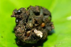
A coffee berry being chewed up by hungry Hypothenemus hampei - Source: L. Shyamal, Wikimedia Commons.

A coffee berry being chewed up by hungry Hypothenemus hampei – Source: L. Shyamal, Wikimedia Commons.

Second, and perhaps most importantly, changing climate and higher temperatures will affect a little insect called Hypothenemus hampei (H. hampei for short). H. hampei is small but lethal. This beetle-like insect is what people call a coffee berry borer. It is the most important threat to coffee plantations worldwide.

Born in central Africa, H. hampei began colonising coffee plantations worldwide with the global movement and commerce of coffee beans. H. hampei likes warm climates. Until about a decade ago, it was very happy munching away at low-altitude beans, below the preferred altitude of our beloved Arabica coffee (between 1200-2000 m in East Africa).

But with rising temperatures, the berry borer can now survive at higher altitudes. On the slopes of Mt Kilimanjaro in Tanzania, H. hampei has climbed 300 m in 10 years.
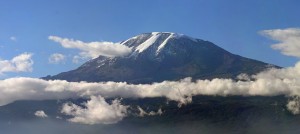
Mount Kilimanjaro - Source: Muhammad Mahdi Karim, Wikimedia Commons.

Mount Kilimanjaro – Source: Muhammad Mahdi Karim, Wikimedia Commons.

H. hampei causes over $500 million loss annually in East Africa alone. The borer is gaining both geographical extent (it is only absent from coffee plantations in China and Nepal, having infiltrated Puerto Rico in 2007 and Hawaii in 2010) and altitude. A further 1C increase will see the borer develop faster and gain new territories.
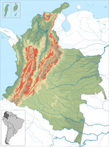
The Colombia coffee belt - Source:  Instituto Geografico Agustin Codazzi, Wikimedia Commons.

The Colombia coffee belt – Source: Instituto Geografico Agustin Codazzi, Wikimedia Commons.

In Colombia, where coffee accounts for 17% of the total value of crop production, temperatures in the coffee belt region are projected to rise by 2.2C by 2050. This could both shorten the coffee growing season and allow  the pest to make its way above 1500 m.

It has been estimated that Colombian plantations would have to be moved up by 167 m for every degree of warming.

In East Africa, studies predict that Arabica coffee, currently grown at 1400-1600 m,  will have to shift to 1600-1800 m by 2050 as a result of rising temperatures.

But it is unlikely that East African coffee plantations will be able to adapt. For one, suitable high altitude habitats are not common. Second, population growth is likely to put a huge demographic pressure on arable land (the population in Ethiopia is set to double by 2050 – see this fact sheet by the Population Reference Bureau) and it is likely that the shrinking available arable land will be used to cultivate other crops over coffee.

The impact of climate change on invasive pest species is something that ecologists are studying worldwide. Small changes in average temperatures can have huge bearings on where these pests live and what they feed on, and this seems to already be the case for the coffee berry borer.

Let’s hope Flo and I can continue enjoying our weekly Four Degrees coffee meetings for many years to come!

Flo and Marion


Momentous Discoveries in Geology – The World of Nano!

Momentous Discoveries in Geology – The World of Nano!

I first came across the intriguing world of nanoparticles when I saw an awe-inspiring talk by nano-extraordinaire Professor Michael Hochella from Virginia Tech at the Geological Society. He wove a fascinating tale about the world at nanoscale, the special properties, the infinite uses and the potential environmental impacts as well as outlining the need for caution, scrutiny and intensive research from the scientific community in the wake of an exploding nanotechnology industry. I’ve decided to re-visit the area of nanoscience for the ‘Momentous Discoveries in Geology’ blog festival.

What’s so special about Nanoparticles?

Solutions of gold nanoparticles of various sizes. The size difference causes the difference in colors.

Solutions of gold nanoparticles of various sizes. The size difference causes the difference in colors. Source – Aleksander Kondinski, Wikimedia Commons.

Nanoparticles refer to particles between 1 and 100 nanometers in size and can be found in nature, inadvertently produced by humans or most recently, manufactured as part of the boom in nanotechnology. Their geo-relevance comes from both their behaviour in nature and potential nanotoxicity but also in their manufacture for engineering processes such as environmental tracers and remediation materials. Nanoparticles are unique and special in their physical properties, which can vary greatly from macro-scale properties. Nanotechnology exploits these unusual properties to improve the efficiency and sustainability of already existing processes. They are highly mobile, have enormous specific surface areas, unexpected optical properties and can exhibit what are known as quantum effects. An example being: superparamagnetism (magnetization that can randomly flip direction under the influence of temperature) a characteristic found in ferromagnetic materials smaller than 10nm. Nanoparticles can also have unusual optical properties: gold nanoparticles for example appear deep red to black in solution, depending on their size. They also melt at much lower temperatures (~300 °C for 2.5 nm size) than gold slabs (1064 °C). Their first known use for their colour-changing properties was back in roman times (30BC – 640AD), using gold nanoparticles, which were impregnated into the glass of

The Lycurgus Cup - a 4th-century Roman glass cage cup , which shows a different colour depending on whether or not light is passing through it; red when lit from behind and green when lit from in front due to the incorporation of nanoparticles - You can go and see it in the British Museum!

The Lycurgus Cup – a 4th-century Roman glass cage cup , which shows a different colour depending on whether or not light is passing through it; red when lit from behind and green when lit from in front due to the incorporation of nanoparticles – You can go and see it in the British Museum! Source – Johnbod, Wikimedia Commons.

goblets to give a colour change from green to blood red when lit from behind. The requirement of the exact mixture of sizes to manifest this effect suggested that the Romans knew what they were doing!

Early history of nanoparticles

The discovery of nanoparticles has not so much happened as a single momentous discovery but as a series of moments over a ~100 year period. As with many discoveries, they are as a result of breakthroughs in instrumentation and technology which breakdown the barrier to discovery. In addition to the early use in roman times, nanoparticles were also used in the medieval (500-1450AD) and renaissance (1450-1600 AD) periods, again for their colour-changing properties for use in stained glass windows in medieval times and for colouring ceramics during the renaissance. The deep reds you see are caused by the incorporation of gold nanoparticles in the glass and the deep yellows are caused by silver nanoparticles. We also see this effect used in Ceramics. In the Islamic world, where the incorporation of gold in artistic representations was not allowed, the solution was using dense nanoparticulated layers of glaze to generate a golden metallic shine.  This colour changing capacity is caused by the size of the materials that are incorporated. Photography is also an early example of nanotechnology which is reliant on the production of silvernanoparticles that are sensitive to light.

When were they discovered?

220px-Faraday-Millikan-Gale-1913

Michael Faraday – 1861. He first described the optical properties of gold nanoparticles in his classic 1857 paper. Source – Wikimedia Commons.

The earliest and most significant breakthrough came during Michael Faraday’s pioneering experiments and his seminal paper in 1857 where he described the optical properties of nanometer-scale metals for the first time. He prepared the first metallic colloids (fine particles that suspend in solution, in between dissolved and settling particles, size range between 2-500 nm). He saw that they had special electronic and optical properties and stated – “It is well known that when thin leaves of gold or silver are mounted upon glass and heated to a temperature which is well below a red heat (~500 °C), a remarkable change of properties takes place, whereby the continuity of the metallic film is destroyed. The result is that white light is now freely transmitted, reflection is correspondingly diminished, while the electrical resistivity is enormously increased.”.

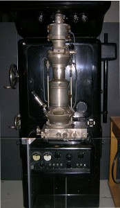
348px-Ernst_Ruska_Electron_Microscope_-_Deutsches_Museum_-_Munich-edit

First Electron Microscope with resolving power higher than that of a light Microscope designed by Ernst Ruska in 1931 with a magnification of around 12,000 times. Source – J Brew, Wikimedia Commons

While the unusual and fascinating properties of nanoparticles had been described, they were still too small to be seen and it took another 84 long years before electrical engineer Max Knott and physicist Ernst Ruska constructed the prototype electron microscope in 1931. This breakthrough put a spotlight on the “small world” and was an important step in allowing research at the nanoscale. This was followed by Erwin Mueller’s field-ion microscope which allowed the viewer, for the first time in history to observe individual atoms and their arrangement on a surface. This was a landmark invention allowing magnification of more than 2 million times. These technological developments formed the foundation for many other nano breakthroughs to come such as the ‘tunneling phenomenon’, the development of the field of molecular electronics, the development of Surface Enhanced Raman Spectroscopy (SERS), instrumental in the field of nanotechnology, the buckyball, quantum dots (which have implications for how solar energy is collected) and carbon nanotubes.


_____________________________________________________________________

This post is for a geoscience blog carnival called The Accretionary Wedge, which is being hosted by Matt Herod and you can see the call for posts here.

What’s all the Phos about?

What’s all the Phos about?

Phosphate use for fertilisers, essential in modern agriculture, is hitting an all time high while resources are being heavily depleted. Flo discusses the background, numbers, geopolitics and potential solutions behind the issue of ‘the end of phosphorus’.

The Issue

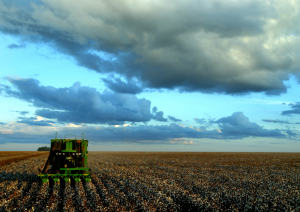
800px-Agriculture_in_Brazil

Modern agriculture has developed in-line with the availability of high quality phosphate-rock fertilisers. Source – João Felipe C.S, Wikimedia Commons.

The dilemma over diminishing natural resources is a topic of our times with the daily bulletins filled with reports related to resource shortages. These mainly focus around water, energy and food which are imperative for human survival. Whilst energy and water are often debated in the media and political chamber, an area that gets much less attention is agriculture, and in particular diminishing phosphate resources used for industrial fertiliser. Modern agriculture, particularly in developed countries has used mined phosphate for fertilisers for decades but this finite resource is being depleted at an alarming rate.

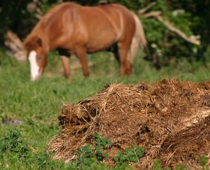
A combination of growing population, aspirational lifestyles and the demand for phosphate-intensive meat and crops has caused the rapid reduction of phosphate rock resources. In the past, prior to the advent of phosphate mining, additional phosphate for farming and agriculture was sourced from manures

Prior to use of phosphate rock, it was replenished through the use of manure.

Prior to use of phosphate rock, it was replenished through the use of manure. Source – Malene Thysson, Wikimedia Commons.

and organic waste, but as agriculture intensified, the hunt for easier, more accessible phosphate began. From the mid-20th century onwards, the use of rock phosphate was used as a high quality, easily accessible sources of phosphorus which gave rise to the modern fertiliser industry as we see it today. Farmers in rich countries such as Europe and North America became hooked on the cheap and easy phosphorus which readjusted agriculture practices and set phosphate demand through the roof.

Background

Phosphorus (P) is a non-metallic element which is almost always present in a maximally oxidised state (PO43-) as inorganic phosphate rocks due to its reactivity. Elemental phosphorus can exist as red and white (known for its use in weapons and artillery) phosphorus but almost never found as a free element in nature.

It is one of the building blocks of life and life simply wouldn’t exist without it.  It is a key component of DNA, RNA, ATP and phospholipids and is essential to cell development, reproduction and in animals, bone development. The use of phosphorus compounds in fertilisers is due to the need to replace the phosphorus that plants remove from the soil.There is no substitute for this element. Supplies are limited and much is currently wasted, creating concerns about future supplies in the EU and worldwide.

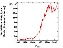
Peak Phosphorus?

220px-WorldPhosphateProduction

A graph of world phosphate rock production vs. year from 1900-2009 obtained from the U.S. Geological Survey. Source – Thomas D. Kelly and Grecia R. Matos, Wikimedia Commons.

Recently there has been a proliferation of articles and discussion over the potential for ‘peak phosphorus’ in the next 20-30 years. World production recently peaked at <160 million metric tonnes (mmt) in 2008. Whilst the majority of people agree that phosphorus is a resource that is of concern, not everyone agrees with the peak phosphorus hypothesis or its potential timing.  Proponents of the argument include this group of academics who published a paper entitled ‘The story of phosphorus: Global food security and food for thought’ and Jeremy Grantham, co-founder of the investment firm Grantham, Mayo, Van Otterloo, who recently wrote a piece in Nature. On mined-phosphate fertilisers, Jeremy Grantham stated that ‘There seems to be only one conclusion: their use must be drastically reduced in the next 20–40 years or we will begin to starve’. Much of the peak phosphorus argument comes from a widely produced diagram from a 2009  paper in Global Environmental Change depicting peak phosphorus to be around 2030 followed by production declining at an accelerating rate.  Detractors to this theory say that the markets are likely to adjust to this problem and cause the price to rise thus forcing a reduction in use and a push for technology to advance to find new sources or recycle current phosphate use. The International Fertiliser Development Center (IFDC), through extensive data gathering state that there is “no indication that a “peak phosphorus” event will occur” in the next 20-25 years.

Resources and Geopolitics

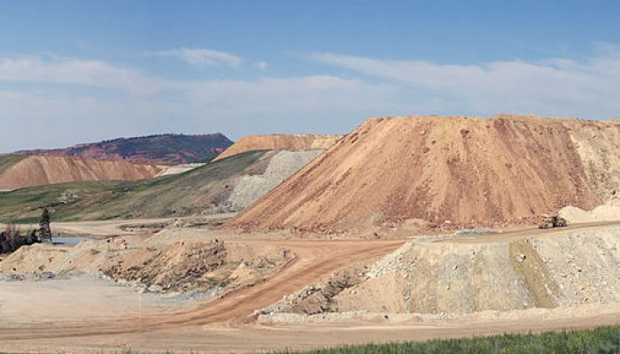
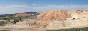
Phosphate_Mine_Panorama

Phosphate mine near Flaming Gorge, Utah. The large size of phosphate mines is dictated by the dispersed nature of phosphate in the rock. Source – Jason Parker-Burlingham, Wikimedia Commons.

Phosphate rock is typically mined at high volume due to its dispersed nature in the rock. Phosphate, in the mineral form of apatite in phosphate rock, is not bioavailable to plants and must be processed to convert it to a plant-available form. The concentrate is used to produce phosphoric acid which is then used in fertiliser products.  Phosphate rock can come in either a sedimentary or igneous form, with sedimentary making up >80% of total global production.

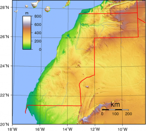
668px-Western_Sahara_Topography

Topographic map of Western Sahara. Western Sahara is disputed territory but is currently controlled by Morocco and therefore the Moroccan Royal Family. Source – Sadalmelik, Wikimedia Commons

In addition to the concern over the amount of resources and rate of use, also of concern is the location of much of the world’s supplies. Europe in particular has scant phosphate resources with a small amount in Finland.   According to the IFDC report from 2010, 72.1% of the world’s phosphate rock production was accounted for by China ( 31.5%), U.S.A (18.7%), Morocco and Western Sahara (15.5%) and Russia (6.4%). However a significant proportion of the world’s high-grade supplies are located in the disputed territory of Western Sahara in North-West Africa, currently controlled by Morocco. This has been termed by Jeremy Grantham  as ‘the most important quasi-monopoloy in economic history’.

Country Mine Production 2007
Mine Production 2008
Reserves Reserve Base (estimated)
China 45,700 50,000 4,100,000 10,000,000
Morocco and Western Sahara 27,000 28,000 5,700,000 21,000,000
Russia 11,000 11,000 200,000 1,000,000
United States 29,700 30,900 1,200,000 3,400,000
World Total (rounded) 156,000 167,000 15,000,000 47,000,000

Table adapted from USGS Mineral Commodity Summaries January 2009. Data is presented in thousand metric tonnes.

Phosphate rock resources in Western Sahara are extremely large and still incompletely explored and therefore it is not understood if the rock is producible at current prices and costs as there is little to no data. The IFDC estimates global resources of 290,000 mmt but if Morocco and Western Sahara resources are included (340,000 mmt) it may increase to 470,000 mmt, as seen in the above table.

Environmental Impacts

800px-EutrophicationEutrophisationEutrophierung

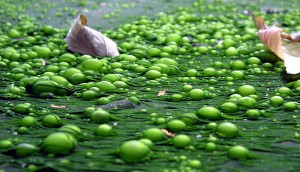
Eutrophication in a pond in Lille, France. Eutrophication is caused by the enrichment of an ecosystem with chemical nutrients such as phosphorus. Source – F. lamiot, Wikimedia Commons.

The use and mining of phosphorus also carries risks. In agricultural use not all of the phosphorus is absorbed by crops which results in leaching into the water. This causes the much discussed eutrophication effect causing algal blooms. Phosphorus mining is also difficult environmentally as it generates a large amount of the waste product phosphogypsum which contains both toxic heavy metals and low levels of radiation. This is very difficult to dispose of and often results in mounds of unprocessed waste material.

As lower-cost phosphate resources will be mined out, mining companies will utilise lower grade ores which will incur the use of more energy and water and will cause the price to go up. Availability of water is of high importance to mining operations and indeed this can dictate the feasibility of phosphate extraction, areas of low water availability may completely restrict development of the mine. Another way in which water, energy and food are interconnected.

What next?

800px-Discharge_pipe

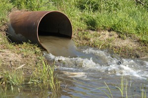
Wastewater discharge pipe – New studies show useable phosphorus can be recovered from wastewater. Source – Department of Agriculture, Wikimedia Commons.

Regardless of the proximity of ‘the end of phosphorus’ it is very much a finite resource and thus development towards more effective use and recycling needs to take place.  Recently, the Environment section of the EC launched a consultation into how to use phosphorus in a more sustainable way, following on from a conference held in March on Sustainable Phosphorus. They have also posted a series of informative videos that can be found here. Much work has been done on the ways in which we can curb our phosphate use or recycle it more effectively. More must be done to monitor and reduce phosphate use as well as recycle wasted phosphate. A few of the potential solutions are listed below.

Phosphate reduction

  • Changes in people’s daily diet away from phosphorus-intensive foodstuffs such as meat. 
  • Since much of phosphorus is lost from the food cycle through waste, a reduction of food waste and its reuse in composts etc could reduce demand.
  • Current agricultural practices result in a very high use of fertilisers. A switch to techniques and practices that conserve more soil nutrients would go some way to reduce phosphorus waste. This includes organic agriculture and use of permaculture (sustainable and self-sufficient agricultural practices).
  • Genetic engineering could produce plants that can flourish with much lower phosphorus use.

Recycling

  • We can recover useable phosphorus from waste streams including urban sewage, since current systems already remove phosphorus from sewage to preserve water quality. Wastewater carries a lot of struvite, a mixture of ammonium, magnesium and phosphate which builds up in the pipework.
  •  A team of canadian researchers believe struvite can be turned into environmental friendly fertiliser, as discussed in this national geographic article. Together with the local government they have set up a lab next to a waste water treatment plant. This process works by altering the pH and allows the wastewater chemical to bond together into pellets through a turbulence process. Currently a working prototype can turn out several tons of pellets a month. Since 2010, the technology has been incorporated into 5 waste water facilities in North America. Whilst there are some cost issues to address, there is relatively little further work required to reproduce this technology on a wide scale. Higher phosphate prices would push wastewater recovery to be economic. 

What’s Geology got to do with it? 1 – The Maya civilisation

What’s Geology got to do with it? 1 – The Maya civilisation

Geology is not just about looking at rocks. From finding oil and gas and tackling climate change to manufacturing, archaeology or geopolitics, geoscientists appear in most spheres of today’s world and economy, albeit often behind the scenes. In a new series of posts we will be looking at how geology relates to interdisciplinary or seemingly unconnected topics, which, at first glance, might seem like they have nothing to do with geology at all.

Earlier this year, Iain Duncan Smith (UK Work and Pensions Secretary) had a well publicised clash with geologists after saying in an interview on the Andrew Marr show regarding the legal battle of Cait Reilly – “The next time they go into their supermarket, they should ask themselves this simple question, when they can’t find the food they want on the shelves – who is more important – the geologist, or the person who stacked the shelves?” (see this excellent press release from the Geological Society in response). In way of response to this comment, this series will focus on the links between geology and the wider world and the importance of approaching problems from an interdisciplinary perspective. We hope to highlight the extensive reach of geology and how it can enrich our understanding of topics far outside of the traditional subject area.

1. The Maya civilisation

For our first post in the series we have chosen to look at the pre-Columbian Maya Civilisation, partly inspired by a recent story on the discovery of a large Mayan sculpture in a Guatemalan archaeological site .

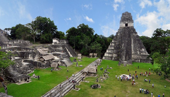
Tikal Mayan ruins in Guatemala. Credit - chensiyuan, WIkimedia Commons.

Tikal Mayan ruins in Guatemala. Credit – chensiyuan, WIkimedia Commons.

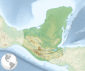
The Maya Civilisation can be traced as far back as 2000 BC and occupied southern Mexico and northern Central America (including the modern territories of Guatemala, Belize and Honduras). It prospered until 900 AD and continued until the arrival of the Spanish. Their golden age between 300 and 900 AD is a period characterised by flourishing art and architecture as well as developments in mathematics and astronomy. Mayan cities are dotted throughout Central and South America, the more famous sites include Chichen Itza and Palenque in Mexico and Tikal in northern Guatemala (see this map of the geography of the Mayan civilisation).

So… How does geology relate to this great civilisation? Elements of geology came into the daily lives of the Mayans in many forms through their building materials, the siting of their cities and the materials and minerals they used for trading, building infrastructure and creating objects used in their everyday lives. Climate change may also have greatly influenced the Mayan people and is thought to have led to both the expansion and the disintegration of this civilisation. We take a look at these different aspects below.

Siting of Mayan cities

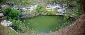
The name of the city ‘Chich’en Itza’, located in Mexico, means ‘At the mouth of the well of Itza’. This refers to its location close to several ‘Cenotes’ (or in English, sink-holes). Sinkholes are cavities in the ground, often in limestone formations, caused by water erosion – these have received a lot of press recently due to their building swallowing activity! Find out more about sinkholes here. It’s thought that Cenotes provided access to the underworld, due to the discoveries of skeletons in sinkholes and caves near to archaeological sites. The cenotes were also fed by underground rivers, which provided water for the population.

Cenotes

Cenotes at Chichén Itzá, Yucatán Peninsula, Mexico. Credit – Emil Kehnel, Wikimedia Commons.

Building and Architecture

Mayan cities grew by using sacbeob (white roads, or limed causeways)  to connect great plazas and temples. These were made from limestone  due to its ease of handling and local availability.  Stone for buildings was taken from local quarries. Limestone was preferentially used because it was easy to remove using the stone tools available and because it could be used to make mortar through crushing and burning. Limestone was also used for both mortar and stucco.

Agriculture and Natural Hazards

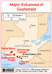
Map of Guatemala volcanoes. Credit - USGS, Wikimedia Commons.

Map of Guatemala volcanoes. Credit – USGS, Wikimedia Commons.

One might expect a civilisation that prospered over a long period of time to have developed a thriving agriculture to meet the needs of an expanding population. But limestone is the dominant rock type in the area and does not usually generate good soil. Many Mayan cities are therefore believed to have had poor soils which puzzled scientists and archaeologists as to how they could sustain such great cities.

In a recent article in National Geographic, it was suggested that volcanic ash had been ‘spectacularly important’ in Mayan agriculture. Recently scientists discovered a distinct beige clay mineral, a type of smectite (the same mineral recently found on Mars!), in ruined canals at Guatemala’s Tikal archaeological site—once the largest city of the southern Maya lowlands. Chemical fingerprinting techniques were used to show that the smectite at Tikal didn’t come from dust carried over from Africa by air currents as previously thought but from volcanoes within what are now Guatemala, El Salvador, Honduras, and Mexico. The volcanoes in this region are produced by subduction of Pacific oceanic crust beneath the North American and Caribbean Plates. Volcanoes also brought their fair share of disaster to the Mayans. A village in El Salvador was completely buried when the nearby Ilopango volcano erupted in the 6th century A.D, not unlike the more famous Mt Vesuvius eruption in 79 AD, which buried the cities of Pompeii and Herculaneum.

Commodities, trade and minerals

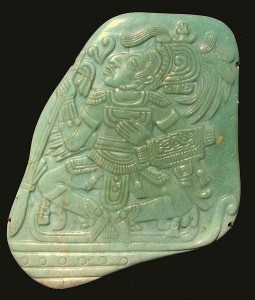
Jadeite Pectoral from the Mayan Classic period. Credit - John Hill, Wikimedia Commons.

Jadeite Pectoral from the Mayan Classic period. Credit – John Hill, Wikimedia Commons.

Trade of commodities and minerals was a crucial factor in Mayan society. Trade centred around foodstuffs and raw materials including limestone, jade, marble, copper and gold. Goods such as jade, pyrite and fine ceramics were used to show power and primarily catered to the wealthy. The minerals jade and pyrite were collected in the highlands of Central Guatemala, made up of two mountain chains running from west to east. The area is made up of large stratovolcanoes and many basaltic volcanic fields (more information on the mountains and volcanoes of Guatemala can be found here).

Also important, was the volcanic glass obsidian which was used to make tools for cutting. Initially these minerals were only used locally to where they were sourced, but all of them eventually ended up being traded long distance.

Climate change and the fall of the Maya empire

The reasons for the collapse of the Mayan civilisation have troubled archaeologists and scholars for years. It has been attributed to a number of different factors, including internal warfare, foreign intrusion, agriculture, disease, environmental degradation and climate change. During the mid 1990s, scholars began to propose that extended drought and lack of water during the period from 750-1000 AD was the principal cause of the disintegration of the major Mayan centres and the collapse of the civilisation. The first geological evidence that this may have been the case came from sediment cores drilled from lakes on the Yucatan Peninsula, now in southern Mexico (and home to the famous Chicxulub crater).

Map of the Maya civilization cultural area. Credit - Sémhur/Wikimedia Commons.

Map of the Maya civilization cultural area. Credit – Sémhur/Wikimedia Commons.

In a paper published in the journal Quaternary Research in 1996, Jason Curtis and his colleagues presented results from sediment cores drilled in Lake Punta Laguna in Yucatan. They used the oxygen isotope composition of the shells of organisms found in different sediment layers to show that the end of the Mayan civilisation coincided with consistently dry climate between 800 and 1000 AD, with particularly dry years overlying a general drying trend.

The oxygen composition of lake water is an important tool for understanding changes in the hydrological cycle in an area. A molecule of water, H2O, can be made of the more dominant light oxygen isotope 16O or the heavier 18O. In a closed-basin system such as the Yucatan lakes, the oxygen composition of the water (i.e. the ratio of 18O to 16O water molecules) is thought to primarily reflect changes in the balance between evaporation and precipitation. During dry periods, when precipitation is low and evaporation high, the lighter 16O isotope is more easily evaporated and preferentially removed from the water, leaving the heavier 18O in the lake. Dry periods are therefore characterised by a heavier oxygen isotope ratio in the lake waters. During wetter periods, the opposite phenomenon occurs and the lake waters are characterised by a lower oxygen isotope ratio. The oxygen isotope composition of the water is reflected in the shells of organisms alive at each time. As they die and get deposited on the lake bottom, these organisms record a slice of climate information.

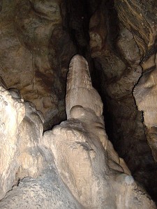
A stalagmite in the Witches' Cave, Argentina. Credit - Pablo Flores, Wikimedia Commons.

A stalagmite in the Witches’ Cave, Argentina. Credit – Pablo Flores, Wikimedia Commons.

This data was corroborated by later measurements in the Cariaco Basin of the southern Caribbean. In a paper entitled ‘Climate and the Collapse of the Maya Civilisation’, Haug and co-authors used the titanium (Ti) concentration of sediment layers to reconstruct the hydrological history of Central America during the first millennium AD. Titanium concentrations reflect riverine input to the basin and Ti is therefore deposited during wet periods, when runoff increases and terrestrial material gets driven towards the coast. The authors also found an extended dry period between 800 and 1000 AD, punctuated by particularly severe droughts around 810, 860 and 910 AD.

Last year, a third set of palaeoclimate data was published in Science by Kennett and co-authors. They measured oxygen isotope data in a cave in Belize. Cave deposits such as stalactites and stalagmites grow as water drips through the cave. The oxygen composition of the rainwater is reflected in these deposits and they provide a very high-resolution record of precipitation. Yet again, a dryer period was recorded between 660 and 1000 AD, during the collapse of the Maya Civilisation.

So from trade, to religion, agriculture and society, geology has helped researchers understand the evolution and demise of this great civilisation.

Flo and Marion